
Hands on: Google Maps 5.7 adds stop-by-stop public transit Nav. and offline maps to Android

google-maps-public-transit-web
Image used with permission by copyright holder

Google has added some much needed public transit support to its Google Maps app, it revealed in a blog post today. Google Maps 5.7, now available on the Android Market, adds turn-by-turn (or “stop-by-stop”) GPS transit navigation for more than 400 cities around the world, with more on the way soon. A useful Google Labs feature that allows you to download offline maps (10 square miles at a time) has also been added.

Like turn-by-turn navigation, the Transit Navigation (beta) uses GPS to determine your location along routes that Google downloads from local transit companies or governments. The app warns you when your stop is coming up with notifications and will vibrate when it’s time to get off, even if you’re doing other things on your phone. While Google had a transit option on its Website before, the feature now seems to work a bit more accurately and is now supported on the Android Maps & Navigation app.

google-maps-transit-navigation
Image used with permission by copyright holder

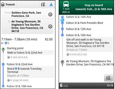
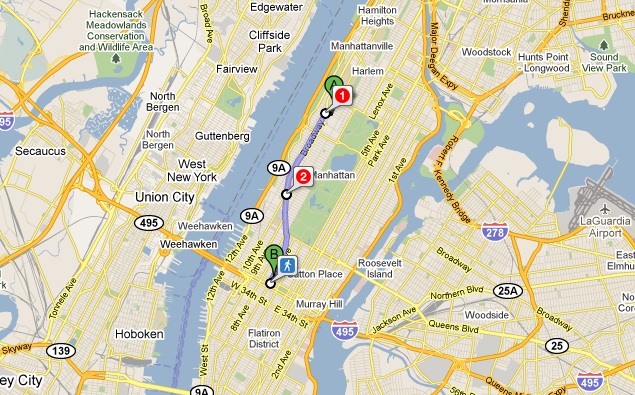
We tested out the navigation here in New York City to mixed results. While we like the option of navigating public transit on Google Maps, the service still pales in comparison to the accuracy of competing services like HopStop. Maps 5.7 Transit Nav. led us to a further stop than we could have used a few times and the app doesn’t have granular options to let you choose between bus transit and the subway, or how much walking you’re comfortable doing. In addition, though it will advise you to take the subway, it is completely useless once you head underground due to a complete lack of mobile data connections in the NYC subway system. For this reason alone, we’ll be sticking with HopStop, which doesn’t have the pretty maps that Google’s app does, but it works and gives us control over how we’d like to travel and the ability to look for alternate routes.

Offline, kind of

We are happy that Google has added some offline features. Now, when you re-enter Google Maps, it will show you the set of directions–walking, car, or public transit–that you last viewed. It would be nice if Google took this a step further and let you save directions or destinations to your phone memory (and online) for future reference. Again, this is most useful in cities like New York where public transit takes you off the mobile grid for extended periods of time.

The new Google Labs feature for offline storage solves some of these problems. The feature allows you to select an address and download 10 square miles of map data around it. To download an entire city or region, you must download it in square chunks. Still, once you have the data, you have it, so for those with limited data connectivity (or crappy data plans), it is a good option for basic navigation. The download took us about 30 seconds. It looks like it downloads those fancy 3D buildings Google introduced last December as well.

Below is a Google video explaining the features of the new Google Maps 5.7.

And here is a quick demonstration of the Offline maps feature via MobileBurn.

Jeffrey Van Camp
Former Digital Trends Contributor
As DT's Deputy Editor, Jeff helps oversee editorial operations at Digital Trends. Previously, he ran the site's…
One of the biggest Oura Ring competitors just did something huge
The Ultrahuman Ring Air and the Oura Ring, resting on a table.

Ultrahuman, the maker of the Ultrahuman Ring Air, is making its way to U.S. production grounds. The company is setting up a production facility in Indiana, which will mark the first time a smart ring from Ultrahuman will be assembled from scratch on U.S. soil.

“The UltraFactory will offer an end-to-end production capability and is based on the company’s first operational model of such a facility in India,” the company says.

Read more
Best Verizon new customer deals: Galaxy S24, iPhone and more
Verizon logo on a smartphone screen in a dark room and a finger touching it.

If you’re in the market for one of the best phones, or any new phone for that matter, you’re going to need a good carrier. Verizon has long been one of the most popular options, as it boasts one of the most reliable networks in the United States. It offers some of the best cell phone plans out there, and for new customers Verizon also offers some pretty impressive discounts on new phones. In many cases this means you can brand new, recently released phones entirely for free when signing up with Verizon. And that’s the case right now, as we’re currently seeing some of the best Verizon new customer deals we’ve seen. You can pretty easily land a new iPhone, Samsung Galaxy phone, and Google Pixel for free, and we’ve got all of the details on how to do so. If that sounds enticing, read onward and start shopping the best Verizon new customer deals available right now.
Free iPhone SE (3rd Gen)

The 2022 release of the Apple iPhone SE is yours for free when you sign up for a new 5G data plan on Verizon -- no trade-ins required. It's the best small smartphone in our list of the best smartphones with a 4.7-inch Liquid Retina display, but it doesn't sacrifice performance as it's powered by Apple's A15 Bionic chip that's also found in the iPhone 13 line and pre-installed with iOS 15. The latest iPhone SE is equipped with a single 12MP rear sensor and 7MP selfie camera, which are boosted by Apple's software to enable better photographs.

Read more
AirTags range: here’s how far the tracker can reach
An AirTag attached on a keyring

Apple AirTags are a helpful tool for tracking valuable possessions like wallets, keys, luggage, and backpacks. These tags employ various technologies that allow you to track your items from short and long distances using your compatible Apple device, such as an iPhone 15 Plus. You might wonder how far you can track your items with AirTags. It's time to find out.
AirTags range, explained

The range of AirTags varies depending on the method you use to locate them. A Bluetooth connection will work when your AirTags are close to your supported Apple device. Otherwise, Apple's Find My network is utilized. Luckily, you don't have to choose the method because it's selected behind the scenes automatically.

Read more