
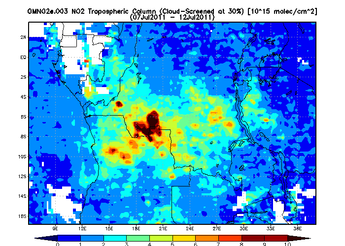
Massive fires in central Africa have emitted an enormous amount of pollution, which was recently measured by NASA’s Aura satellite. The resulting image, above, shows a dark-red “butterfly” of high-density air pollution hovering over the border between the Democratic Republic of the Congo to the north and Angola to the south.
The pollution is caused by massive annual agricultural burns. The fires are used to clear the remains of harvested crops, to clear and induce growth of grazing land, and, oddly enough, to coordinate livestock herding. Apparently nothing helps move cattle like a raging fire nipping at their hooves.
Crops and other plant material have high levels of nitrogen. When burned, the nitrogen released into the atmosphere mixes with atmospheric oxygen to create nitrogen dioxide, or NO2. The compound reacts with sunlight to create low-level ozone, affectionately know as smog, and terrible air quality. Smog is known to cause health problems for both plants and animals. In combination with particulate matter like the tons of ash pumped into the air from huge fires, smog is known to cause respiratory problems in humans.
The Aura satellite’s Ozone Measuring Instrument is able to record NO2 levels, and did so over central Africa from July 7 to July 12. The data recorded was compiled by Dr. James Acker at NASA’s Goddard Space Flight Center to produce the above image. In the image, dark red indicates the highest concentrations of NO2.


