
Philly cops disguised a surveillance vehicle as a Google Street View car

street view car disguise philly cops
Matt Blaze
When science professor Matt Blaze recently spotted what purported to be one of Google’s Street View mapping cars puttering around the streets of Philadelphia, he knew something wasn’t quite right. For starters, the camera atop the car bore no resemblance to the one used by Google’s mapping team, and its “Street View” design was, quite frankly, a bit crap.

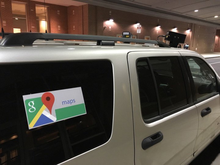
As Blaze inspected the vehicle more closely, his suspicions were confirmed as visible documents on the dashboard strongly suggested it belonged to the Philadelphia Police Department. Smelling something fishy (though not literally, as far as we know), Blaze hit Twitter with news of his shock discovery:

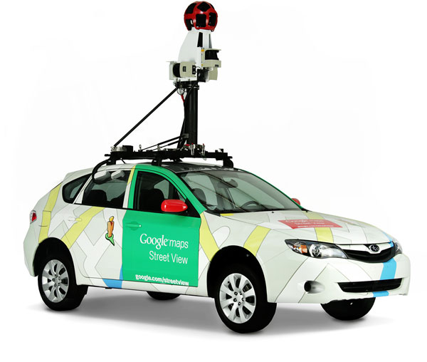
Following initial confusion about who really did own the vehicle, it later emerged that the camera was part of the police department’s automated license plate recognition kit and nothing at all to do with capturing panoramic images for Google’s popular online service.

google street view car
Spot the difference: A REAL Street View car. Image used with permission by copyright holder

In a statement to Motherboard, a spokesperson for Philadelphia police said, “We have been informed that this unmarked vehicle belongs to the police department; however, the placing of any particular decal on the vehicle was not approved through any chain of command. With that being said, once this was brought to our attention, it was ordered that the decals be removed immediately.”

Not surprisingly, Google has said it’s investigating the unauthorized use of its Google Maps logo, though declined to comment further on the incident.

Cops haven’t stated explicitly why its vehicle sported the Google Maps decal, but the obvious explanation is that it didn’t want to alert nearby drivers  – especially ones who for whatever reason are keen to steer clear of law enforcement – as to the true nature of its operation.

License plate readers have long been the subject of controversy, with privacy campaigners voicing concern about how the technology collects and stores data in what many consider to be an unrestricted mass surveillance program. The technology is capable of recording and checking plates not only in front of the car but all around it, allowing it to record potentially hundreds of plates a minute. You can read more about how it works here.

As for the Philly incident, it certainly isn’t Google’s first road-based run-in with the cops – though this time the shoe is clearly on the other foot.

Editors' Recommendations

Trevor Mogg
Contributing Editor
Not so many moons ago, Trevor moved from one tea-loving island nation that drives on the left (Britain) to another (Japan)…
Google showcases natural underwater beauty in new Street View images
new google street view underwater images 1

Turns out, you can use Google's Street View for more than just exploring the actual street. Street View could already be used to explore underwater locations, but Google has expanded the feature to include a few new beautiful underwater destinations.

The new images, which are available in a Google Earth collection, aren't just there to help people explore the beauty that's under the ocean -- they're also aimed at reminding users of the impact that humans have had on the environment. Just as there are bright, vivid corals and beautiful underwater landscapes, the images also show bleached and dying coral, plastic, and so on.

Read more
Apple Maps adds Street View-style imagery, but with a neat trick
apple maps adds street view style imagery but with a neat trick look around

Apple Maps has well and truly moved on from its nightmare start in 2012 and is now aiming to navigate its way to even greater heights with the launch of iOS 13 later this year.

The overhauled app is bringing with it a slew of new features, including a new Street View-style tool called Look Around that lets you explore a place as if you were there.

Read more
Google’s Street View cars are helping build a giant map of global air pollution
Google wants to map the world's air quality. Here's how.
Google Street View Vehicle equipped with pollution tracking tech

You’re out on your first jog in more than a week. You’ve been running for maybe a half hour when you’re suddenly overcome by a shortness of breath. Your chest feels strangely tight, and as you breath you emit an odd rasping, wheezing noise. Is it your fitness level that’s faltering, you wonder, or could there be some external reason your body is responding like this.

You pull up Google Maps on your smartwatch. Along with a dot showing your present location, there’s also some contextual information about your surroundings, revealing that you’ve run into a section of town where air pollution levels are excessively high. Another app, drawing on this information and your own health data, suggests that the air quality levels might be triggering your asthma. With a couple of taps of the wrist, you reconfigure Google Maps and plot a route that will take you home via some parks where clean air is in ready supply.

Read more