
Wildfire Info
3.9star
186 reviews
50K+
Downloads

Everyone
info


About this app
Disclaimer: This unofficial app does not represent any government agency and is not affiliated with any government agency. The sources of the data are the publicly accessible sources listed below.
Browse current wildfire and prescribed burn activity throughout all of the world.
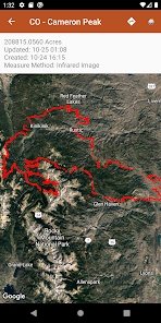
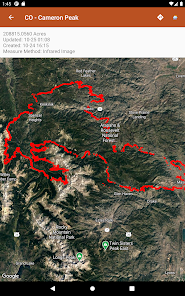
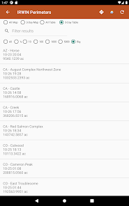
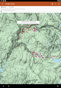
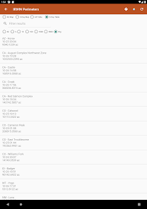
Active Wildfire Perimeter data from WFIGS updated every 20 minutes. Tagged by state, search by name, and filter by acres burned. WFIGS stands for the Wildland Fire Interagency Geospatial Services (WFIGS) Group
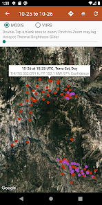
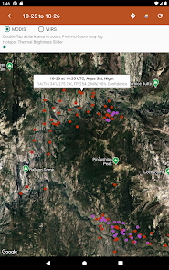
NASA MODIS and VIIRS satellite instruments data: Thermal hotspot maps by region show wildfire activity in the past 48 hours. See hotspot info including fire radiance power, brightness temperature, and confidence.
Air Quality data (PM 2.5, PM10, and Ozone) globally from EPA AirNow and PurpleAir.
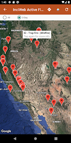
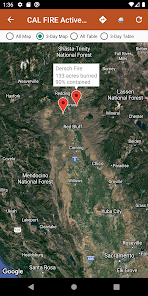
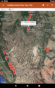
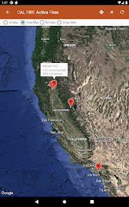
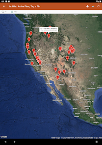
InciWeb & CAL FIRE active fire maps: hot-link to the corresponding official incident webpage.
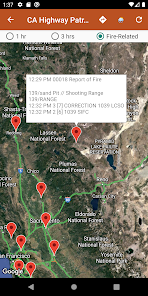
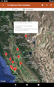
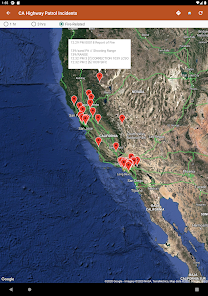
CHP (California Highway Patrol): Incidents in the past 3 hours related to fires are filtered out separately, all traffic incidents are included viewable by last 1 or 3 hours.
Links to current hyper-local weather summary conditions from NWS, NOAA, Government of Canada, and Government of Australia: including temperature, wind and gust conditions, and local forecasts anywhere in the USA, Canada, or Australia at your centered map location.
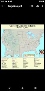
Wildfire Situation Reports section with mirrored PDFs from NIFC and more.
Pull up the Google Maps app for an area with the embedded deep links.
There is a section for wildfire-related US government Twitter accounts viewable by map by approximate location or sorted into national and state sources in a table view.
Information is posted as soon as it becomes available from WFIGS, NIFC, NASA, InciWeb, CAL FIRE, CHP, NOAA, NWS, Government of Canada, and Government of Australia.
Browse current wildfire and prescribed burn activity throughout all of the world.
Active Wildfire Perimeter data from WFIGS updated every 20 minutes. Tagged by state, search by name, and filter by acres burned. WFIGS stands for the Wildland Fire Interagency Geospatial Services (WFIGS) Group
NASA MODIS and VIIRS satellite instruments data: Thermal hotspot maps by region show wildfire activity in the past 48 hours. See hotspot info including fire radiance power, brightness temperature, and confidence.
Air Quality data (PM 2.5, PM10, and Ozone) globally from EPA AirNow and PurpleAir.
InciWeb & CAL FIRE active fire maps: hot-link to the corresponding official incident webpage.
CHP (California Highway Patrol): Incidents in the past 3 hours related to fires are filtered out separately, all traffic incidents are included viewable by last 1 or 3 hours.
Links to current hyper-local weather summary conditions from NWS, NOAA, Government of Canada, and Government of Australia: including temperature, wind and gust conditions, and local forecasts anywhere in the USA, Canada, or Australia at your centered map location.
Wildfire Situation Reports section with mirrored PDFs from NIFC and more.
Pull up the Google Maps app for an area with the embedded deep links.
There is a section for wildfire-related US government Twitter accounts viewable by map by approximate location or sorted into national and state sources in a table view.
Information is posted as soon as it becomes available from WFIGS, NIFC, NASA, InciWeb, CAL FIRE, CHP, NOAA, NWS, Government of Canada, and Government of Australia.
Updated on
Safety starts with understanding how developers collect and share your data. Data privacy and security practices may vary based on your use, region, and age. The developer provided this information and may update it over time.

No data shared with third parties
Learn more about how developers declare sharing

No data collected
Learn more about how developers declare collection
Ratings and reviews
3.9
174 reviews

Linda Chicago
- Flag inappropriate
- Show review history
November 27, 2022
Great app! Exactly what I was looking for! To be able to monitor wildfire, air quality and weather forecasts all in one app! Thank you! Oh, it would be great if you could add in AZ Highway Patrol like you have it for CA, but I can find that elsewhere. Would be nice, though. Love that your app works very quickly unlike many websites on these topics which are often very slow.
5 people found this review helpful
David Gross Apps
January 25, 2023
Thank you for your specific feedback and for downloading our app! We will keep working on it!

Sophi Martin
- Flag inappropriate
August 25, 2020
I wanted to like this. It has good source data, but it's all disaggregated across a bunch of menus. Too difficult to navigate and I don't know where to find different parts. I'd love to have an app that just has one map with layers that show perimeters, evacuation zones, containment info, etc. This unfortunately doesn't have that.
43 people found this review helpful
David Gross Apps
May 12, 2022
The evacuation zone info, I am looking into it.

Kalia Kliban
- Flag inappropriate
July 6, 2021
I'd give the app a lot more stars if it didn't shut down almost every time I try to look at anything. Doesn't seem to matter which modality I select, the app stops working. When it _does_ work, it's very handy, but I can't rely on it and that's a deal breaker. I'll keep it installed for a while but will be shopping for a different app in the meantime.
18 people found this review helpful
David Gross Apps
October 16, 2021
Hi, can you please try reinstalling the app. An update was issued Version 2.7 October 14, 2021. Please contact us at davidgrossapps@gmail.com if the issue persists.
What's new
- Fix for crash when navigating throughout the app on poor network conditions or if navigating too quickly
- Additional fix for crash when loading maps due to map load race condition
- Fix for crash when tapping Map Tools popup on InciWeb Map view
- Removed duplicate Map Tools crosshair for WFIGS perimeters, and prevented this from potentially happening on other screens
- News section removed for now, being re-worked and may be re-introduced in the near future in a different way
App support
phone
Phone number
+19515957097


