
Photo op: This interactive foliage map will help you plan your fall adventures

If it’s hot and humid where you are right now, rest assured that cooler weather is just around the corner.

Fall is a big relief for many folks as it allows us to venture outdoors again secure in the knowledge that our bodies won’t spring multiple leaks for sweat to pour forth, leaving our clothes looking like we just emerged from a lake.

The more comfortable weather also means the arrival of those beautiful fall colors with the foliage exploding into a fiery display of vibrant reds, oranges, and yellows.

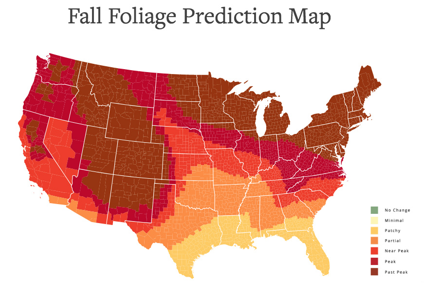
If you’re planning to get out and about in the coming months, then you might want to take a quick look at the interactive Predictive Fall Color Map before you plan your route.

Described by its creator, tourism website SmokyMountains, as “the ultimate visual planning guide to the annual progressive changing of the leaves,” the map lets you pull a date slider from left to right that reveals how the leaves will change and where the colors will peak across the U.S. from now through mid-November.

The color key describes the foliage as no change (that’s now), minimal, patchy, partial, near peak, peak, and past peak.

SmokyMountains points out that “no tool can be 100 percent accurate,” but adds that its own effort “is meant to help travelers better time their trips to have the best opportunity of catching peak color each year.”

Photo opportunity

Using data collated from social media, Nikon each year designates the best state for fall foliage photography. For the last two years Michigan has taken the top spot, with New York taking the title in 2015.

While New England is one of the most popular parts of the country among those keen to enjoy the autumn colors, there are a number of other locations across the U.S. that offer up their own dazzling displays of color.

Of course, SmokyMountains would be delighted if you paid a visit to the Great Smoky Mountains National Park, too, to marvel at its own fall spectacle. Straddling the border between Tennessee and North Carolina, the Great Smoky Mountains foliage will peak toward the end of October, according to the interactive map.

Editors' Recommendations

Trevor Mogg
Contributing Editor
Not so many moons ago, Trevor moved from one tea-loving island nation that drives on the left (Britain) to another (Japan)…
Google Maps can help you find a parking spot in 25 cities outside the U.S.
Google Pixel

As part of its latest update, Google added 25 more cities outside the U.S. for people to use parking difficulty icons via Google Maps for Android and iOS. The icons inform you ahead of time of how difficult it is to park wherever you are headed.

To find out how hard it could be to park, simply get directions to your destination and look for the parking difficulty icon in the directions card at the bottom of the screen. Based on historical parking data and machine learning, parking difficulty levels can vary from limited to medium to easy.

Read more
Snapchat’s new Snap Map will show you where your friends are
Snapchat Snap Map

It is no secret that Snapchat has been hit hard with strong competition from Facebook-owned Instagram over the past year, but the social media company is not taking it lying down. On Wednesday, it announced its newest feature addition -- Snap Map.

The new location-based Snap Map is Snapchat’s way of trying to help users see what is going on around them with other users and events. The feature also gives users a new way to follow their friends, with not only what they are snapping on their own, but what others are snapping at that location as well. It is a move that Snapchat is hoping will strengthen the community and help make connecting with old and new friends on the service easier.

Read more
Google Maps helps you find Pride Month events in 35 cities around the world
google maps

It's LGBT Pride Month in many cities around the world, and you might be wondering where you can get to join in the celebrations. Well folks, Google Maps is here to help! The company has updated Google Maps on Android and iOS with Pride parade routes to help participants find where the party is and where the party is going.

The new feature will be available in 35 cities around the world, and in the cities where it's available you'll be able to head to Google Maps to see a rainbow route showing exactly where the parade will take place. From there, you can tap the event to show more information like the kind of traffic you'll run into, event hours, and a description of the event.

Read more