The new location-based Snap Map is Snapchat’s way of trying to help users see what is going on around them with other users and events. The feature also gives users a new way to follow their friends, with not only what they are snapping on their own, but what others are snapping at that location as well. It is a move that Snapchat is hoping will strengthen the community and help make connecting with old and new friends on the service easier.
You would not be out of place to be wondering about your privacy with this feature, but don’t worry privacy warriors, you can turn on a “Ghost Mode,” which hides your location from your friends and prevents you from showing up on the map. Snapchat made it clear that this feature will help you connect with friends and those around you, but only if you want it to.
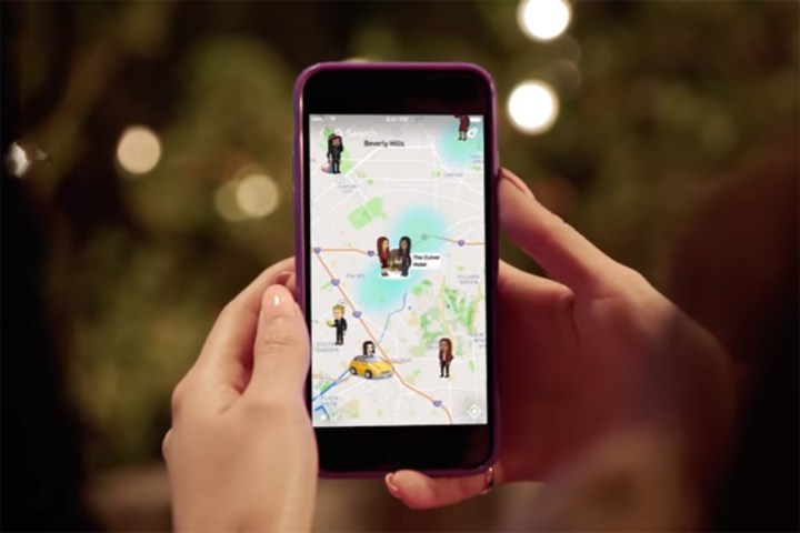
If you decide to opt-in and allow Snap Map to share your location data, then your Actionmoji will appear on the map. Other users will then be able to see your snaps and the snaps of others at that location.
Accessing the Snap Map is easy as well, Snapchat added the map as a new layer over the current Snapchat experience. All you have to do to open and view the map is pinch to zoom from the Snapchat camera. The first time that you open the Snap Map you will be taken through a little tutorial that explains the feature and how to use it.
The Snap Map feature is already available for both iOS and Android users with a new update that is currently rolling out across both platforms. If you would like to check out the new Snap Map feature, all you need to do is update your app once the update becomes available to you.
Editors' Recommendations
- Solve a creepy mystery with Snapchat’s new in-app AR game
- Waze vs. Google Maps: Which one is right for you?
- How to stop apps from tracking your location in Android and iOS
- Apple Maps vs. Google Maps: Which one is best for you?
- Google Maps’ new community feed aims to keep you in the loop