
Street View: Google posts imagery of town evacuated after Fukushima disaster

namie 1When the tsunami and earthquake struck north-east Japan in March 2011, the devastation caused multiple meltdowns at the Fukushima nuclear plant, which in turn resulted in the rapid evacuation of nearby towns such as Namie, population 21,000.

Two years on, an exclusion zone around the town remains in place, with the displaced residents still wondering when, or even if, they’ll ever have a chance to return to their homes.

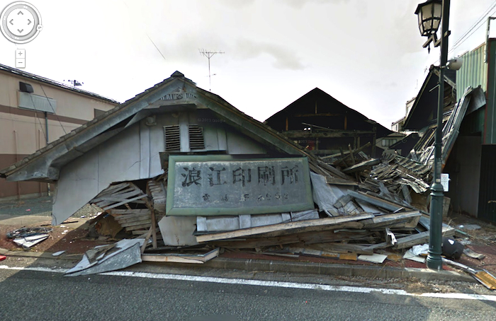
Frustrated that decontamination work has still not started and worried the plight of the area and its people is slowly being forgotten, the mayor of the town, Tamotsu Baba, invited Google to document the streets of Namie with its Street View cars.

“By photographing the town and making those photographs publicly available, we can show the townspeople the condition of the streets,” Tamotsu Baba said earlier this month. “In addition, I want to show the world the true state of Namie.”

namie 2

After gathering images of the deserted town in early March, Google added them to its Street View service on Wednesday.

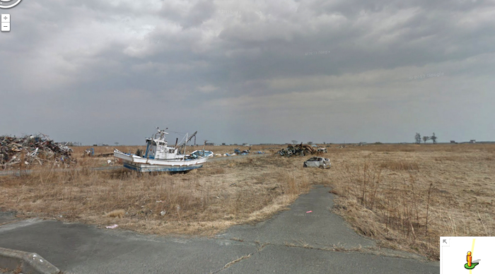
The striking imagery shows deserted streets, damaged buildings, overgrown parking lots and, towards the coast, fishing boats washed onto land by the tsunami.

namie 3

In a guest post on Google’s official blog, Mayor Baba encouraged people to view the Street View imagery of his town.

“Ever since the March disaster, the rest of the world has been moving forward, and many places in Japan have started recovering,” he said in the post. “But in Namie-machi time stands still. With the lingering nuclear hazard, we have only been able to do cursory work for two whole years.

“We would greatly appreciate it if you viewed this Street View imagery to understand the current state of Namie-machi and the tremendous gravity of the situation.”

Baba said the older generation of the town feels “great pain” that they’re unable to hand the town down to their children, as many of them will have passed on before they have a chance to go back home.

And as Mother Nature slowly begins to reclaim the land, Baba said the people of Namie were determined to one day return.

“Finally, I want to make a renewed commitment to recovering from the nuclear hazard,” he wrote. “It may take many years and many people’s help, but we will never give up taking back our hometown.”

Editors' Recommendations

Google details Street View certification program covering cameras and software
google street view certification program maps with exhibit at the computer history museum

Google has detailed a new initiative that's intended to ease the process of uploading imagery to its Street View service. The company's Street View certification standard will help anyone who is eager to contribute to the service choose software and hardware that's fit for the job.

Twenty new 360-degree cameras that are certified by the program are set to be made available over the course of 2017, according to a post on the Google blog. Sphericam, Z CAM, Giroptic, and Insta360 are among the manufacturers fielding the first wave of devices to be approved by Google.

Read more
You can now explore seven countries in Africa thanks to Google Street View
google street view africa 3  width 2000

Globetrotting can be hard, but Google is here to make it easier -- not when it comes to flight and hotel accommodations, but rather with an ever-expanding repository of the most incredible sights from around the world. Google has added some of the highlights from the majestic continent of Africa to its Google Street View knowledge base and starting today, you'll be able to take virtual tours of "some of the most iconic landmarks and monuments in Ghana, Senegal, and Uganda."

You can now explore a total of 81 countries without ever leaving your home by way of Google Street View, seven of which are located in Africa. There's the UNESCO World Heritage-classified village of Nzulezo in Ghana, built over Lake Tadane, whose stilt-supported structures are integrated with the water-centric landscape of the area.

Read more
Japan’s Kumamoto quakes likely had a major effect on camera production
Sony A7S II

It’s been over three months since Sony’s Kumamoto Technology Center restarted production after a series of earthquakes took it offline in April. The facility was responsible for supplying the imaging sensors that live at the heart of many digital cameras and smartphones, both from Sony and many other manufactures. Finished sensors are finally starting to roll off the assembly line, but it may still be some time before the camera industry fully recovers.

The quakes, including a magnitude 6.2 foreshock on April 14 and magnitude 7.0 mainshock on April 16, occurred less than seven miles below the Earth’s surface. That means their effect was actually quite a bit larger compared to what the (already severe) moment magnitudes would indicate. This is illustrated in the mainshock registering a magnitude 8.8 on the Mercalli scale, which takes into account the physical effects caused by a quake. Sony’s Kumamoto facility was located just five miles from the epicenter.

Read more