
If you’re a pilot hurtling down the runway at great speed just prior to take-off, there are certain things you don’t want to see.
You don’t want to see a flock of birds lifting off the ground at the same time as you (possible); you definitely don’t want to see an elephant that’s escaped from the local zoo stepping out in front of you (unlikely); and you most certainly don’t want to see a car appear on the runway driven by someone looking confusedly at their iPhone (possible if you’re flying out of Alaska’s Fairbanks International Airport).
Yes, folks, it’s been a while since any ‘fail’ stories regarding Apple Maps hit the headlines, but here’s a new one that we thought you might like to hear about – especially if you’re a pilot that uses the aforementioned airport.
Remember, runways are for planes
The problem is, the app’s turn-by-turn directions have been leading some drivers onto one of the airport’s taxiways. If that wasn’t bad enough, at least two drivers in the last three weeks have driven from the taxiway across the runway to get to the main terminal building. Keep in mind, this is an airport that sees some pretty big aircraft flying in and out, including Boeing 737s.
Though the flaw in the supplied directions is obviously highly troubling, you’d think those involved might’ve thought something was up when they found themselves on one of the airport’s taxiways alongside, y’know, planes ‘n’ things.
“These folks drove past several signs,” Melissa Osborn, chief of operations at the airport, told Alaska Dispatch. “They even drove past a gate. None of that cued them that they did something inappropriate.”
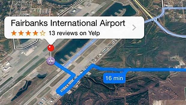
Alaska Dispatch described the directions as “specific”, instructing drivers “to go to Taxiway Bravo, shown as ‘Taxiway B’ on the satellite image in the app.” The directions didn’t, however, suggest crossing the main runway.
Fearing a serious incident, the airport authorities contacted Apple immediately after the first runway crossing on September 6 to report the flaw. The Cupertino company said it would issue a fix, but last Friday another driver ended up on the taxiway prior to making their way across the runway.
Consequently, the airport issued a notice to pilots warning them of oncoming traffic. “Please remain vigilant when on the east ramp,” it said. “Watch for drivers who appear unfamiliar and report them to the airport.” It also closed part of an aircraft access route in an effort to prevent drivers ending up on the taxiway.
Apple appears to have finally disabled directions to the airport, which is good news for pilots but bad news for iPhone-equipped out-of-town travelers trying to find their way there….but hey, there’s always Google Maps.
Maps mishaps
When it launched exactly a year ago, Apple Maps was panned by many for mislabeling locations and lacking detailed information.
In Australia, for example, police had to carry out several rescue missions for people who became lost in one of the country’s national parks after using the app.
It was in such a bad state that Tim Cook felt moved to issue a letter of apology for the misstep.
In the past 12 months, however, the company has been rolling out updates to improve its usability, though clearly it still has some work to do – especially when it comes to Fairbanks International Airport.


