
With this in mind, the company is planning to invest a hefty half a billion dollars in boosting its mapping technology and data, enabling it to rely less heavily on Google Maps and helping it toward its lofty goal of a ridesharing service using driverless vehicles.
The intention to double down on its investment in mapping was revealed by Uber last week, while the $500 million figure was disclosed over the weekend to the Financial Times by an unnamed source familiar with the company’s plans.
Brian McClendon, Uber’s mapping expert who also once led the Google Maps team, said in a recent blog post that “existing maps are a good starting point” but fail to provide the detailed information necessary for building the most effective and efficient ridesharing service possible.
He explained, “There are other things we need to know a lot more about, like traffic patterns and precise pickup and drop-off locations. Moreover, we need to be able to provide a seamless experience in parts of the world where there aren’t detailed maps – or street signs.”
The San Francisco-based company already has mapping vehicles on the roads in the U.S. and Mexico, but this latest investment looks set to take the technology across the world, similar to how Google’s Street View cars have been traversing the globe for the last 10 years.
Uber’s other efforts to bolster its maps led to a recent deal with DigitalGlobe, a provider of high-res satellite imagery, “to help identify and improve pick-up and drop-off locations.” It also acquired mapping firm deCarta last year, as well as some of the tech – and team members – behind Microsoft’s Bing Maps.
McClendon said mapping innovation will only accelerate in the coming years, “especially with technologies like self-driving cars.”
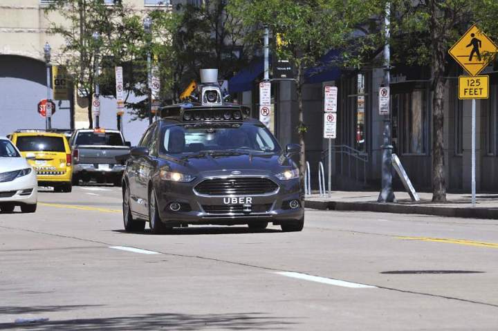
Uber CEO Travis Kalanick first revealed the company’s plans to develop self-driving technology in 2014. A short while later it partnered with Carnegie Mellon University in Pittsburgh to open the Uber Advanced Technologies Center aimed at taking the plan forward, and then in August last year it linked up with the University of Arizona to work on optics technology for improving its self-driving car’s mapping system and safety features.
Editors' Recommendations
- Waymo robotaxi attacked and set on fire in San Francisco
- Cruise woes prompt production halt of fully driverless van
- Dubai Police to deploy driverless patrol cars with AI smarts
- Cruise autonomous vehicle drives over woman just after she was hit by another car
- Cruise says it’s nearing approval for mass production of futuristic robotaxi


