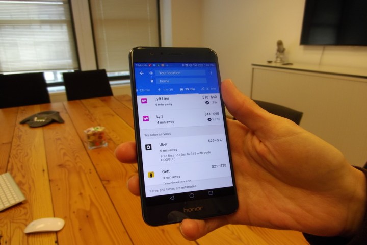
Google Maps gains Lyft and Gett ridesharing integration

google maps lyft gett hb4116
Image used with permission by copyright holder
If you fall into the all-too-common category of phone users who traipse around glued to Google Maps, then you’re probably familiar with the app’s ridesharing integration. Basically, when you’re figuring out a way to get from point A to point B, a tab in Google Maps provides an ETA and estimated fare for on-demand services like Uber.

The problem is, other apps have traditionally been left out: eschewing Uber for Juno, Fare, or Fasten required hopping out of Maps for a spell. But that’s finally changing, at least for some services. On Thursday, Google announced the addition of Lyft and Gett to the ride-hailing tab in Maps.

Maps’ ridesharing tab was added earlier this year, in March, and it’s relatively straightforward. Navigate to a place — the Empire State Building, say, or the Golden Gate Bridge — and alongside turn-by-turn walking, biking, driving, and public transit directions, you’ll see a ridesharing tab. It shows a comparison of services broken down by the tiers each offers —  for example, estimated fares for both UberX, Uber’s low-cost option, and UberXL and UberBLACK, its luxury alternatives. And you’ll see estimates for the amount of time you’ll have to spend stuck in traffic.

Starting today, Lyft and Gett’s myriad of ridesharing options will join Uber’s in Maps. Install Gett and Lyft on your phone and, depending on your geographic location, shortcuts for Lyft, Lyft Line, and Lyft Plus will begin appearing alongside the familiar Uber tiers. Google said the integrations will roll out in the iOS and Android Maps app over the coming weeks.

Lyft and Gett aren’t the first non-Uber ridesharing apps to join Maps. Earlier this year, the search giant added 99Taxis in Brazil, Ola Cabs in India, Hailo and Gett in the U.K., and Mytaxi in Germany and Spain. Today’s additions bring the total to nine across 60 countries.

These changes come hot on the heels of Maps improvements major and minor. Google introduced Lists in August, a feature which lets you organize places you’ve visited by collection (“Favorites,” “Want to go,” and “Share place”), and evidence in beta releases of Google Maps point to more significant enhancements coming. Maps might gain speed limits in driving directions, for one, plus improved integration with food delivery services like Gruhub, Eat24, and Delivery.com. And in the coming months, an (as-yet unfinished) feature might alert you of nearby available parking.

Editors' Recommendations

Kyle Wiggers
Former Digital Trends Contributor
Kyle Wiggers is a writer, Web designer, and podcaster with an acute interest in all things tech. When not reviewing gadgets…
How to use Google Maps
Google Assistant on Google Maps

Google Maps has long served as the go-to navigation tool for millions of phones, tablets, cars, and smart wearables. While everyone is probably familiar with using Google Maps to get from point A to point B, there are a multitude of multitool-like extras hiding under the hood that are worth highlighting. Over the years, Google has added features that allow you to save your favorite places, share your location with friends, and get personalized recommendations. Here is how to use Google Maps more useful but lesser-known features, like incognito mode, AR live view, sharing your location in real-time, and even finding the nearest COVID vaccination and testing site.
How to play your tunes

With all the understandable focus on driving directions and the depth of Google Maps itself, it's easy to forget Google Maps also features music controls for popular music services like Spotify, Apple Music, and Google Play Music (Android only). Here's how to get the party started.

Read more
Google Maps is adding new shopping tools for the holiday season
Person using Google Maps on a smartphone.

Google has announced several new features in Google Maps to keep you sane this holiday season by helping you avoid crowds, find your way around the malls, and even get your holiday dinner shopping done.

First off, Google is expanding its crowdedness data features for public transit and specific stores into a broader tool that it's calling "Area Busyness." This will show you how many folks are gathering in a specific neighborhood, rather than an individual store. As Google explains, you can use this information however you like, whether you want to steer clear of the crowds or seek out the hottest spots in town.

Read more
Google Lens is getting Chrome integration to help you find out-of-stock products
Google Lens shopping integration.

Google announced at its Search On event on Wednesday that it's bringing the smartphone functionality of its Google Lens to the desktop version of Chrome. Lens is an app that helps identify objects, and it's installed by default in many Android phones.

At some point in "the coming months," Chrome will receive an update to incorporate Lens-style searching into Chrome. Instead of the old highlight, then right-click, then "search Google for" three-step process, you can search a webpage directly with Lens.

Read more