
See ridged ‘brain terrain’ crater captured by Mars Express

The Mars Express orbiter has captured a series of images showing a stunning view of impact craters in the Utopia Planitia region of Mars. The European Space Agency (ESA) orbiter took the images of the craters which sit in the huge Utopia basin which has a diameter of over 2,000 miles.

This image from ESA’s Mars Express shows Utopia Planitia, a plain that fills one of three major basins in the northern hemisphere of Mars – Utopia – and has a diameter of 3,300 km.
This image from ESA’s Mars Express shows Utopia Planitia, a plain that fills one of three major basins in the northern hemisphere of Mars – Utopia – and has a diameter of 3,300 km. ESA/DLR/FU Berlin

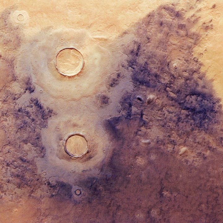
The plain in this basin, called Utopia Planitia, is of particular interest as it has abundant ice both on its surface and just below its surface. The crater on the bottom left shows an unusual texture called “brain terrain,” named such because it looks like the ridges of the human brain.

“Brain terrain is associated with the icy material found near the boundary between Mars’ northern plains and its southern highlands, a ‘dichotomy’ located to the south/south-west (upper left) of this scene,” ESA writes.

“Just to the right of the brain-textured crater is an especially dark-coloured region, created as the ice-rich ground contracted and cracked at low temperatures. This formed polygonal patterns and fractures that subsequently captured dark dust blown across Mars by wind, leading to the dark appearance seen here.”

This oblique perspective view of Utopia Planitia on Mars was generated from the digital terrain model and the nadir and colour channels of the High Resolution Stereo Camera on ESA’s Mars Express.
This oblique perspective view of Utopia Planitia on Mars was generated from the digital terrain model and the nadir and color channels of the High Resolution Stereo Camera on ESA’s Mars Express. ESA/DLR/FU Berlin

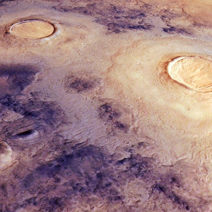
Another view of Utopia Planitia was captured as well, showing the craters from a different angle.  The two images were captured using Mars Express’s high-resolution camera for taking images of the planet’s surface, the High Resolution Stereo Camera (HRSC). They are true color images, meaning they show the view of the surface as it would be seen by the human eye.

The Mars Express orbiter has previously captured many other notable features on Mars’s surface, including the famous Korolev crater which is 51 miles wide and full of ice, and the Moreux crater which does not have ice now but does have dunes and other structures formed by ice activity in the past. Identifying ice deposits is an important step in making water available on Mars, which is key for future crewed missions there.

Editors' Recommendations

Georgina Torbet
Georgina is the Digital Trends space writer, covering human space exploration, planetary science, and cosmology. She…
Map of Mars shows the location of ice beneath the planet’s surface
In this artist’s concept, NASA astronauts drill into the Martian subsurface. The agency has created new maps that show where ice is most likely to be easily accessible to future astronauts.

One of the challenges of sending human explorers to Mars is that, due to the logistics of the journey, they will have to be on the planet's surface for considerably longer than the missions of a few days which have been sent to the moon in the past. That means future explorers will need access to resources like food, water, and oxygen -- and rather than having to carry months' worth of supplies through space, it's far more efficient to find ways to produce those resources on Mars itself.

That's the idea behind searching for water ice deposits on Mars. There's plenty of ice on the surface around the planet's poles, but most mission concepts are more focused on the planet's equatorial region. The good news is that there is ice present in these areas too, but the bad news is that it's primarily located below the surface and is thus hard to locate.

Read more
Mars flyover video shows a stunning network of valleys
mars flyover video shows a stunning network of valleys esa

Fly across Mars’s ‘labyrinth of night’ with Mars Express

The European Space Agency (ESA) has released a gorgeous video visualizing part of Mars’ Noctis Labyrinthus, a vast system of deep valleys that stretches for around 740 miles (1,190 kilometers), or for context, roughly equal to the length of Italy.

Read more
Perseverance rover catches footage of a dust devil on Mars
mars 2020 perseverance rover

Many of the weather events we experience here on Earth can be found on other planets too, and that includes whirlwinds. Several missions have observed small whirlwinds called dust devils on Mars, and the Perseverance rover recently captured footage of one such dust devil in action as it rolled across the martian surface.

The footage was captured by one of Perseverance's black-and-white navigation cameras, called Navcams, and shows a dust devil moving at a speed of around 12 mph across a regions known as the Thorofare Ridge. You can clearly see the dust devil as a white column moving across the top of the ridge in an animation posted by NASA's Jet Propulsion Laboratory, which manages the rover.

Read more