
Water map of Mars could help choose locations for future missions

Whether you’re thinking about the future of Mars and how to send humans there, or trying to understand its past and see how the planet became the way it is today, one particular feature is crucially important: water. Scientists know that there was once abundant water on Mars, but over time this evaporated away and left the planet a dry husk, with little to no liquid water on its surface today. But that water has left indications in the geology of the planet, and now the European Space Agency (ESA) has shared a water map of Mars that traces the planet’s history and points to potential resources for future missions.

The map uses data collected by two different Mars orbiters, ESA’s Mars Express and NASA’s Mars Reconnaissance Orbiter. Spectrometers on each of the orbiters have been collecting information on the location of what is called aqueous minerals, meaning rocks that have interacted with water in the past and which have formed minerals such as clays.

Detailed global map of hydrated mineral deposits on Mars.
Data from two Mars missions have been used to create the first detailed global map of hydrated mineral deposits on Mars. The map has been painstakingly created over the last decade using data from ESA’s Mars Express Observatoire pour la Mineralogie, l’Eau, les Glaces et l’Activité (OMEGA) instrument and NASA’s Mars Reconnaissance Orbiter Compact Reconnaissance Imaging Spectrometer for Mars (CRISM) instrument. ESA/Mars Express (OMEGA) and NASA/Mars Reconnaissance Orbiter (CRISM)

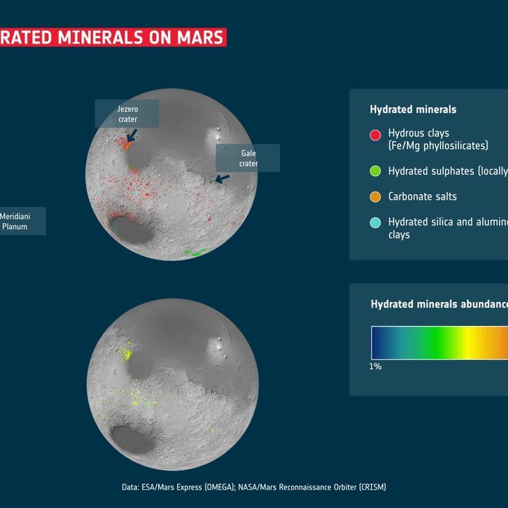
The map shows not only the locations of these minerals but also how abundant they are. And one of the biggest findings is that these minerals aren’t rare — in fact, there are hundreds of thousands of patches of minerals across the planet.

Recommended Videos

“This work has now established that when you are studying the ancient terrains in detail, not seeing these minerals is actually the oddity,” one of the researchers, John Carter, said in a statement.

This map is useful for assessing potential landing sites for future missions, whether crewed or robotic. Human crews will need to access water for a long-term Mars mission, and one way to do that is to bake aqueous minerals to extract the water they contain. But the clays are of scientific interest for robotic missions as well, as they are great for looking for signs of ancient life.

Studying how these minerals are spread across Mars helps us understand the planet’s history as well. Researchers are still debating exactly how long liquid water was present on the planet’s surface, and exactly what caused the planet to lose its water. This water map shows how complex that change was.

“I think we have collectively oversimplified Mars,” Carter said. “The evolution from lots of water to no water is not as clear cut as we thought, the water didn’t just stop overnight. We see a huge diversity of geological contexts, so that no one process or simple timeline can explain the evolution of the mineralogy of Mars. That’s the first result of our study. The second is that if you exclude life processes on Earth, Mars exhibits a diversity of mineralogy in geological settings just as Earth does.”

Please enable Javascript to view this content

Georgina Torbet
Georgina has been the space writer at Digital Trends space writer for six years, covering human space exploration, planetary…
Take a flight over Mars’ Ares Vallis in a new video from Mars Express
mars ares vallis flyover screenshot 2024 11 30 234209

A new video shows what it would be like to cruise over the surface of Mars, zooming in to the planet from orbit and into a channel called the Ares Vallis. Created from data taken by the European Space Agency's (ESA) Mars Express mission, it shows the region where NASA's Pathfinder mission landed in 1997.

Fly around Ares Vallis on Mars

Read more
Check out this incredible panorama of Mars taken by Curiosity
NASA’s Curiosity captured this panorama using its Mastcam while heading west away from Gediz Vallis channel on Nov. 2, 2024, the 4,352nd Martian day, or sol, of the mission. The Mars rover’s tracks across the rocky terrain are visible at right.

The Curiosity rover has been on Mars since 2012, and in that time it has driven more than 20 miles -- which might not sound like a lot, but is a long distance for a rover traveling at slow, careful speeds that are somewhat less than the average garden snail. The rover has now reached the end of an area it has been exploring for the past year -- a channel called Gediz Vallis -- but before it moved on, the rover snapped a series of images of the area, which you can explore in this NASA panorama:

Curiosity Rover Leaves Gediz Vallis Channel (360 View)

Read more
Planetary defense mission Hera blasts off toward Mars
Hera will perform a swingby of Mars in March 2025 as a way of gathering extra momentum on its way to the Didymos binary asteroid system. The spacecraft will fly within the orbits of both Martian moons Deimos and Phobos, and perform science observations of the former body and the planet's surface, in synergy with the UAE's Hope orbiter and gathering preparatory data for JAXA-DLR's MMX Martian Moons eXploration mission due to be launched in 2026.

The European Space Agency (ESA)'s planetary defense mission, Hera, has completed the first major maneuver of its journey following its launch in October. The spacecraft has burned its thrusters to put it on a course toward Mars, which it should reach to perform a gravity assist flyby in 2025.

The mission is a follow-up to NASA's DART mission, which deliberately crashed into an asteroid in 2022. DART was testing to see whether impacting a spacecraft into an asteroid could alter its trajectory, which it succeeded in doing. The idea is that if an asteroid should ever threaten Earth, space agencies could send a spacecraft to crash into it and knock it off course.

Read more