
New images reveal more about the history of water on Mars

This image from ESA’s Mars Express shows a dried-up river valley on Mars named Nirgal Vallis. This oblique perspective view was generated using a digital terrain model and Mars Express data gathered on November 16, 2018, during Mars Express orbit 18818. ESA/DLR/FU Berlin

Two new sets of images from NASA and the European Space Agency (ESA) have revealed more about the history of water on Mars. Scientists believe that billions of years ago, Mars had a thick, dense atmosphere that trapped heat and allowed liquid water to exist on the surface. They want to learn more about this period to see if there is any way that liquid water might still exist on the planet today.

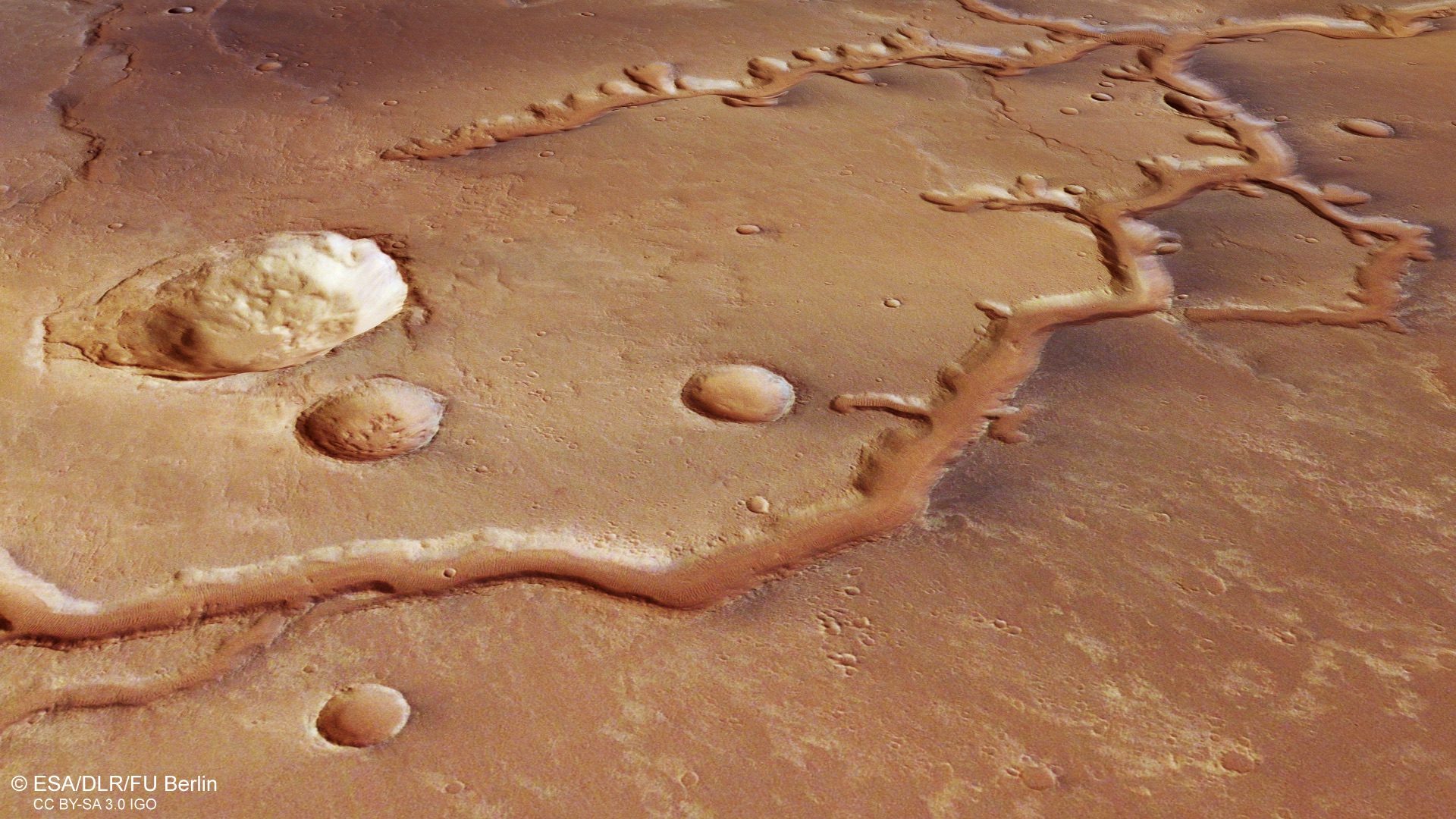
Above is an image that was taken by the ESA’s Mars Express, a spacecraft in orbit around the planet that has captured a dried-up river system called Nirgal Vallis located just south of the equator. The river system stretches for nearly 700 kilometers (435 miles) and was shaped both by the flow of water through the rock and by impacts when meteorites hit the surface. You can see the tree-like branching caused by the river’s flow as well as the round craters caused by the impacts. The system is believed to be between 3.5 and 4 billion years old.

The network of cracks in this Martian rock slab called “Old Soaker” may have formed from the drying of a mud layer more than 3 billion years ago. The view spans about 3 feet (90 centimeters) left-to-right and combines three images taken by the MAHLI camera on the arm of NASA’s Curiosity Mars rover. NASA/JPL-Caltech/MSSS

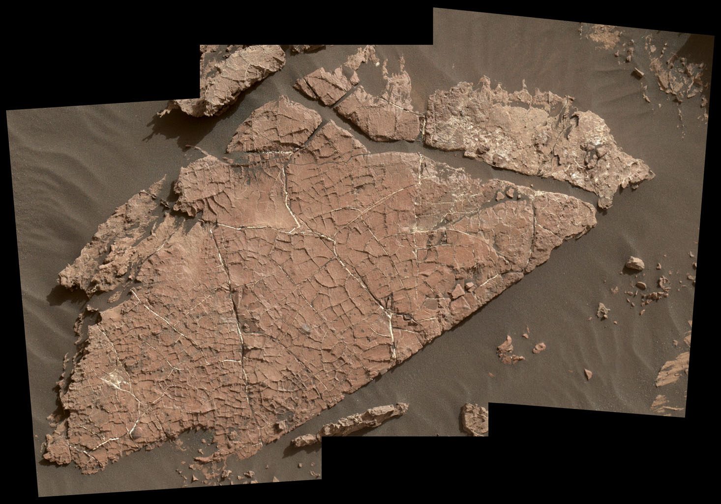
Around the same time, 3.5 billion years ago, the surface of the Gale Crater was very different too. This crater, also located near the equator, is where the Curiosity rover is currently exploring. The rover has captured this image of a network of cracks in the ground, suggesting there was once mud in this location which cracked as it dried. This provides further evidence that there were once lakes in this area.

Located within the Gale Crater is the massive Mount Sharp, which Curiosity is slowly climbing. The steep sides of the mountain allow scientists to view different layers of bedrock, learning about the Martian environment over time. The rover is currently in an area called the “clay-bearing unit” because of the presence of clay minerals there, but it will soon be moving on to the “sulfate-bearing unit.” There appear to be different layers in this new area, which could have formed in drier conditions which came later in Mars’ history.

In the next few years, Curiosity will make its way through the sulfate-bearing unit to investigate these layers up close, with the hopes of understanding how they fit into the environmental history of Mars.

Georgina Torbet
Georgina is the Digital Trends space writer, covering human space exploration, planetary science, and cosmology. She…
NASA’s Mars helicopter is about to attempt a colossal flight
NASA's Ingenuity Mars Helicopter acquired this image using its navigation camera. This camera is mounted in the helicopter's fuselage and pointed directly downward to track the ground during flight. This image was acquired on Oct. 24, 2021 (Sol 241 of the Perseverance rover mission) at the local mean solar time of 12:34:15.

NASA’s Mars helicopter is attempting its longest-ever flight this weekend. In fact, if you’re reading this on Sunday, the Ingenuity aircraft could be zipping across the martian surface at this very same moment.

NASA’s Jet Propulsion Laboratory will confirm the success of the flight just as soon as all of the data has come in.

Read more
NASA stops speaking to its Mars robots, but they haven’t fallen out
NASA's Perserverance Mars rover.

NASA’s Mars robots receive their commands from the mission team at the Jet Propulsion Laboratory in Southern California, but for the next few weeks, communications will fall silent.

This is due to that massive fireball in the sky -- aka the sun -- coming between Earth and Mars. The celestial event is known as solar conjunction and happens every couple of years.

Read more
Map of Mars shows the location of ice beneath the planet’s surface
In this artist’s concept, NASA astronauts drill into the Martian subsurface. The agency has created new maps that show where ice is most likely to be easily accessible to future astronauts.

One of the challenges of sending human explorers to Mars is that, due to the logistics of the journey, they will have to be on the planet's surface for considerably longer than the missions of a few days which have been sent to the moon in the past. That means future explorers will need access to resources like food, water, and oxygen -- and rather than having to carry months' worth of supplies through space, it's far more efficient to find ways to produce those resources on Mars itself.

That's the idea behind searching for water ice deposits on Mars. There's plenty of ice on the surface around the planet's poles, but most mission concepts are more focused on the planet's equatorial region. The good news is that there is ice present in these areas too, but the bad news is that it's primarily located below the surface and is thus hard to locate.

Read more