
Otherworldly Mars image shows ripples sculpted by dust devils

The European Space Agency (ESA) has released a hauntingly beautiful image of the surface of Mars, showing how the landscape there is sculpted by winds.

The image, taken from orbit by the ESA and Roscosmos ExoMars Trace Gas Orbiter (TGO), shows the Hooke Crater area in the southern highlands of Mars. The false colors are due to the filters used by TGO’s CaSSIS camera, which looks in the infrared wavelength to capture more details of the surface mineralogy.

Related Videos
A fascinating and otherworldly landscape near Hooke Crater in Mars’ southern highlands.
Chaotic mounds, wind-sculpted ripples, and dust devil tracks: This image shows a fascinating and otherworldly landscape near Hooke Crater in Mars’ southern highlands. The image was taken by the CaSSIS camera onboard the ESA/Roscosmos ExoMars Trace Gas Orbiter (TGO) on February 1, 2021, and shows part of Argyre Planitia, centered at 46.2°S/318.3°E. ESA/Roscosmos/CaSSIS

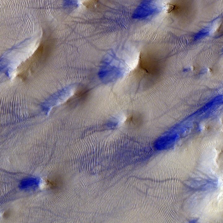
This unusual-looking scenery is par for the course on Mars, where the thin atmosphere, high winds, and large amounts of dust combine to create striking features on the surface.

“This type of scenery is similar to ‘chaotic terrain’: A kind of broken, disrupted terrain seen across Mars where haphazard groups of variously sized and shaped rocks — irregular knobs, conical mounds, ridges, flat-topped hills known as mesas — clump together, often enclosed within depressions,” the European Space Agency explains. “There are around 30 regions of chaotic terrain defined on Mars (see ESA Mars Express views of Ariadnes Colles, Pyrrhae Regio, and Iani Chaos for just a small sample); while this small patch has not been defined as one of these, its appearance is certainly chaotic.”

Close-up image of the false-colored contrast (blue) indicating whorls from dust devils and canyons.
ESA/Roscosmos/CaSSIS

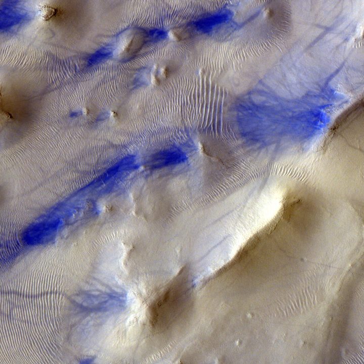
When seen up close, you can see the blue-tinted tendrils stretching out across the image. These are the tracks of dust devils, whirlwinds which are like tiny tornadoes and are common on Mars. When hot air at the surface of the planet rises quickly through cooler air above it, it forms an updraft that can begin to rotate and create a dust devil. This spinning column of air travels across the planet’s surface, leaving the distinctive tracks, before petering out.

ESA notes that the tracks seen in this image appear to travel on a north-south orientation, which could be the result of local winds blowing in that direction. Learning more about the <artian weather, including its winds, is the major focus of one of the instruments aboard NASA’s Perseverance rover. The MEDA instrument collects data on wind speed and direction, temperature, humidity, and the amount of dust in the atmosphere in order to better understand the martian weather system.

Editors' Recommendations

NASA declares Mars InSight lander mission officially over
This illustration shows NASA's InSight spacecraft with its instruments deployed on the Martian surface.

Just over four years after reaching Mars, NASA has officially announced the end of its InSight lander mission.

The declaration came on Wednesday, December 21, after NASA failed to make contact with the lander across two consecutive attempts, leading the mission team at the Jet Propulsion Laboratory (JPL) to conclude that InSight’s solar-powered batteries had run out of energy, a state referred to as “dead bus.”

Read more
Final messages from NASA’s Mars lander will bring a tear to your eye
A view from NASA's InSight lander showing its wind and thermal shield covering some of its science instruments.

The last image from NASA's InSight lander shows the wind and thermal shield covering some of its science instruments. NASA

It’s been known for some time that NASA’s InSight Lander was coming to the end of its operations on Mars after four years of service. And it looks as if its final communication with Earth has just taken place.

Read more
James Webb survey image shows a field of shining galaxies
A swath of sky measuring 2% of the area covered by the full moon was imaged with Webb’s Near-Infrared Camera (NIRCam) in eight filters, and with Hubble’s Advanced Camera for Surveys (ACS) and Wide-Field Camera 3 (WFC3) in three filters that together span the 0.25 to 5 micron wavelength range. This image represents a portion of the full PEARLS field, which will be about four times larger.

As well as providing new information about objects like exoplanets and giving new views of some famous space scenes, the James Webb Space Telescope is also being used to observe large patches of the sky in wide-scale surveys. Researchers from one such Webb survey, called the Prime Extragalactic Areas for Reionization and Lensing Science or PEARLS, recently released their first results showing an area of the sky called the North Ecliptic Pole.

This image shows around 2% of the sky, as captured by both Webb's Near-Infrared Camera or NIRCam and the Hubble Space Telescope's Advanced Camera for Surveys. This is just a part of the PEARLS survey, but shows thousands of galaxies including some extremely distant ones. You can see a zoomable version of the image on the Webb website.

Read more