
Google begins integrating Waze’s real-time traffic reports into its Maps app

google begins integrating waze data

Following Google’s acquisition of socially sourced navigation app Waze back in June, the Mountain View company has now started to incorporate some of its data into Google Maps.

“Users of Google Maps for mobile will now benefit from real-time incident reports from Waze users,” VP of Google Maps Brian McClendon said in a blog post announcing the news. So when Wazers (yes, that’s the name given to members of the Waze community) report, for example, accidents, construction, and road closures on Waze, “the updates will also appear on the Google Maps app for Android and iOS in Argentina, Brazil, Chile, Colombia, Ecuador, France, Germany, Mexico, Panama, Peru, Switzerland, UK and the US.”google_maps_waze

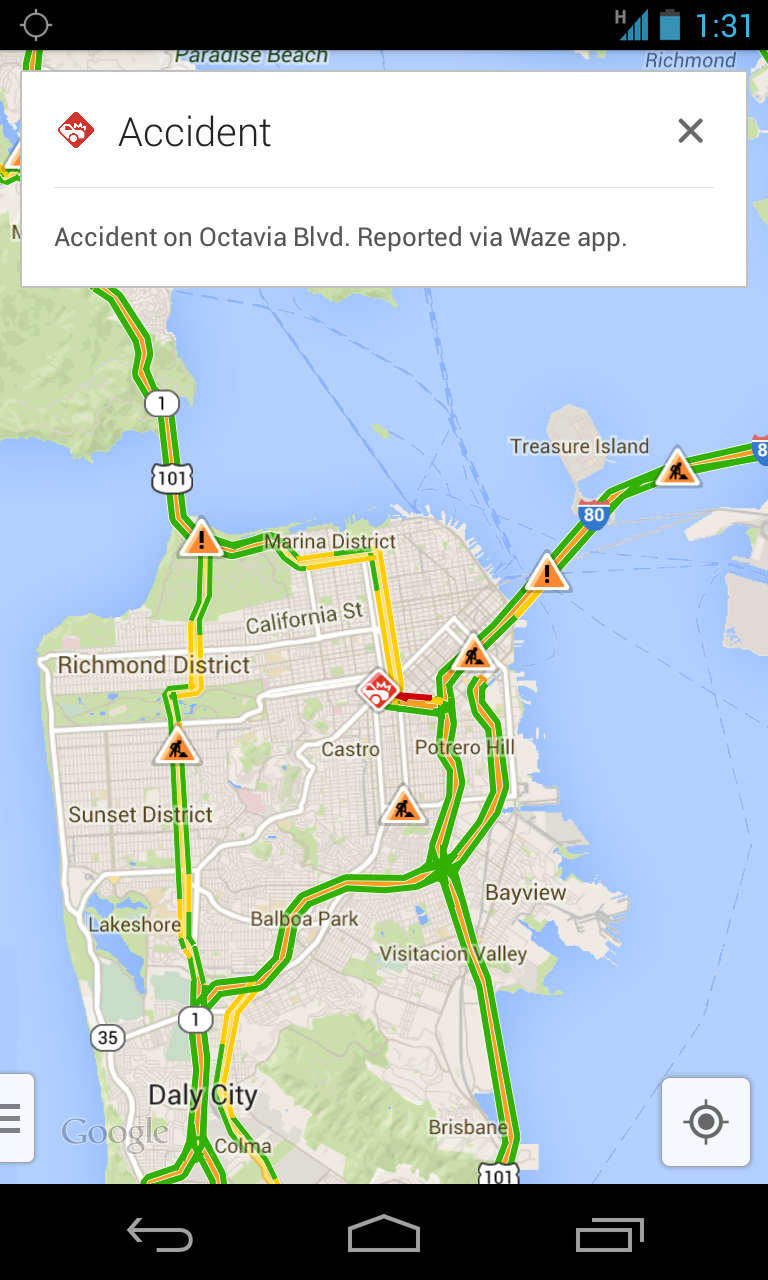
Users of the Waze app – of which there are said to be around 50 million – will also see some changes. Both the Android and iOS versions of the free app now incorporate Google Search, meaning Wazers  “will now have access to even more search results when navigating.”

Also, Street View and satellite imagery have been incorporated into the Waze Map Editor “to build out the map and make it easier to correct map errors reported by the community.”

With Maps now making use of Waze’s up-to-the-minute crowd-sourced traffic information, the app will suddenly prove itself to be a whole lot more useful for drivers using it to make their way around.

Waze gained a lot of exposure in September last year in the wake of Apple’s disastrous launch of its own Maps app. In an open letter to disgruntled users of the tech giant’s troubled maps offering, Apple boss Tim Cook suggested users give Waze a try. 

“While we’re improving Maps, you can try alternatives by downloading map apps from the App Store like Bing, MapQuest and Waze,” Cook said at the time. Nine months later, Google bought the company for around $1 billion.

Almost a year on, Apple Maps is showing signs of improvement, though it could be years before it catches up with Google’s broad offering. However, the battle for in-car dominance is certainly on, with the Cupertino company recently announcing iOS in the Car, an initiative involving a dozen automakers that will allow drivers to, for example, ask Siri for directions with the navigation results appearing on the vehicle’s LCD screen.

Editors' Recommendations

Trevor Mogg
Contributing Editor
Not so many moons ago, Trevor moved from one tea-loving island nation that drives on the left (Britain) to another (Japan)…
On Election Day, Google tracked nationwide voting issues on a real-time map
google voter issues map rsz img 20161110 230601

Google shined a light on an unfortunate, but nonetheless important, issue around Tuesday's election: voter suppression. As part of a collaboration with design studio Pitch Interactive, the Mountain View, California-based search company published a visualization of problems experienced by voters at polling stations nationwide.

Google's map, supplied with a combination of historical and real-time data from Google Trends, highlighted parts of the country where the electorate encountered resistance. Issues were categorized by relevance: problems with voting machines, long wait times, information on inactive voters, provisional ballot statuses, and voter intimidation. Each were designated on the map by circular, pulsating blips; the bigger the blip, the  larger the number of users in a given location conducted searches.

Read more
Google Apps for Education update will let parents see students' report cards
google tools for education cast quizzes feat

Google's serious about education. The reason? Schools seem serious about Google. Toward the end of last year, sales of the Mountain View, California-based company's Chromebook-branded computers accounted for more than half of all devices sold for U.S. grades K-12. It's no wonder, then, the Google continues to iterate on its classroom software melange of tools, services, and edutainment in recent months, and August marked another step in that pedagogical effort. On Wednesday, Google announced an Apps for Education update that includes a student progress summary, enhanced annotation, and myriad features more.

First up is a feature sure to prompt uncomfortable conversations at some kitchen tables: student progress reports. Parents or guardians, once invited by a teacher, can view a digest of classroom announcements, upcoming assignment due dates, and more. Summaries are sent in the form of an email every week or day, depending on preference, though particularly overbearing moms and dads can check historical reports at the times of their choosing.

Read more
Google's planning a big expansion of its Project Tango mapping tech
Project Tango

Don't look now, but Google's getting even more serious about virtual reality. After creating a division dedicated to researching it, adding support within its mobile operating system, Android, for it, and readying a stand-alone headset that'll deliver it, the search giant's planning a major content push: mapping real-life environments that can be explored within VR. According to Bloomberg, Google will introduce new tools to help developers capture the interiors of buildings by way of Project Tango, its depth-sensing development kit.

Google's plan, which the company will elucidate during four separate Project Tango sessions next week, involves a "big expansion" of the technology underlying Tango. Specifically, the company hopes that Tango, which uses cameras, infrared sensors, and specialized software to produce intricately detailed, three-dimensional recreations of the objects and spaces around it, will see widespread adoption among developers, video game programmers, and even grocery store chains and museums. One use case? An app that could "highlight sale items" and "guide shoppers to the right shelf," or a guided visual tour through an art gallery.

Read more