
See the crater scar left on Mars by an ancient impact

The surface of Mars is dotted with craters, created when asteroids, meteoroids, or comets smashed into the planet and caused large impact marks. Unlike Earth, which has relatively few impact craters because of its tectonic processes, on Mars, these craters remain for billions of years.

An image of one such crater was captured from orbit by the European Space Agency (ESA)’s Mars Express spacecraft on April 25, 2022, and was just recently released. The image shows a large crater, nearly 19 miles across, in a region called Aonia Terra.

This image from ESA’s Mars Express shows part of the scarred and colourful landscape that makes up Aonia Terra, an upland region in the southern highlands of Mars.
This image from ESA’s Mars Express shows part of the scarred and colorful landscape that makes up Aonia Terra, an upland region in the southern highlands of Mars. ESA/DLR/FU Berlin, CC BY-SA 3.0 IGO

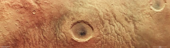
The landscape around the crater shows channels gouged into the surface, which were likely created when water flowed in rivers across Mars billions of years ago. “The channels appear to be partly filled with a dark material, and in some places, seem to actually be raised above the surrounding land,” ESA writes. “There are a variety of possible explanations for this. Perhaps erosion-resistant sediment settled at the bottom of the channels when water flowed through them. Or perhaps the channels were filled in with lava later on in Mars’ history.”

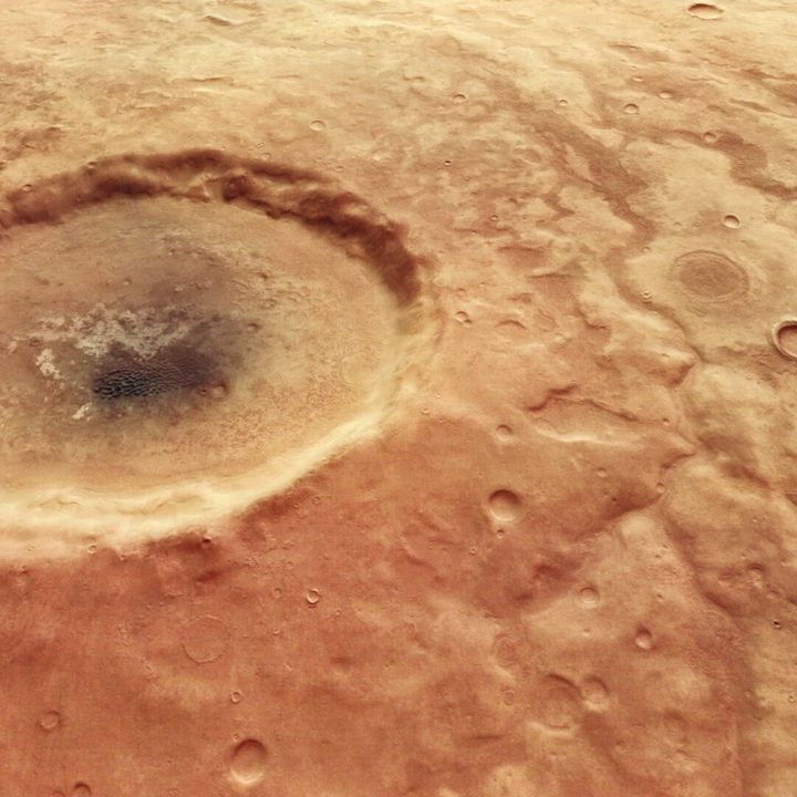
The image was taken using Mars Express’s High Resolution Stereo Camera (HRSC), and is a true-color image meaning it shows what a human eye would see. The data collected was also used to create a 3D terrain model, which allowed researchers to generate a view of the crater from a different angle as well:

The scarred and colorful landscape that makes up Aonia Terra, an upland region in the southern highlands of Mars.
This oblique perspective view of part of the scarred and colorful landscape that makes up Aonia Terra, an upland region in the southern highlands of Mars, was generated from the digital terrain model and the nadir and color channels of the High Resolution Stereo Camera on ESA’s Mars Express. ESA/DLR/FU Berlin, CC BY-SA 3.0 IGO

Studying impact craters is important as it allows scientists to estimate the geological ages of various features on the planet. The Aonia Terra region in the southern hemisphere is an excellent place for such research as it boasts many large craters, including the Lowell crater which is over 120 miles across.

The Lowell crater is named after Percival Lowell, an astronomer in the 1800s who famously thought that he observed canals on Mars, leading to an explosion of interest in the idea of life on Mars among the public. Although his theories were disproven and his observations turned out to be optical illusions, Lowell continues to have an influence both in science fiction writing and on science thanks to his passion for building observatories.

Editors' Recommendations

Georgina Torbet
Georgina is the Digital Trends space writer, covering human space exploration, planetary science, and cosmology. She…
Mars Odyssey spacecraft pulls a sideways maneuver to capture the planet’s horizon
NASA Orbiter Snaps Stunning Views of Mars Horizon

A new image from a NASA orbiter shows an unusual view of Mars that captures the planet's horizon complete with clouds. It is similar to the kinds of views of Earth that astronauts get from the International Space Station, showing what Mars would look like if seen from a similar vantage point.

The image was taken by NASA's Mars Odyssey spacecraft, which has been orbiting the planet since 2001. In its over 20 years of operations, the orbiter made key discoveries, including some of the first detections of subsurface ice on the planet. It has also created a global map of the planet's surface using its Thermal Emission Imaging System (THEMIS) instrument.

Read more
The Curiosity rover reaches a milestone on Mars
Curiosity Rover

NASA's Curiosity rover, which is currently exploring Mars' Gale Crater, recently marked an impressive milestone: 4,000 days on Mars. The rover landed more than a decade ago on August 5, 2012, and since then it has continued to explore the area, collect rock samples, and make its way up the epic slopes of Mount Sharp.

The 4,000 days are measured in mission time, which is calculated in martian days or sols. Due to the differing rates of rotation of Earth and Mars, a day on Mars is slightly longer than a day on Earth, by about 40 minutes. And also, due to the difference distances between Earth and Mars and the sun, a martian year is longer too - at 668 sols, equivalent to 687 Earth days. Those working on Mars rover missions, especially the rover drivers, have to operate on Mars time, so their schedules are out of sync with typical Earth working hours and they generally work on 90-sol shifts to allow them time to readjust to Earth schedules.

Read more
Map of Mars shows the location of ice beneath the planet’s surface
In this artist’s concept, NASA astronauts drill into the Martian subsurface. The agency has created new maps that show where ice is most likely to be easily accessible to future astronauts.

One of the challenges of sending human explorers to Mars is that, due to the logistics of the journey, they will have to be on the planet's surface for considerably longer than the missions of a few days which have been sent to the moon in the past. That means future explorers will need access to resources like food, water, and oxygen -- and rather than having to carry months' worth of supplies through space, it's far more efficient to find ways to produce those resources on Mars itself.

That's the idea behind searching for water ice deposits on Mars. There's plenty of ice on the surface around the planet's poles, but most mission concepts are more focused on the planet's equatorial region. The good news is that there is ice present in these areas too, but the bad news is that it's primarily located below the surface and is thus hard to locate.

Read more