
See the first images from Europe’s Sentinel-2C satellite looking down on Earth

Seville from Copernicus Sentinel-2C
Launched on 5 September 2024 on a Vega rocket from Europe’s Spaceport in French Guiana, the Copernicus Sentinel-2C satellite has delivered its first images. These spectacular views of Earth offer a sneak peek at the data that this new satellite will provide for Copernicus – Europe’s world-leading Earth observation programme. One of these first images, captured on 13 September, features a clear view of Seville and surroundings in southern Spain. contains modified Copernicus Sentinel data (2024), processed by ESA

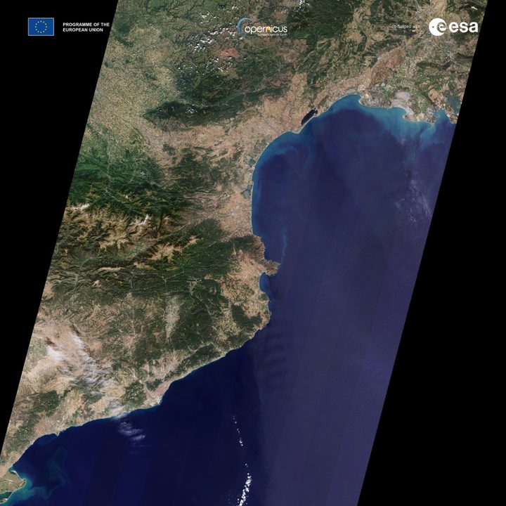
Earlier this month, the European Space Agency (ESA) launched its newest Earth-observation satellite, known as Copernicus Sentinel-2C. Joining its siblings Sentinel-2A and B, it will take high-resolution images of the planet’s surface from its altitude of almost 500 miles, capturing some stunning views of lesser-seen parts of our world.

Now, the first images taken by Sentinel-2C have been released, including views over European cities, a stretch of the French coast, and the effects of the wildfires raging through California. “These initial images stand as a powerful testament to the success of this extraordinary mission,” said Simonetta Cheli, ESA’s director of Earth Observation Programmes, in a statement. “While Sentinel-2 will continue to serve Copernicus with distinction for years to come, we are already looking ahead as we develop the next chapter with the Sentinel-2 Next Generation mission.”

France–Spain strip from Sentinel-2C
France-Spain strip seen from Sentinel-2C contains modified Copernicus Sentinel data (2024), processed by ESA

The satellite will be used for functions like tracking agriculture by looking for signs of crops or drought, monitoring water quality from space, and managing natural disasters like wildfires, floods, or volcanic eruptions. The effects of recent wildfires in California can be seen in two images below, which show natural color and false color versions of the area south of Los Angeles around the Airport fire, taken on September 12. The image on the left shows the spreading smoke, while the image on the right shows both active fires and areas that have already been burned.

With the first images in from the satellite, the engineers on the project will now spend the next three months calibrating the instruments to get even greater precision.

Recommended Videos

“We are thrilled to see the Copernicus Sentinel-2C already capturing such breathtaking images of Earth so soon after its launch,” said Constantin Mavrocordatos, Sentinel-2 Project Manager at ESA. “This is just the beginning of the incredible insights and detailed data it will provide, helping us better understand our planet.”

Georgina Torbet
Georgina has been the space writer at Digital Trends space writer for six years, covering human space exploration, planetary…
This infrared Earth image looks like a work of art
A near-infrared image of Kenya and Tanzania.

You only have to switch to Satellite View on Google Maps to see how beautiful Earth looks from up high, but images from spacecraft capturing data in the near-infrared channel also create images of stunning beauty.

Take this one (below) captured earlier this year by the Copernicus Sentinel-2 mission and shared a few days ago by the European Space Agency.

Read more
See the stunning first images taken by the dark matter-hunting Euclid telescope
The Horsehead Nebula, also known as Barnard 33, is part of the Orion constellation. About 1,375 light-years away, it is the closest giant star-forming region to Earth. With Euclid, which captured this image, scientists hope to find many dim and previously unseen Jupiter-mass planets in their celestial infancy, as well as baby stars.

The European Space Agency (ESA) has released the first full-color images taken by Euclid, a space telescope that was launched earlier this year to probe the mysteries of dark matter and dark energy. Euclid will image a huge area of the sky to build up a 3D map of the universe, helping researchers to track the dark matter that is clustered around galaxies and the dark energy that counteracts gravity to push galaxies apart.

The Horsehead Nebula, also known as Barnard 33, is part of the Orion constellation. About 1,375 light-years away, it is the closest giant star-forming region to Earth. With Euclid, which captured this image, scientists hope to find many dim and previously unseen Jupiter-mass planets in their celestial infancy, as well as baby stars. ESA/Euclid/Euclid Consortium/NASA, image processing by J.-C. Cuillandre (CEA Paris-Saclay), G. Anselmi; CC BY-SA 3.0 IGO

Read more
Here’s the first image of OSIRIS-REx as it approaches Earth with asteroid sample
This artist’s concept shows NASA’s OSIRIS-REx spacecraft descending towards asteroid Bennu to collect a sample of the asteroid’s surface.

This weekend will see the landing of NASA's first asteroid sample return mission, OSIRIS-REx. The spacecraft visited asteroid Bennu to study, photograph, and scoop up a sample from it, and now OSIRIS-REx is on it's way back to Earth and is almost here.

On Sunday, September 24, the spacecraft will release the capsule containing the sample, which will land in the Utah desert, where researchers will collect it for study. The spacecraft itself will continue on to study another asteroid, Apophis, and be rechristened OSIRIS-Apex.

Read more