Earth Day, marked annually on April 22, exists primarily to inspire the global population to work together to protect our planet from environmental harm. But it’s also a chance to celebrate everything that’s special about this unique and wonderful “blue marble.” With that in mind, take a moment to lose yourself in this collection of awe-inspiring Earth images, all of them shot from space.
1. Guinea-Bissau, West Africa
Taken by European Space Agency astronaut Thomas Pesquet during a stay aboard the International Space Station (ISS) around 250 miles above Earth, this image shows the coast of Guinea-Bissau in West Africa. NASA/ESA/Thomas Pesquet
2. Grand Erg Oriental, Algeria
Here we see the boundary between a major dune field and dark hills along the border between Algeria and Libya, as seen from the ISS. “These landscapes are among the driest parts of the Sahara Desert. For scale, the dune margin shown in this photo is slightly more than 62 miles (100 km) long,” the NASA's Earth Observatory says. NASA/EarthKAM/Earth Observatory
3. The Pearl-Qatar
While most of the shots in this collection show natural features, this eye-catching image shows an area dramatically transformed by humans. Captured from the ISS, it shows part of Doha, the capital city of Qatar in the Middle East, and also the Pearl-Qatar, an island built in the water. NASA/Earth Observatory
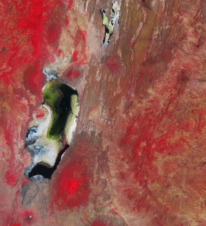
4. Australia
Another impressive image taken by Pesquet, this one shows a region of Australia, though the precise location isn’t specified. “I have never been to Australia, but the country is a constant supplier of three-star Earth Art,” the French astronaut said of the image, adding: “It is hard to judge from space if a landscape will be as amazing up close, but I definitely want to go and check regardless!” NASA/ESA/Thomas Pesquet
5. Himalayas
NASA astronaut Scott Kelly captured a lot of incredible Earth photos during multiple missions aboard the space station. This one shows a frozen lake in the Himalayas. NASA/Scott Kelly
6. Yukon Delta, Alaska
This one shows the Yukon Delta in the U.S. state of Alaska, captured during the European Space Agency’s Copernicus Sentinel-2 mission. “The sandy color of these channels and of the coastal water illustrates how much sediment the river carries to the sea at this time of year,” the Earth Observatory says. NASA
7. Mount Fuji, Japan
Peer down into the caldera of Japan’s iconic Mount Fuji, the country's tallest mountain at 12,389 feet (3,776 meters). Taken from aboard the ISS. NASA/Earth Observatory
8. Namib Desert, Southern Africa
This image shows the Roter Kamm crater (“red comb” or “red crest/ridge” in German), a feature about 430 feet (130 meters) deep and 1.5 miles (2.5 kilometers) in diameter. The crater, visible near the center of the picture, is believed to have been created by a car-sized meteorite that slammed into Earth around 5 million years ago. NASA
9. Cordillera Blanca mountain range, Peru
Peru’s snow-capped Cordillera Blanca mountain range on a misty winter morning, as seen from the ISS. The image includes Huascarán, Peru's tallest mountain, which soars 22,204 feet (6,768 meters) above sea level. NASA
10. Great Exuma Island, Bahamas
Looking more like painted art than a photo of Earth, this striking image shows small island cays in the Bahamas and the tidal channels that flow between them. The Earth Observatory describes the feature as “one of the most recognizable points on the planet” for astronauts gazing down at Earth. NASA/Earth Observatory/Scott Kelly
11. Namib Desert, Southern Africa
Another image featuring the Namib Desert, this one captured by Korea’s Kompsat-2 satellite. It shows the Namib Sand Sea and the blue and white dry river bed of the Tsauchab. ESA/KARI
12. Florida
The night lights of Florida, including part of the Florida Keys at the bottom right of the picture. Captured from the ISS, the image also shows the curvature of Earth. NASA
13. Lake Van, Turkey
NASA astronaut Kate Rubins shot this photo from the space station. It shows Turkey’s Lake Van, the largest soda, or alkaline, lake on Earth. While some parts of the lake are shallow, other parts can be up to 1,467 feet (450 meters) deep. “Lake Van water levels have changed by hundreds of meters over the past 600,000 years due to climate change, volcanic eruptions, and tectonic activity,” the Earth Observatory says. NASA/Earth Observatory/Kate Rubins
14. Aurora
A beautiful aurora captured by NASA astronaut Shane Kimbrough during a stay on the ISS. NASA/Shane Kimbrough
15. Yemen
Precambrian rocks (more than 540 million years old) and expansive dunes in Yemen’s interior, captured from the ISS. NASA/EarthKAM
16. Bahamas
Featuring seas near the Bahamas, this image was captured by Kimbrough from the space station. NASA/Shane Kimbrough
17. Richat Structure of Mauritania, Africa
This remarkable picture shows an uplifted dome where the rocks exposed in the center of the “bullseye” are older than those forming in the outer rings. The feature in the image is 28 miles (45 km) across and made up of igneous and sedimentary rocks. NASA/Earth Observatory
18. Sea and cloud
Earth seen from space, with oceans and clouds filling the frame. Kelly, who took the photo, titled it: "Out over the blue." NASA/Scott Kelly
19. Spain
Another stunning shot from Kelly taken during one of his visits to the space station. This one features colorful salt ponds in Spain. NASA/Scott Kelly
20. Sharq El Owainat, Egypt
Sahara Desert crop circles fill the frame in this odd-looking shot. The fields were created by a sprinkler system that rotates around a central point. It was captured by an astronaut aboard the ISS. NASA/Earth Observatory
21. Northwest Atlantic
Taken by an External High-Definition Camera (EHDC) on the ISS, this oblique image looks toward the sunlight of dawn as the station passed over the northwest Atlantic Ocean, about 300 miles (500 km) off the coast of Nova Scotia, Canada. “Numerous small clouds cover the foreground of the image. Each cloud represents in visible form (due to water droplets) a rising column of air,” the Earth Observatory says. NASA/Earth Observatory
22. Nile River, Egypt
Captured by an ISS astronaut as the station passed over Egypt, this photo shows a heart-shaped basin bordering the Nile River and the Western Desert. The Faiyum Oasis, as the basin is known, spreads across more than 450 square miles (1,200 square km) and was formed from the ancient lakebed of Lake Moeris. NASA/Earth Observatory
23. Shanghai at night
The Chinese metropolis of Shanghai at night, captured by Kelly. The Huangpu River is clearly visible, and if you look very closely, you may even be able to spot the city's iconic Oriental Pearl Tower. NASA/Scott Kelly
24. Earth
Earth, as seen from the moon, in an image captured during the historic Apollo 11 mission that put the first humans on the lunar surface in 1969. NASA