
See the first image of Earth from a new weather-monitoring satellite

A recently launched weather satellite has sent back its first image of Earth, showing our planet in gorgeous detail. The European Meteosat Third Generation Imager-1 was launched in December of last year with the aim of monitoring weather conditions across Europe and Africa, and it took this image from its location 22,000 miles above the Earth’s surface.

The image was taken using the high-resolution Flexible Combined Imager instrument in March 2023, showing the areas of cloud and clear skies that can be seen over the Atlantic Ocean, as well as the European and African land masses.

First image of the full Earth disc from the Meteosat Third Generation Imager. The first image from Meteosat Third Generation – Imager 1 (MTG-I1) reveals a level of detail about the weather over Europe and Africa not previously possible from 36 000 km above Earth. The higher-resolution images provided by the instruments on board give weather forecasters more information about the clouds cloaking much of Europe and visible in the equatorial region of Africa and the Atlantic Ocean. Sand and sediment in the waters off Italy are also visible, as well as dust or smog being carried from south Asia. This degree of detail is not possible from the instruments on the Meteosat Second Generation satellites. The image was captured at 11:50 UTC on 18 March 2023 by the Flexible Combined Imager on MTG-I1.
The first image from the Meteosat Third Generation Imager-1 reveals a level of detail about the weather over Europe and Africa not previously possible from 22,000 miles above Earth.  EUMETSAT/ESA

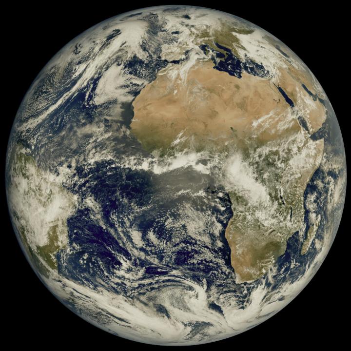
The instruments on the Meteosat (MTG) are of a higher resolution than previous tools, as it is the first of a new generation of European weather satellites. This higher resolution allows weather features like clouds to be tracked more accurately, while also offering a view of how weather systems move across this part of the globe.

That will help with weather forecasting and dealing with extreme weather conditions such as hurricanes, according to the MTG team. “This remarkable image gives us great confidence in our expectation that the MTG system will herald a new era in the forecasting of severe weather events,” said Phil Evans, director general of the European weather-monitoring satellite agency Eumetsat, in a statement.

“It might sound odd to be so excited about a cloudy day in most of Europe. But the level of detail seen for the clouds in this image is extraordinarily important to weather forecasters. That additional detail from the higher-resolution imagery, coupled with the fact that images will be produced more frequently, means forecasters will be able to more accurately and rapidly detect and predict severe weather events,” the team said.

The team says that data from the satellite will also help international weather forecasting and climate change monitoring. “The high-resolution and frequent repeat cycle of the Flexible Combined Imager will greatly help the World Meteorological Organization community to improve forecasts of severe weather, long-term climate monitoring, marine applications, agricultural meteorology, and will make an important contribution to the Early Warnings For All Initiative, in particular on the African continent,” said Natalia Donoho of the World Meteorological Organization.

Georgina Torbet
Georgina is the Digital Trends space writer, covering human space exploration, planetary science, and cosmology. She…
Two asteroids whipped past Earth last week, and researchers snapped images
The Goldstone Solar System Radar, part of NASA’s Deep Space Network, made these observations of the recently discovered 500-foot-wide (150-meter-wide) asteroid 2024 MK, which made its closest approach — within about 184,000 miles (295,000 kilometers) of Earth — on June 29.

The Goldstone Solar System Radar, part of NASA’s Deep Space Network, made these observations of the recently discovered 500-foot-wide (150-meter-wide) asteroid 2024 MK, which made its closest approach — within about 184,000 miles (295,000 kilometers) of Earth — on June 29. NASA/JPL-Caltech

The last week saw not one but two asteroids whip by Earth at close distances -- not so close as to threaten the planet, but close enough for scientists to get a good view of them. Asteroid hunters tracked the pair as they passed by, and they were even imaged by NASA instruments to learn more about asteroids, including those that could potentially threaten Earth in the future.

Read more
China makes history by returning the first sample from far side of the moon
This photo taken on June 25, 2024 shows the retrieval site of the return capsule of the Chang'e-6 probe in Siziwang Banner, north China's Inner Mongolia Autonomous Region.

This photo taken on June 25, 2024, shows the retrieval site of the return capsule of the Chang'e-6 probe in Siziwang Banner, north China's Inner Mongolia Autonomous Region. Xinhua/Jin Liwang

A Chinese space mission has made history by bringing the first lunar sample from the far side of the moon back to Earth. The Chang'e-6 mission landed on the moon's far side earlier this month, where it collected a sample that was returned to Earth on Tuesday, June 25.

Read more
Hubble takes first image since switching to new pointing mode
This NASA Hubble Space Telescope features the galaxy NGC 1546.

This NASA Hubble Space Telescope captured an image of the galaxy NGC 1546. NASA, ESA, STScI, David Thilker (JHU)

The Hubble Space Telescope has been through some troubles of late, and the way that it operates had to be changed recently to compensate for some degraded hardware. The telescope's three gyros, which help it to switch between different targets in the sky, have been experiencing issues, with one in particular frequently failing over recent months. NASA made the decision recently to change the way that Hubble points, and it now uses just one gyro at a time instead of all three in order to preserve the two remaining gyros for as long as possible.

Read more