
Google launches helicopter view in Google Maps

google-maps-3d
Image used with permission by copyright holder

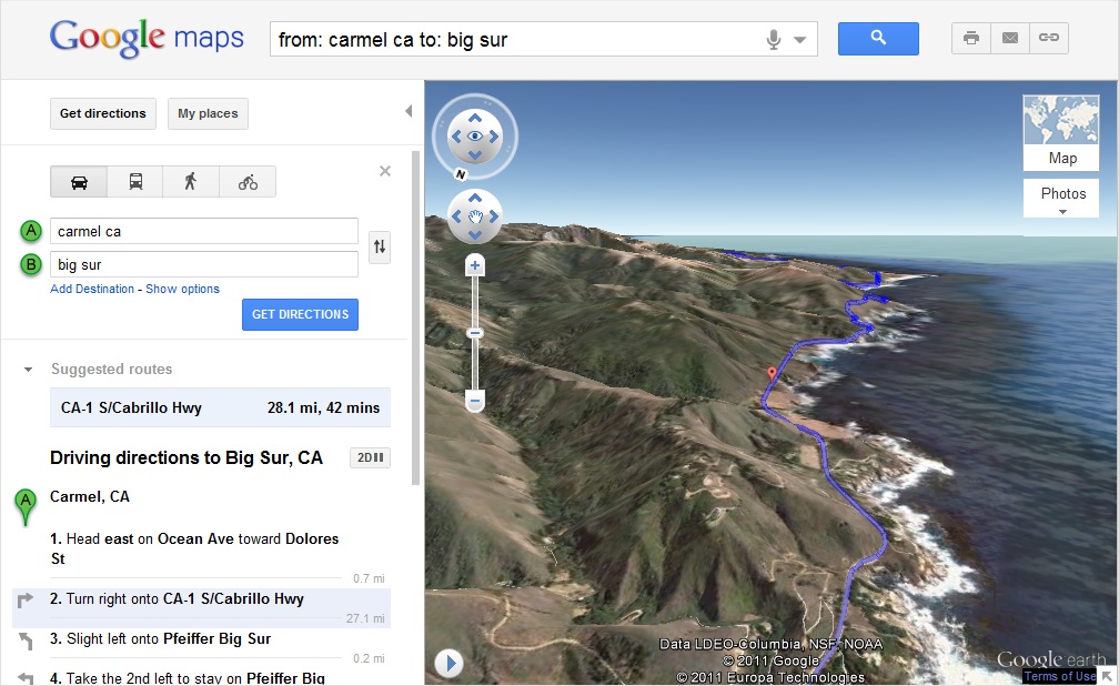
Earlier this week, Google added a new button to the Google Maps Web interface that allows the user to view a 3D birdseye view of the route. To utilize the new feature, simply plug in a start point and a end point to the directions section of Google Maps. After calculating the route, look for a “3D” button next to the text “Driving directions”. After pressing the new “3D” button, the map shifts into Google Earth view and begins navigating the route. The concept is similar to the Soarin’ Over California attraction at Disneyland’s California Adventure, a theme park ride that lifts people into the air and simulates a flight over scenic portions of California.

The 3D simulation of the route can be paused at any time and users can rotate the map exploring the terrain of the surrounding area. After resuming the simulated flight, users can view each leg of the trip by watching the highlighted section within the directions on the left side of the screen. Users can also jump to other sections of the trip by clicking on a specific section within the directions. Users can also pop back into 2D mode at any time during the animation. In addition to the 3D animation, users can also stop during the simulation to click on pictures and information links to learn more about the surrounding area or major landmarks.

The 3D helicopter view is currently being rolled out slowly across different regions and may not be available for all users yet. Google Maps recently received a bit of negative attention when criminals in Chicago used the service to satellite view to seek out expensive homes next to highways. Google Maps helped the man in question burglarize nine suburban homes and steal $100,000 worth of jewelry and electronics.

Editors' Recommendations

Topics
Mike Flacy
By day, I'm the content and social media manager for High-Def Digest, Steve's Digicams and The CheckOut on Ben's Bargains…
Google reveals how many miles its Street View cars have driven to date
street view cars pollution data car

As if you didn’t already know it, Google’s Street View cars have been going here, there, and everywhere since the first camera-equipped vehicle took to the streets more than a decade ago.

The web giant has just revealed that Street View has now captured more than 10 million miles of imagery from around the world, a distance which, if driven in a straight line, would circle Earth more than 400 times.

Read more
Google Maps expands voice guidance for blind and partially sighted users
google maps voice guidance detailed

In honor of World Sight Day, Google Maps has introduced a new feature for blind or partially sighted people. Maps will now offer more detailed voice guidance and verbal announcements to make navigating with limited vision easier and safer.

"As a legally blind woman living in Tokyo, I know that getting around unfamiliar environments can be a challenge," Google's Wakana Sugiyama wrote in a blog post. "I can easily commute from my front door to my desk at work; it’s a trip I take regularly and know well. But going someplace new and unfamiliar can be an intimidating experience without sight to guide you."

Read more
Google Maps insists it’s doing what it can to weed out business scammers
4 ways 2020 has changed how i use my tech google maps in hand

Google Maps’ long-running problem with fake listings has hit the headlines again. A report on Thursday, June 20 by the Wall Street Journal claimed that the service lists around 11 million businesses that are in some way false, and despite ongoing efforts, the web giant “can’t seem to stop the proliferation of fictional business listings and aggressive con artists on its search engine.”

Fake listings can pose a number of risks for people who use Google Maps to find services.

Read more