
 After the third or fourth missed turn on a solo motorcycle trip through Pennsylvania’s Pocono mountains, I realized Google Maps had screwed me. With no GPS or smartphone, I was relying on a crumpled up sheet of printed directions from Google Maps taped to my tank to navigate me to Philadelphia. And none of the street names matched the signs I saw.
Where Google told me to look for, say, State Route 3029, Ridge Road whizzed by on my right. Same road, but Google didn’t seem to know that at the time. With a dash of Boy Scout ingenuity (we learned it between hitting each other with sticks), I ended up using the miles between each turn as my last resort to identify the right roads. Without a working trip odometer, I had to mentally add each little fragment of mileage to the bike’s total mileage to spot each road I needed.
Thanks, Google.
That was 2007, but up until a couple of days ago, the Google Maps I used then and now weren’t all that different. That changed on Wednesday, when Google announced a new version of Google Maps, radically revamping the tool that millions of people rely on to get them across town, across the country, and across the world. But is the prettier new face any good, or is it still bound to leave you spun around and disoriented in Shamokin, PA? I went hands on to find out (but left the bike in the driveway).
All dressed up for a night of mapping the town
A well-designed map doesn’t just look sharp, it’s more functional – and Google’s new maps accomplish both. From a brighter color scheme to larger text, consistent icons, and little details like shading around bodies of water, everything about them looks better, and easier to understand as a result.


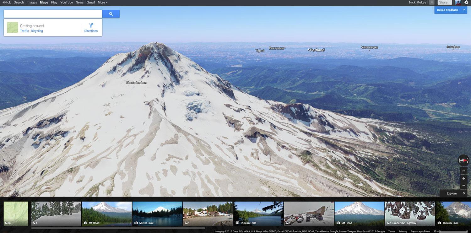
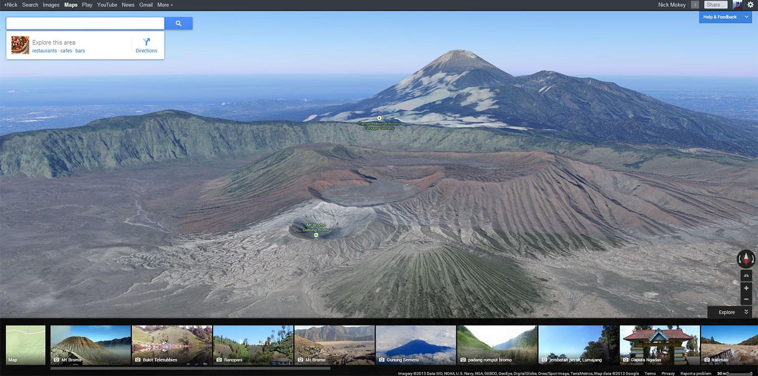
Techies will notice that Google Maps now uses the WebGL engine, which makes it load faster and opens the door for more advanced effects. You’ll notice improvements like more fluid zooming, and how the map reshapes on the fly as you zoom in and out at street level, rather than temporarily turning into pixely goo while Google downloads new imagery. The biggest boon, though, is gorgeous 3D imagery right within Google Maps. No more need to download Google Earth; you can get the same view in Maps with the click of a button. Google’s 3D imagery – if you haven’t checked it out in Earth recently – is unrivaled in its scale and accuracy. Forget skyscrapers – if you live near a major city, there’s a good chance your house is even in 3D.
Besides this major cleanup of the actual maps, the interface you use to interact with them has also been minimized and swept to the corners. The only clutter amounts to a search bar, a few scattered buttons, and Google’s usual control bar (Search, Images, Maps, etc.) striped across the top. The rest is big, beautiful map.
Seek and ye shall find
Searching for something – like Thai food – fills said map with both icons and place names, laid directly over the terrain rather than throwing down a handful of numbered pins and forcing you to look to a numbered “key” in a sidebar to interpret them. How did another company not do this first?
Rather than plain balloon-shaped pins, Google now uses icons to help you distinguish between different types of results. Searching for “fish” might turn up both seafood restaurants (a knife and fork icon) and fish markets (a shopping bag icon). At closer zoom levels, Google even squeezes in a few keywords alongside each icon (“mango sticky rice, salad rolls”) to give you an idea what to expect. If you want the detailed overview the way it used to appear, you can click “Go to list of top results” to see star ratings, prices, and phone numbers all at a glance.


- 1. Go to results
- 2. New version of Google Maps
- 3. Old version of Google Maps
After searching for something, you can choose to see results based on your Google+ Circles. In theory, this means you could, for example, search for something like “pizza” and see what your snide New Yorker friends prefer. In practice, none of my G+ friends had any preferences regarding anything I searched for. I’ll admit I haven’t spent much time searching people out in the empty halls of G+, but you would think one of 122 people would have something to say about where to get “food” or “coffee.” Nope. It’s possible this feature will gain traction as Google continues to shove its social network down our collective throats, but right now it sucks as much as Google+.
You can also filter search results by what Top Reviewers prefer, making it kind of like Google’s version of Yelp. Well, Google’s Malt-o-Meal to Yelp’s Rice Krispies. When it comes to crowdsourcing opinions, Yelp still reigns supreme. Top Reviewers make an easy way to weed out some fluff, but after a few side-by-side comparisons, we’d take Yelp’s advice over Google’s any day.
A map tailored to you
If you’ve seen any of Google’s promos for the new Maps, you’ll see it’s pushing hard on the idea that everything we see on Google Maps has now been personalized. “What if we told you that during your lifetime, Google could create millions of custom maps … each one just for you?” Google excitedly babbles on the Google Maps blog. Come on, Google. We all know there’s not a tiny man in our computer drawing each map by hand (though Foxconn could probably make that happen). Still sounds cool though, right?
Sort of. In practice, this basically means that Google will use your preferences to highlight other places it thinks you might like. If I click on a brewpub in Portland, half a dozen others pop up on the map in bold, selected based on what I’ve told Google I like with stars. In general, Google’s picks seemed pretty reliable: I didn’t star Deschutes Brewery to tell Google I like it, but Google made an accurate guess that it should be on my radar when I’m checking out Migration Brewing. It also helpfully shows icons for your home and work on the map, with drive or walk times to your destination of choice printed below.

Adding a star to an establishment flags it as a favorite and drops a star on the map for it. Google will try to show the name of it on all the maps it shows you, so after a while, the map really does start to feel like yours. But your preferences seem to have no effect on the other spots Google chooses to highlight. I’ve never searched for churches, guesthouses or elementary schools, but Google still sees fit to persistently highlight these on my map. Rather than just adding spots you like, it would be nice if Google could learn to hide items you clearly have no interest in to declutter the map.
Speaking of clutter, if Google expects users to continue building their preferences with stars, we need an option to turn the star icons off. Adding a star for every one of your favorite haunts is fun, and improves Google’s recommendations, but after a while the map starts to look like you spilled confetti all over it. Starring categories outside bars and restaurants creates an even bigger mess. For instance, I have about half a dozen auto parts stores I would like to see highlighted when my car is spewing gas all over the driveway, but I really don’t need to see them on the map at any other time. Google needs to find a less visible way to file these preferences away.
Where did it go?
 Like many “upgrades” that prioritize making things easier, some bells and whistles seem to have disappeared. For instance, both the “terrain” and “satellite” maps have gone missing, replaced by the new Earth view (a shame for hikers and bikers, since “terrain” gave a much better sense of elevation). The familiar Google Street View rag doll – which you could place anywhere on the map to see his perspective – has also gone MIA. Now you need to click a spot on the map, then click Street View in the upper left – if Google has imagery for it. There’s no way to get back the blue highlights which used to show which streets had Street View imagery and which didn’t. Even in areas that didn’t have it, you could previously see blue squares that indicated where you could see Panoramio pictures. Not anymore. You can still access these photos with the “Explore” tab on the bottom right, but you only have the option to pick a photo and see where it was taken, not pick a spot on the map and see what a photo from there looks like.
Taking transit just got less confusing
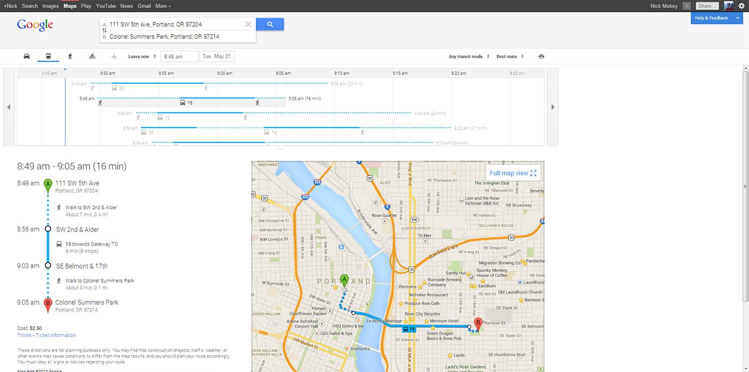 Anyone who uses Google Maps to hop busses, trains, and streetcars will be thrilled with the updates Google has made here, which make it easier than ever to see how to get where you’re going. After telling Google you want directions for public transportation, you can see all your different options laid out in a timeline, clearly illustrating how long you’ll need to walk, ride, and what time you’ll arrive. You can tweak the results by cutting out bus trips to just see train routes, for instance, or asking for trips that minimize walking or transfers. (These seemed glitchy during testing; Google still insisted on offering bus routes when we wanted to travel by train.) Clicking any of the potential maps redraws the map to show exactly where you would be going, with dots to identify walking and bright flags to identify different bus and train routes.
Conclusion
Apple may have taken a swing at Google Maps when it cut it from iOS, and open-source maps may be making strides by tapping the wisdom of the crowd, but Google remains the master of maps. From Street View to its aggressive 3D mapping, and now a gorgeous new user interface, Google has simply thrown more resources into this fight than any of its competitors. Boots on the ground matter when you’re literally trying to chart the world, and Google has plenty.
We’re sad to see terrain view and a few other features go, but, on the whole, Google Maps is faster, sleeker, and more usable now than ever. Though the new interface will take some getting used to for old salts, it offers enough benefits to justify the inconvenience.
And should you find yourself out in the boonies with only directions from Google, it now identifies those lonely rural roads with the name you’ll see on the sign. Yes, I checked.


