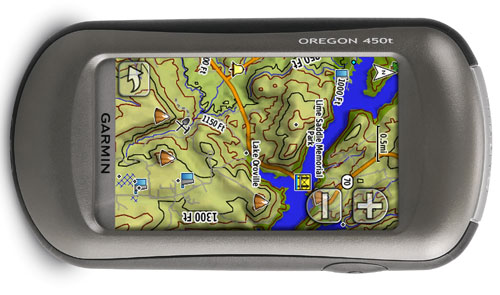
 GPS maker Garmin is aiming to please outdoor enthusiasts with the release of its Oregon 450 and Oregon 450t outdoor-friendly GPS systems designed for use in the woods, on the mountains, and out in the middle of nowhere. Both units feature a 3-inch 240 by 400-pixel touchscreen display, USB connectivity, an electronic compass, barometric altimeter, customizable dashboard screens, and support for the Garmin Connect online community as well as Custom Maps that make it easy to put paper or digital maps into the units.
“More than ever, Garmin offers intuitive touchscreen options for anyone exploring and enjoying the world around them,” said Garmin VP of worldwide sales Dan Bartel, in a statement. “Oregon 450t and Oregon 450 provide a bridge between the slimmed-down Dakota family and the top-of-line Oregon 550t, all of which work seamlessly with Garmin Custom Maps in planning your adventure and Garmin Connect for reliving the experience and sharing the memories.”
Both units feature a shaded relief map of the entire world, while the Oregon 450t asses topographic maps of the United States that world with a 3D elevation perspective feature and includes major trails, roads, coastlines, rivers, and lakes, along with parks, forests, and wilderness areas. Both units run on AA batteries (handy for swapping out whil away from power outlets), have 850 MB of onboard memory and a microSD expansion slot. Users can have the unit keep track of their activity and download the data afterward, then share their activities via Facebook, Twitter, Google Earth, and Garmin’s own Garmin Connect online community. And, the units should stand up to the rigors of outdoor use: the don’t float, but they are waterproof. And both units can share waypoints, tracks, routes, and things like geocache information wirelessly with other compatible Garmin Oregon, Dakota, and Colorado users: just press the “Send” button to transfer your information to compatible units.
The Oregon 450 carries a suggested retail price of $399.99; the 450t will go for $499.99. Garmin hasn’t said when the units will be available, but we’re betting “early 2010” is a safe bet.