  1. Home
  2. Space
  3. Emerging Tech
  4. News

This interactive 3D map of every object orbiting Earth is absolutely engrossing

Add as a preferred source on Google

Ever since the Soviet Union launched the Sputnik 1 in 1957, the human race grew an immense infatuation with shooting just about anything it could into orbit of the Earth. Today, with nearly 60 years of this behavior under our belt, the skies just outside Earth’s atmosphere have become quite congested.

Want some proof?

Recommended Videos

James Yoder, an incoming freshman at the University of Texas Austin, just published a site detailing every satellite, busted rocket, and piece of space junk currently orbiting Earth; and the finished product is utterly incredible. A simple trip to stuffin.space reveals an astounding map of the roughly 20,000 pieces of debris floating in space, as well as information pertaining to its launch year, velocity, altitude, and inclination. Clicking on any of the thousands of available dots reveals such information, and also displays the object’s orbiting flight path. Sandra Bullock would have been wise to check the site before suiting up in Gravity.

To make it easier to navigate — and wildly addicting — Yoder categorizes each piece of debris into three separate categories: red for satellites, blue for rocket bodies, and gray for debris. Looking for the camera Sunita Williams lost during her mission aboard the STS-116 in 2006? It’s likely one of the many gray dots scattered around the map. Though the information doesn’t specifically say what the debris is, the site does allow users to search for an object via its international designator code — because you know, who doesn’t have those handy?

The United States GPS satellite network
The United States GPS satellite network Image used with permission by copyright holder

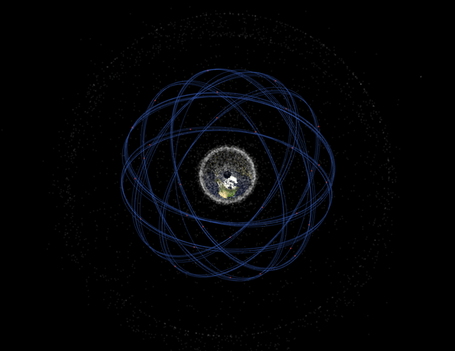
In addition to offering space object positioning data, Stuffin.space also provides independent flight paths of various groups, such as the satellite network responsible for GPS, as well as the massive payload delivery system, Ariane Sylda. When highlighted, the flight paths of these groups look like an incredibly artistic geometric group of roulette curves, or something you’d draw up using a Spirograph. Yoder even includes a group showing off the wreckage stemming from 2009’s Iridium 33 and Kosmos-2251 satellite collision. The hundreds — if not thousands — of pieces of debris cover Earth as if it were a ball of yarn. It’s thoroughly stunning.

Perhaps the website’s most incredible feature is the fact its creator commissioned this interactive, real-time map before even moving out of his parents’ house. An alumnus of the esteemed CRyptonite Robotics team at Cinco Ranch High School, Yoder plans to attend the University of Texas Austin this fall to study Electrical and Computer Engineering. I think it’s safe to say he’ll do perfectly well in the field considering he’s already created one of the most engrossing websites we’ve ever seen.

Rick Stella
Former Associate Editor, Outdoor
Rick became enamored with technology the moment his parents got him an original NES for Christmas in 1991. And as they say…
Scientists warn Elon Musk’s orbital data centers could blind Earth’s biggest telescopes
A new ESO study suggests millions of satellites could make parts of the night sky effectively unusable for astronomy.
One hour of satellites over the northern Atacama Desert in Chile (October 2025)

The race to blanket Earth with satellite internet has unlocked faster connectivity for millions. But according to the European Southern Observatory (ESO), it could also make one of humanity's oldest hobbies, and one of its most important sciences, a whole lot harder. The organization warns that the rapid growth of satellite mega-constellations could severely disrupt observations made by some of the world's most powerful telescopes.

Astronomers say the night sky is reaching its limit

Read more
Amazon’s Starlink rival just crossed a major milestone, but don’t expect perfect internet just yet
Amazon finally showed up to the space internet party
Amazon Leo satellite layout across all launch vehicles

Amazon has taken a significant step toward launching its long-awaited satellite internet service. Following its latest rocket launch, the company now has 396 Project Kuiper satellites in low-Earth orbit, enough to begin offering continuous service across select regions. The milestone keeps Amazon on track for its previously announced goal of launching commercial service by mid-2026.

https://twitter.com/Weber44Chris/status/2072575499461963938?ref_src=twsrc%5Etfw%7Ctwcamp%5Etweetembed%7Ctwterm%5E2072575499461963938%7Ctwgr%5Ed727a1b853cbf519585e7bf2655943afb2f91bb8%7Ctwcon%5Es1_&ref_url=https%3A%2F%2Fwww.theverge.com%2Fscience%2F960563%2Famazon-leo-service-tipping-point

Read more
Amazon’s Starlink rival is set to launch satellite internet later this year
After launching nearly 400 satellites, Amazon says its Leo broadband service will go live later this year.
Atlas V launches 29 Amazon Leo satellites from Cape Canaveral, Florida

Amazon's long-awaited answer to SpaceX's Starlink is finally nearing liftoff. According to an exclusive report from Reuters, the company plans to begin offering its Leo satellite internet service later this year, after its latest rocket launch pushed the constellation to 394 satellites in orbit.

The pieces are finally falling into place for Project Kuiper

Read more