
The USGS just released a set of high-res maps that show the topography of the moon

uses lunar maps usgs moon flat
USGS/NASA/ASU
Good news for all you armchair astronomers out there — the US Geological Survey just published a pair of highly detailed lunar maps that provide an unprecedented look at the moon’s surface,  allowing you to couch surf your way across moon craters, volcanoes and Apollo landing sites. The pair were assembled using information from NASA’s Lunar Reconnaissance Orbiter (LRO) spacecraft and recently published in high-resolution format on the USGS website for printing or download.

The stunning new maps replace the existing Lunar Chart (LPC-1), which was produced in 1979 as a series of airbrushed drawings based on existing telescopic and orbital lunar images. The chart was flat in design and did not provide any elevation data. The new maps, on the other hand, are derived directly from digital photographs and include both a photo mosaic of the moon’s surface and a topographic map that represents elevation data.

The photo mosaic uses images from LRO’s wide-angle camera and allows you to view prominent physical features such as craters and volcanoes on the moon’s surface. The topo map compiles the data obtained from the Lunar Orbiter Laser Altimeter (LOLA) which was installed on the LRO to collect elevation data. It represents lunar elevation in a gradient where blue is a low altitude and gray is a high altitude.

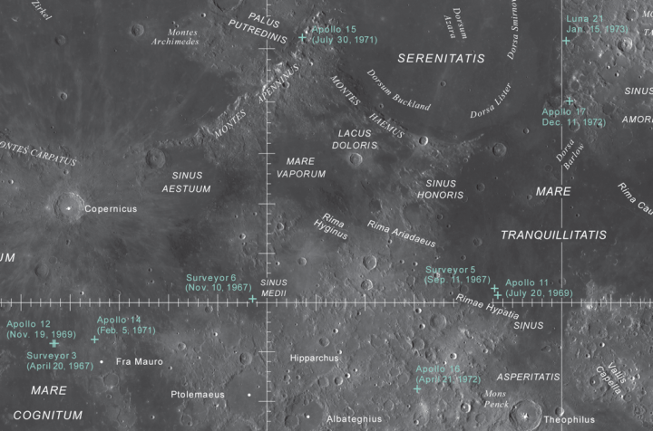
“These maps were designed to help both the public and scientists understand the overall appearance and topography of the moon,” said the USGS in a statement. The maps provide enough detail that amateur astronomers can compare features they see on their telescope with those on the map. It also allows enthusiasts to locate historically important features such as the Apollo landing sites from the comfort of their home.

Both of these maps were made possible by NASA’s Lunar Reconnaissance Orbiter (LRO), a car-sized robotic spacecraft that’s been orbiting the moon and mapping the lunar surface since 2009. The LRO was originally designed to provide detailed lunar information in preparation for future human and robotic missions to the moon. Since its launch, the orbiter has been collecting stunning images showing impact craters, hydrogen deposits, and more.

Editors' Recommendations

Kelly Hodgkins
Kelly's been writing online for ten years, working at Gizmodo, TUAW, and BGR among others. Living near the White Mountains of…
Prepare for liftoff! Here are all the moon missions happening in the next decade
Jeff Bezos Blue Origin Lunar Lander concept shown by Jeff Bezos

This article is part of Apollo: A Lunar Legacy, a multipart series that explores the technological advances behind Apollo 11, their influence on the modern day, and what's next for the moon.

The moon is hot right now -- and this isn't some meteorological warning, either. Earth’s natural lunar satellite is the same approximate temperature it has always been, varying between minus-280 degrees Fahrenheit and 260 degrees Fahrenheit, depending on how much sun it’s getting. In terms of buzzworthy hotness, however, the moon is currently enjoying press like it hasn’t seen since the early 1970s.

Read more
The moon is shrinking as it loses heat, new images reveal
moon shrinkng lro images pia23236 hires 1

New surface features of the Moon have been discovered in a region called Mare Frigoris, outlined here in teal. NASA

New research suggests the Moon may actually be shrinking. NASA scientists have used data from their Lunar Reconnaissance Orbiter Camera (LROC) to look at "wrinkles" in the surface of the Moon which are formed as it loses heat and shrinks in size.

Read more
See the impact site where the Beresheet spacecraft crashed into the moon
beresheet impact site content beresheetimpact after box 1

Left: Beresheet crash site. Right: A comparison of images taken before and after the crash, enhanced to show the subtle changes in the brightness of the surface. NASA/GSFC/Arizona State University

SpaceIL's Beresheet spacecraft might not have made the final hurdle to land on the moon, but it could still make a contribution to scientific knowledge. An image of the site of the crash has been captured by a NASA's Lunar Reconnaissance Orbiter (LRO) and is being analyzed for information about the lunar soil.

Read more