When it comes to driving down the cost of wind energy, one simple way of avoiding unnecessary expenditure is to regularly check the blades of wind turbines for damage. By spotting signs of damage early, blades can be kept in service for longer before needing replacement. Unfortunately, that’s a task that’s easier said than done using traditional inspection methods, such as ground-based surveying. Fortunately, researchers at Sandia National Laboratories have another solution — and it involves a combination of blade-crawling robots and flying inspection drones.
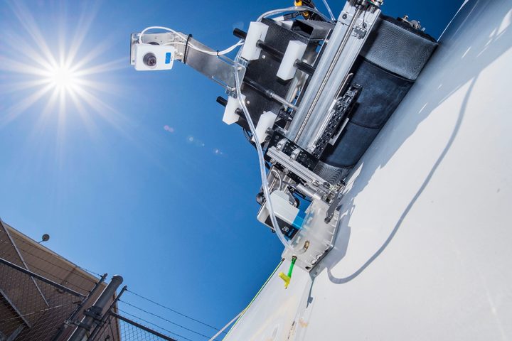
The crawling inspection robots maneuver from side-to-side up and down turbine blades. While doing this, they use on-board cameras to capture high-fidelity images of the blades, in addition to performing special ultrasonic imaging. This provides unique signatures for each blade which can be analyzed to indicate damage. In total, it provides detailed information about both the surface and interior damage of wind blades.
“This technology potentially allows for advanced non-destructive inspection (NDI) techniques to be economically deployed at both land-based and offshore wind plants to scan for damage in blades,” Josh Paquette, wind energy lead on the project, told Digital Trends. “In this case, we have used water-coupled, phased array ultrasonic technology as it has shown to be particularly promising for wind blade inspections. The crawler can be deployed from the turbine nacelle, positioned in the area of interest, and perform a controlled or possibly automated scan. The results of this scan can then be analyzed by a composite materials expert to determine the extent of any damage that may exist.”
A second approach involves using drones equipped with infrared cameras. These UAVs employ the heat from sunlight to detect hidden wind blade damage as deep as half an inch inside a blade.
“The method uses a technique called thermography and scales it down to fit on small commercial drones,” Sandia mechanical engineer Ray Ely told us. “Basically, if you position a blade in the sunlight, the surface will heat up. You can [then] pitch the blade into the shade, and the heat will diffuse into the blade and equalize. However, flaws can disrupt this heat flow and leave the blade surface hotter than expected. A computer on the drone can record information about the size and location of each flaw.”
At present, both of these inspection techniques are proofs-of-concept. The next step will involve deploying them in the field to showcase their effectiveness.