
See how Google Maps is using color to add even more detail

Google Maps is getting even better with the greater use of color to depict additional geographical details in natural features.

Google Maps product manager Sujoy Banerjee said the visual improvement will bring “even more detail and granularity to the map, making it easier to understand what an area looks like whether you’re exploring virtually or planning a visit.”

Banerjee explained that the enhanced level of detail has been made possible by applying a new color-mapping algorithmic technique to its current data to create “an even more comprehensive, vibrant map of an area at global scale.”

It means that from this week, when looking at a location on Google Maps, you’ll get a clearer understanding of its natural features, “so you can easily distinguish tan, arid beaches, and deserts from blue lakes, rivers, oceans, and ravines,” Banerjee said, adding, “You can know at a glance how lush and green a place is with vegetation, and even see if there are snow caps on the peaks of mountaintops.”

Google used computer vision to locate natural features in its huge database of satellite imagery before applying the new coloring. It means that a densely covered forest, for example, will appear as dark green on the map, while an area of patchy shrubs will show up as a lighter shade of green.

To offer a better idea of how much more detail you’ll see on Google Maps, Banerjee posted several before/after images of various places, including Iceland (below), a country famous for its stunning natural landscapes.

Google Maps

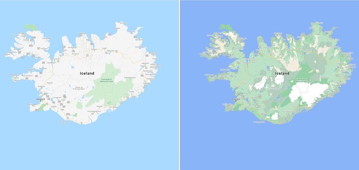
“Iceland’s rich landscape is now much easier to visualize,” the product manager said. “You can see the varying densities of greenery throughout the country and more easily spot Vatnajökull, the largest ice cap in Iceland, which is now depicted in white.”

While these improvements are geared toward natural landscapes, Google is also planning to add highly detailed information for urban areas, too. It means you’ll soon be able to see the shape and width of a road to scale, as well as the precise location of sidewalks, crosswalks, and pedestrian islands — important for those with accessibility needs.

These more detailed city maps will land in the coming months for New York, San Francisco, and London, with more cities added over time.

For more information on how to get the most out of Google Maps, check out Digital Trends’ handy guide.

Editors' Recommendations

Trevor Mogg
Contributing Editor
Not so many moons ago, Trevor moved from one tea-loving island nation that drives on the left (Britain) to another (Japan)…
Google Maps is adding new shopping tools for the holiday season
Person using Google Maps on a smartphone.

Google has announced several new features in Google Maps to keep you sane this holiday season by helping you avoid crowds, find your way around the malls, and even get your holiday dinner shopping done.

First off, Google is expanding its crowdedness data features for public transit and specific stores into a broader tool that it's calling "Area Busyness." This will show you how many folks are gathering in a specific neighborhood, rather than an individual store. As Google explains, you can use this information however you like, whether you want to steer clear of the crowds or seek out the hottest spots in town.

Read more
Sustainable with Google 2021: Nest Renew, traffic light efficiency, and more
Photo of a woman adjusting a Nest Thermostat.

During its Sustainable with Google event on Tuesday, the company announced a range of improvements across its product portfolio that are aimed at helping users make more sustainable decisions. Updates and projects aim to lower carbon emissions by steering people toward more environmentally friendly travel choices, greener products, and more accurate information around climate change.

Besides consumer products, Google took the opportunity at the event to toot its own horn about a previous commitment to having net-zero data centers by 2030. The company says it is leveraging the "cleanest cloud in the industry" for partners like Whirlpool, Etsy, HSBC, Unilever, and Salesforce. More news on that front is expected next week at its annual cloud conference. Here's everything announced at Sustainable with Google 2021.
Nest offers carbon offsets

Read more
How to use the Apple Maps globe view in MacOS Monterey
A Safari window and Apple Maps showing the globe view, both running on MacOS Monterey

In MacOS Monterey, Apple has updated its Apple Maps app to include a new globe view. This shows Earth floating in space, allowing you to quickly spin the planet and zoom in on any location of your choosing.

Using it is straightforward, but it can feel a little hidden since there is no obvious button to click that will activate it. Not to worry, as our guide will show you how to use it, including a few useful features that make it even more useful.

Read more