
Google has published an early look at its COVID-19 Community Mobility Reports, a set of reports for use by health officials showing the effect of the pandemic coronavirus, officially called COVID-19, on people’s mobility. Google has used anonymized location data to track the degree to which people are complying with social distancing advice and staying home rather than attending public places like restaurants, parks, and transit stations. The reports also indicate how many people are still required to travel to work, as opposed to working from home.
“In Google Maps, we use aggregated, anonymized data showing how busy certain types of places are — helping identify when a local business tends to be the most crowded,” Jen Fitzpatrick, SVP of Geo and Karen DeSalvo, Chief Health Officer at Google Health, wrote in a blog post. “We have heard from public health officials that this same type of aggregated, anonymized data could be helpful as they make critical decisions to combat COVID-19.”
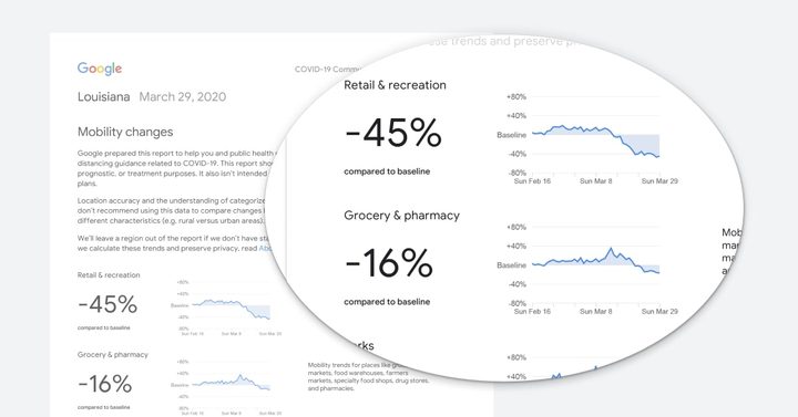
The data is split up by country and region and is shown in a graph format, showing a percentage change in the average time spent in different types of locations. The charts compare the change in time spent in these locations from February 16 to March 29 this year, compared to the baseline values for the same days of the week compared to an earlier 5-week period from January 3 to February 6 this year.
The initial release of the reports covered 131 countries and regions. The data for many countries is available both nationally and regionally, and the U.S. data is available by state. Google says it may provide more information at the regional level in the future, and that it is working to create reports of data from more countries as well.
Google’s use of location data has been criticized in the past for its privacy implications. In this case, Google has emphasized that the data used in the reports is anonymized and that users can opt-out of it by turning off location history: “The Community Mobility Reports were developed to be helpful while adhering to our stringent privacy protocols and protecting people’s privacy,” the company said in its blog post. “No personally identifiable information, such as an individual’s location, contacts or movement, will be made available at any point.
“Insights in these reports are created with aggregated, anonymized sets of data from users who have turned on the Location History setting, which is off by default. People who have Location History turned on can choose to turn it off at any time from their Google Account and can always delete Location History data directly from their Timeline.”


