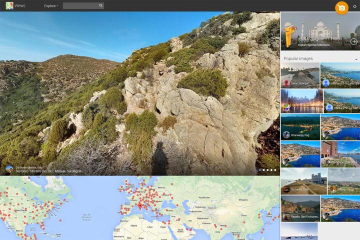
Google’s betting on the latter with its latest new feature for Google Views, which lets users pin photos from their Google+ account to Maps, visually documenting what Street View cannot. Pop open a map of the world and it’s peppered with red pins representing all the publicly shared photos Google users have taken, from mountain views to shuttered storefronts.
If that functionality sounds familiar, it’s because Google Views already allows users to document their travels with Street View-style panoramas, known as Photo Spheres. But you need an Android phone, or Google’s Photo Sphere app for iOS, to carefully stitch those 360-degree views together. The kind of traditional photos most people are actually shooting have been locked out until now.
Related: Now you can take 360-degree photos with Google’s Photo Sphere app on iOS
“What Views is letting us do is let people supply images of the places they go, knowing that’s also probably the places that other people go,” product manager Evan Rapoport told Digital Trends in a Monday interview at company headquarters. “It’s the first photography community that connects photographers to travelers.”
Welcoming photos makes Google Views perilously similar to another Google-owned service, Panoramio. But Rapoport, who also handles that service, insists it will remain alive and thriving. The difference, he contends, will be in the type of photos each service hosts. Panoramio will continue to host scenic vistas and postcard shots of icons like the Eiffel Tower or Taj Mahal, while Views will cater to all types of photography, including snapshots.
That’s not to say photographersare unwelcome. In fact, Google’s team of testers included Colby Brown, a noted professional photographer whose landscape photography literally spans the globe. In contrast, his work appears on Views alongside the likes of Arroz Marisco – a pseudonym for an anonymous amateur photographer who goes out of his way to document places people care about.
Users can add photos by logging into Google, going to Views and clicking the orange photo button in the upper right. Any public photo uploaded to Google+ is a game, and you can manually drop a pin to indicate where it was taken if the location wasn’t automatically recorded with the photo as a geotag.
Editors' Recommendations
- A new Google Pixel Tablet is coming, but it’s not what you think
- Google just announced 8 big Android updates. Here’s what’s new
- Google is bringing Chrome browser to cars, even more EV features to Maps
- The Google Pixel 8 just got its first update. Here’s what’s new
- Google injects AI into Maps in major update