
Remains of shallow, briny pools provide further evidence of liquid water on Mars

A Guide to Gale Crater

As the Curiosity rover explores Mars’ Gale Crater, the data it collects tells us more about the history of the planet and in particular about whether liquid water once existed there. Using data collected by Curiosity, a new study has examined the geology of the crater to learn more about the briny ponds which may once have dotted the planet’s surface.

Recommended Videos

“We went to Gale Crater because it preserves this unique record of a changing Mars,” William Rapin, Caltech researcher and lead author of the study, explained in a statement. “Understanding when and how the planet’s climate started evolving is a piece of another puzzle: When and how long was Mars capable of supporting microbial life at the surface?”

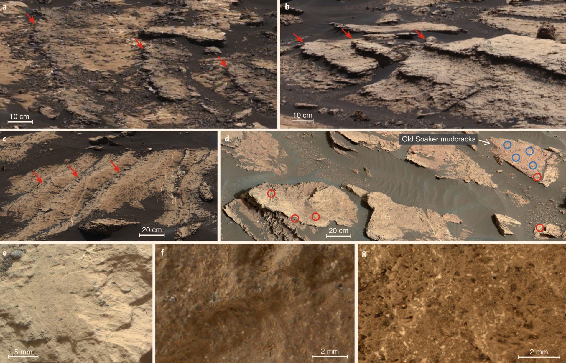
By looking at the salts present in rocks in an area of the crater called Sutton Island, the scientists could build up a picture of the environment through time. They already knew that the area went through drier periods, as the mud in a region called Old Soaker was cracked. The cracks form as the mud dries out.

The new evidence shows there were wet periods too though. The presence of minerals salts mixed with sediment suggests that shallow ponds once formed there, before drying to leave the salts behind. The ponds would have been briny due to the concentrated salts.

Different sulfate elements found in Mars’ Gale Crater: (a) magnesium sulfate-enriched lithology; (b) calcium sulfate enrichments; (c) euhedral white crystals and heterogeneous calcium sulfate and magnesium sulfate enrichments; (d) areas with calcium sulfate enrichments (red) and without (blue); (e, f) close-up images of a mudstone and a sandstone enriched in calcium sulfate; (g) close-up image of bedrock. Rapin et al, doi: 10.1038/s41561-019-0458-8.

To understand more about the formation of these briny lakes, scientists turned to an environment closer to home: “Given that Earth and Mars were similar in their early days, Sutton Island might have resembled saline lakes on South America’s Altiplano,” Dr. Rapin said.

“Streams and rivers flowing from mountain ranges into this arid, high-altitude plateau lead to closed basins similar to Mars’ ancient Gale Crater… During drier periods, the Altiplano lakes become shallower, and some can dry out completely. The fact that they’re vegetation-free even makes them look a little like Mars.”

The research is published in the journal Nature Geoscience.

Georgina Torbet
Georgina has been the space writer at Digital Trends space writer for six years, covering human space exploration, planetary…
See a postcard from Mars taken by the Curiosity rover
NASA’s Curiosity Mars rover used its black-and-white navigation cameras to capture panoramas of “Marker Band Valley” at two times of day on April 8. Color was added to a combination of both panoramas for an artistic interpretation of the scene.

Today, you can enjoy a stunning new view of Mars, thanks to a postcard from the Gale Crater taken by the Curiosity rover. The image combines two different views of the same area and is colorized to show off the undulating martian landscape in a region called the Marker Band Valley.

The image, shared by NASA's Jet Propulsion Laboratory (JPL), shows the back of the rover and views of the tire tracks it has left across the martian surface as it has driven. The view on the left side of the image was taken in the morning of April 8, at 9:20 a.m. local Mars time, while the image on the right side was taken on the same day but in the evening, at 3:40 p.m. local Mars time. The two images have been blended together to show how the landscape looks different throughout the day.

Read more
Perseverance rover finds evidence of an ancient river on Mars
NASA’s Perseverance Mars rover captured this mosaic of a hill nicknamed “Pinestand.” Scientists think the tall sedimentary layers stacked on top of one another here could have been formed by a deep, fast-moving river.

The Perseverance rover has been exploring Mars's Jezero Crater as part of its mission to search for evidence of ancient life on Mars. The history of water is key in the search for life, and it is currently thought that Mars lost its water around 4 million years ago. Now, the rover has identified evidence of what was once one of the deepest and fast-flowing rivers yet discovered on the planet.

The rover captured a series of hundreds of images using its Mastcam-Z instrument, which were put together into this mosaic showing a hill structure called Pinestand. In the image, you can see the many layers left behind by the flowing river, which were formed by deposits of sediment.

Read more
Mars Curiosity rover finds evidence of water where it was expected to be dry
Curiosity Rover

The key to understanding whether Mars was ever habitable is water. For life as we know it to thrive, liquid water needs to be present -- and we know that even though it is now dry, there was once liquid water on the surface of Mars. However, the history of water on Mars is complex, and scientists are still debating exactly how long water was present there and when the planet dried up.

And it's about to get more complex. Recently, the Curiosity rover has made an intriguing discovery suggesting that water was once present in an area that scientists had thought would be dry.

Read more