
How Europe’s ExoMars rover plans to get to Mars without Russia

Space missions get scuppered for all kinds of reasons, from engineering problems to budget issues. But the ExoMars mission, Europe and Russia’s joint plan to send a rover to Mars, faced a complicated political and ethical issue when Russia invaded Ukraine last year. The European Space Agency (ESA) had been working with the Russian space agency Roscomos on the mission but this partnership was soon suspended over what ESA called the “human casualties and tragic consequences of the aggression towards Ukraine.”

Without Roscosmos, the Rosalind Franklin rover was left without a launcher and it was not clear whether the rover would be able to launch at all. But loath to give up on the project, ESA decided it would build its own lander and get the rover to Mars hopefully by 2030. This week, ESA shared more information about the plans for the mission and how it is continuing with testing for the rover.

ESA’s Rosalind Franklin twin rover is back on its wheels and drilled down 1.7 metres into a martian-like ground in Italy – about 25 times deeper than any other rover has ever attempted on Mars. The test rover, known as Amalia, also collected samples for analysis under the watchful eye of European science teams.
ESA’s Rosalind Franklin twin rover is back on its wheels and drilled down 1.7 meters into a martian-like ground in Italy – about 25 times deeper than any other rover has ever attempted on Mars. The test rover, known as Amalia, also collected samples for analysis under the watchful eye of European science teams. ESA – S. Corvaja

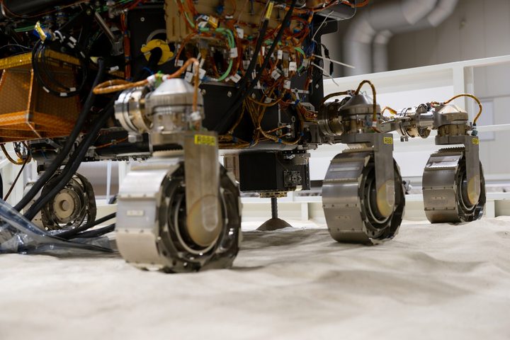
While ESA estimates it will take at least three to four years to build a new lander, the rover itself has been close to ready for a long time. It was originally scheduled for launch in 2020 but was delayed due to the coronavirus pandemic, then for launch in 2022 which was delayed due to the invasion of Ukraine. Now engineers are continuing to test the rover along with its twin, Amalia, recently putting it through a drilling test in a simulated martian environment.

The rover will dig nearly 6 feet down into the Martian surface, which is 25 times deeper than previous Mars missions have gone, to look for subsurface features like water ice. The recent tests used layers of soft silica, sand, and volcanic soil to simulate the martian soil and test whether the drill could be used to collect samples.

The twin rover was able to take a sample, use its imager to take close-up photos of the sample, and crush the sample into powder for scientific analysis. This test shows that the rover itself is looking in good shape, but the whole process of designing and building a lander for the rover still needs to be addressed.

In a video, ESA staff talk about the decision to suspend the mission and how they are adjusting to the new plan. “The war in Ukraine has had a massive impact on our work,” Pietro Baglioni, ExoMars Rover Manager, said in the video. “We were ready to go with the launch campaign for ExoMars, and we had all of a sudden to stop and to reconsider our plans.”

“For the team, it has been very difficult to digest this decision because they’ve been working very hard in the last years,” Baglioni went on. “It was indeed difficult also from a human perspective. But of course, they understand the political implications so they managed to reset.”

Georgina Torbet
Georgina is the Digital Trends space writer, covering human space exploration, planetary science, and cosmology. She…
Curiosity rover battles up a 23-degree slope in its exploration of Mars
Curiosity Rover

The Curiosity rover is slowly making its way up Mount Sharp, a 3-mile-tall mountain on Mars. Mountains are useful to study as their steep slopes can reveal layers of material laid down over time, like a geological time capsule. But just like heaving up a mountain is a challenge for humans, it can be tricky for rovers too. Curiosity recently took on a particularly steep and slippery slope, marking its most challenging climb to date.

How difficult terrain is for a rover to pass depends on a number of factors, including how steep it is, how slippery the sand is, and what obstacles such as boulders or sharp rocks are present. This ascent, which the rover tackled through May and June, had all of the above including a 23-degree incline. “If you’ve ever tried running up a sand dune on a beach – and that’s essentially what we were doing – you know it’s hard, but there were boulders in there as well,” said Amy Hale, a Curiosity rover driver at NASA’s Jet Propulsion Laboratory (JPL), in a statement.

Read more
Perseverance rover finds organic molecules in Mars’ Jezero Crater
mars 2020 perseverance rover

One of the biggest aims of Mars research right now is trying to figure out if life ever existed on Mars. Given how dry and inhospitable Mars is today, scientists are pretty certain that there's nothing living there currently. But millions of years ago, Mars could have looked a lot more like Earth, with plentiful surface water in rivers and lakes. Now, research focuses on using the instruments on rovers like the Perseverance and Curiosity rovers to try and look for evidence of ancient life on the planet.

Recently, researchers used data from Perseverance's SHERLOC instrument, a camera and spectrometer used to detect minerals and organic molecules, to confirm the discovery of a variety of organic molecules in Mars' Jezero Crater. Similar findings have been made by the Curiosity Rover in the Gale Crater, but these are some of the first indications of the finding in this other location.

Read more
See a postcard from Mars taken by the Curiosity rover
NASA’s Curiosity Mars rover used its black-and-white navigation cameras to capture panoramas of “Marker Band Valley” at two times of day on April 8. Color was added to a combination of both panoramas for an artistic interpretation of the scene.

Today, you can enjoy a stunning new view of Mars, thanks to a postcard from the Gale Crater taken by the Curiosity rover. The image combines two different views of the same area and is colorized to show off the undulating martian landscape in a region called the Marker Band Valley.

The image, shared by NASA's Jet Propulsion Laboratory (JPL), shows the back of the rover and views of the tire tracks it has left across the martian surface as it has driven. The view on the left side of the image was taken in the morning of April 8, at 9:20 a.m. local Mars time, while the image on the right side was taken on the same day but in the evening, at 3:40 p.m. local Mars time. The two images have been blended together to show how the landscape looks different throughout the day.

Read more