
Delightful interactive map of Mars lets you take a wander with Perseverance rover

If you’ve ever wanted to take a trip to Mars and go on a hike with the Perseverance rover, now is your chance. Researchers have created an interactive map of Mars’s Jezero Crater, letting you virtually wander around the planet’s surface and follow the rover’s path.

The interactive map shows data like topography, contour lines, and the rover’s path and current position within the crater. There are also panoramic views marked so you can zoom in and appreciate 360-degree views of the vistas of Mars.

Related Videos
Virtual view from top of the western delta into the crater.
Virtual view from the top of the western delta into the crater. HiRISE/CTX/HRSC

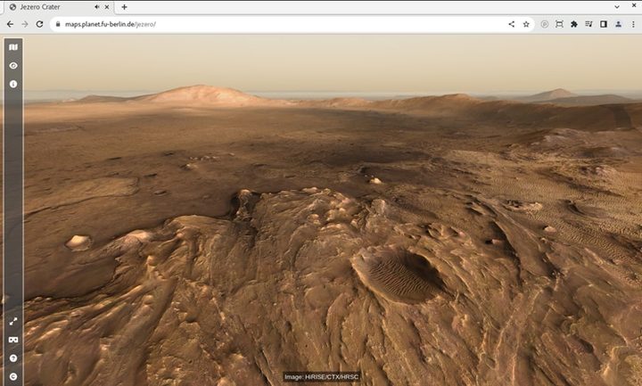
The map was presented at the Europlanet Science Congress 2022 by Sebastian Walter of the Freie Universität Berlin.

“The map is the perfect tool for planning a future visit to Mars, with an interactive interface where you can choose from different available base datasets,” Walter said in a statement. “Some of the slopes are pretty steep, so watch out for those if you want to avoid too much oxygen consumption! To get a real feeling of what to expect on your future Mars trip, you can click on one of the waypoint marker symbols to enter either a fullscreen 3D view or, if you have a Virtual Reality setup, to enter a fully immersive environment. You can even listen to the sounds of the rover if you stand close by.”

The data for the map is a combination of data recorded by Perseverance, like the images from its Mastcam-Z camera and the sounds from its SuperCam instrument, and data taken from orbiters which forms the base layer of the map. This orbital data came from the European Space Agency’s Mars Express and NASA’s Mars Reconnaissance Orbiter, both of which are used to capture high-resolution images of the surface.

The map was originally designed for professional scientists, according to Walter, but as they added more data the research team realized it would be fun for the public to access as well.

“Initially we created the Jezero map as an outreach application to complement the HRSC Mapserver tool, which supports professional scientists to explore the Martian surface,” said Walter. “But as the rover returns more and more high-resolution image data and even audio recordings, it turns out to be the perfect tool for immersive visualization of that data in a scientific context by itself.”

Editors' Recommendations

It’s been 2 years since the Perseverance rover landed on Mars
This image of the floor of Jezero Crater was taken by one of the Navcam imagers aboard NASA’s Perseverance Mars rover on Feb. 5, the 698th Martian day, or sol, of the mission.

Today marks the second anniversary since the rover Perseverance landed on the surface of Mars on February 18, 2021. The nail-biting descent and landing process was followed around the world, and was particularly memorable because of the spectacular video taken from both the rover and its descent stage showing the touchdown onto the red planet.

In the two Earth years since Perseverance arrived on Mars, it has collected samples of rock and built a sample depot, deployed the Mars helicopter Ingenuity, created oxygen from the carbon dioxide atmosphere, recorded the sounds of Mars for the first time, trundled along the floor of the Jezero crater and made its way toward the site of an ancient river delta, and taken some stunning images.

Read more
Perseverance Mars rover shares detailed panorama of sample depot
The site of Perseverance's sample depot.

NASA’s Perseverance Mars rover has been busy creating what the space agency recently said was “humanity’s first sample depot on another planet.”

The depot, which is essentially a flat patch of land, contains 10 titanium tubes holding samples of martian rock and dust collected by NASA’s rover in the two years since it landed on the red planet.

Read more
Ingenuity helicopter helps researchers learn about dust on Mars
The Ingenuity helicopter is pictured on the surface of Mars.

One of the big challenges of Mars exploration is something very small: dust. Fine dust covers much of the martian surface, and high winds and low gravity mean the dust is easily whipped up off the surface, covering solar panels and gumming up components. The Ingenuity helicopter has had its own problems with dust on its solar panels, limiting the amount of power it could draw from the sun.

Now, researchers have used data from Ingenuity to understand more about how dust moves in the martian air, learning about the dynamics of dust, which could help future missions deal with this ongoing problem.

Read more