
See and hear the first science results from Perseverance’s SuperCam instrument

This image shows a close-up view of the rock target named “Máaz” from the SuperCam instrument on NASA’s Perseverance Mars rover. It was taken by SuperCam’s Remote Micro-Imager (RMI). “Máaz” means Mars in the Navajo language.
This image shows a close-up view of the rock target named “Máaz” from the SuperCam instrument on NASA’s Perseverance Mars rover. It was taken by SuperCam’s Remote Micro-Imager (RMI). “Máaz” means Mars in the Navajo language. NASA/JPL-Caltech/LANL/CNES/CNRS

With NASA’s newest rover Perseverance safely landing on Mars last month, it has now begun its science operations. It recently took first readings using one of its instruments, SuperCam, which is located on the top of the rover’s mast. SuperCam contains a high-resolution camera, a microphone, and a high-powered laser for performing spectroscopy on rock samples to see what they are composed of.

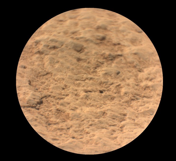
SuperCam was used to snap a close-up image of a rock, shown above. The rock target is named “Máaz,” from the Navajo language, which means “Mars.” The data was sent from the rover to a group of French laboratories at the Centre National d’Etudes Spatiales (CNES)

“It is amazing to see SuperCam working so well on Mars,” said Roger Wiens, the principal investigator for Perseverance’s SuperCam instrument from Los Alamos National Laboratory in New Mexico, in a statement. “When we first dreamed up this instrument eight years ago, we worried that we were being way too ambitious. Now it is up there working like a charm.”

The SuperCam instrument also includes a microphone, which can be used to measure the sound of the laser entering a rock sample. This tells researchers information about factors like how deep the laser is penetrating and the hardness of the rock.

It also means that the microphone can be used to record the sounds of Mars, including the sound of the wind which was recorded just after the rover landed and while the mast was still folder down. NASA has now shared three audio clips recorded by SuperCam. “The sounds acquired are remarkable quality,” said Naomi Murdoch, a research scientist and lecturer at the ISAE-SUPAERO aerospace engineering school in Toulouse. “It’s incredible to think that we’re going to do science with the first sounds ever recorded on the surface of Mars!”

“I want to extend my sincere thanks and congratulations to our international partners at CNES and the SuperCam team for being a part of this momentous journey with us,” said Thomas Zurbuchen, associate administrator for science at NASA Headquarters. “SuperCam truly gives our rover eyes to see promising rock samples and ears to hear what it sounds like when the lasers strike them. This information will be essential when determining which samples to cache and ultimately return to Earth through our groundbreaking Mars Sample Return Campaign, which will be one of the most ambitious feats ever undertaken by humanity.”

Editors' Recommendations

Georgina Torbet
Georgina is the Digital Trends space writer, covering human space exploration, planetary science, and cosmology. She…
See a 3D view of a martian crater captured by the Perseverance rover
A snippet of the mosaic of Belva Crater taken by the Perseverance rover.

The Jezero crater on Mars, where NASA's Perseverance is currently exploring, is vast at nearly 30 miles across and was likely created by a huge asteroid impact. But there wasn't just one asteroid impact -- it's thought that several asteroids hit the area over millions of years, creating a succession of craters that overlap and fit within each other.

A snippet of the mosaic of Belva Crater taken by the Perseverance rover. NASA/JPL-Caltech/ASU/MSSS

Read more
Perseverance rover finds evidence of an ancient river on Mars
NASA’s Perseverance Mars rover captured this mosaic of a hill nicknamed “Pinestand.” Scientists think the tall sedimentary layers stacked on top of one another here could have been formed by a deep, fast-moving river.

The Perseverance rover has been exploring Mars's Jezero Crater as part of its mission to search for evidence of ancient life on Mars. The history of water is key in the search for life, and it is currently thought that Mars lost its water around 4 million years ago. Now, the rover has identified evidence of what was once one of the deepest and fast-flowing rivers yet discovered on the planet.

The rover captured a series of hundreds of images using its Mastcam-Z instrument, which were put together into this mosaic showing a hill structure called Pinestand. In the image, you can see the many layers left behind by the flowing river, which were formed by deposits of sediment.

Read more
See the first image of Earth from a new weather-monitoring satellite
First image of the full Earth disc from the Meteosat Third Generation Imager. The first image from Meteosat Third Generation – Imager 1 (MTG-I1) reveals a level of detail about the weather over Europe and Africa not previously possible from 36 000 km above Earth. The higher-resolution images provided by the instruments on board give weather forecasters more information about the clouds cloaking much of Europe and visible in the equatorial region of Africa and the Atlantic Ocean. Sand and sediment in the waters off Italy are also visible, as well as dust or smog being carried from south Asia. This degree of detail is not possible from the instruments on the Meteosat Second Generation satellites. The image was captured at 11:50 UTC on 18 March 2023 by the Flexible Combined Imager on MTG-I1.

A recently launched weather satellite has sent back its first image of Earth, showing our planet in gorgeous detail. The European Meteosat Third Generation Imager-1 was launched in December of last year with the aim of monitoring weather conditions across Europe and Africa, and it took this image from its location 22,000 miles above the Earth's surface.

The image was taken using the high-resolution Flexible Combined Imager instrument in March 2023, showing the areas of cloud and clear skies that can be seen over the Atlantic Ocean, as well as the European and African land masses.

Read more