
In the ever-advancing field of global science, you might think that discovering animal poop in satellite imagery would be of little consequence.
But for a research team studying Antarctica, making such a find led to what it described as “an exciting discovery.”
Perhaps we’d better explain.
After poring over images from the European Commission’s Copernicus Sentinel-2 satellite mission and also the Maxar WorldView-3 satellite, scientists were recently able to confirm the existence of a new emperor penguin colony comprising around 500 birds.
The scientists were able to identify the colony from the birds’ guano stains, which are brown in color and therefore relatively easy to spot against the ice and rock, the British Antarctic Survey (BAS) explained in a report.
The emperor penguin is the tallest and heaviest of all living penguin types, and last year was declared a threatened species by the U.S. government due to the effects of the changing climate.
The image below is from the Maxar satellite and shows the location of the newly discovered colony at Verleger Point in West Antarctica.
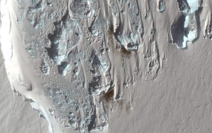
This latest discovery means that scientists now have data on 66 emperor penguin colonies along the Antarctica coastline, with half of these discovered via satellite imagery.
“This is an exciting discovery,” said Dr. Peter Fretwell, who studies wildlife from space at BAS. “The new satellite images of Antarctica’s coastline have enabled us to find many new colonies. And whilst this is good news, like many of the recently discovered sites, this colony is small and in a region badly affected by recent sea ice loss.”
The BAS said that according to current projections for climate change, the penguins’ natural sea ice habitat will be hard hit, leading to 80% of these colonies becoming quasi-extinct by the end of the century.
BAS also noted how emperor colonies in the area are difficult to study because they often exist in remote and inaccessible locations. The conditions at these sites often see temperatures dropping to as low as −76 degrees fahrenheit (−60 degrees Celsius). It’s these factors that prompted BAS to start using satellite imagery 15 years ago, with scientists keeping their eyes peeled for guano stains on the ice.
Several years ago, conservationists also started using Maxar’s powerful satellite to gather data on another endangered species.


