
New Street View images of Japan tsunami disaster show full extent of damage

Back in July, Google announced its intention to digitally archive the devastation caused by March’s tsunami in north-eastern Japan, which claimed the lives of nearly 20,000 people. “This [Street View] imagery will help people in Japan and across the world remember and observe the tragedy of March 11, 2011,” the Mountain View company said.

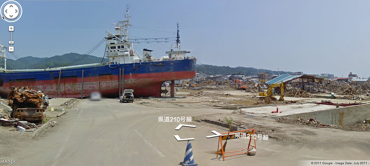
In a post on the official Google blog on Tuesday, it said that after driving more than 27,000 miles (44,000 km) through the affected areas, the images could now be viewed.

Related Videos

“A virtual tour via Street View profoundly illustrates how much these natural disasters have transformed these communities,” Street View’s senior product manager Kei Kawai wrote in the post.

“If you start inland and venture out toward the coast, you’ll see the idyllic countryside change dramatically, becoming cluttered with mountains of rubble and debris as you get closer to the ocean. In the cities, buildings that once stood proud are now empty spaces.”

The special Memories for the Future website also shows before/after comparisons – where old Street View images are available – accessible by clicking the green ‘before’ button at the top right of the webpage. In addition, all images are now date stamped in the bottom right corner.

“When looking at images of the magnificent cities side-by-side with images of the ruins left in their place, this additional context demonstrates how truly life-changing this tragedy has been for those who live there and witnessed the destruction of their homes, neighborhoods and even entire districts,” Kawai wrote.

He added that Google hoped the archiving of images from the disaster area would help researchers and scientists studying the effects of natural disasters, and said that the street-level imagery “puts the plight of these communities into perspective and ensures that the memories of the disaster remain relevant and tangible for future generations.”

The massive quake and ensuing tsunami struck Japan on March 11, laying waste to many communities along the country’s north-eastern coast and badly damaging the Fukushima nuclear power plant. 

Editors' Recommendations

Topics
A.I. predicts how you vote by looking at where you live on Google Street View
street view ai politics 22 artificialin

Google Maps’ Street View feature is a great way to explore the world around you, but could it be revealing more about your neighborhood than you think? That's quite possible, suggests new research coming out of Stanford University. Computer science researchers there have been demonstrated how deep learning artificial intelligence can scour the images on Google Street View and draw conclusions about issues like the political leaning of a particular area — just by looking at the cars parked out on the street.

“We wanted to show that useful insight can be gained from images, the same way people do this for social networks or other textual-based data,” Timnit Gebru, one of the lead researchers on the paper, told Digital Trends. “Some of the car-politics or car-race associations were intuitive, but still surprising that we could capture from our data.”

Read more
Ditch the 3D stitch — updated algorithm means a clearer Google Street View
google street view optical flow stitch software googlestitch

Nothing quite disrupts the "being there" experience of a 360 photo like a bad stitch line. But Google Street View panoramas will soon have fewer disruptions thanks to new research by Google. On Thursday, November 9, Google Research shared a new algorithm to create more seamless stitches.

While Google says proper hardware can help minimize stitch lines, factors like parallax, or that effect where straight lines appear to curve together in the distance, can create problems for the software. A slight time difference between each photo can still create oddities where the images meet, which can pop up often since Street View Cameras are often mounted on top of moving cars. To illustrate, Google shared images of the Sydney Opera House with off-kilter architecture and a panorama of the Tower Bridge in London where the bridge doesn’t actually meet up with the other half.

Read more
Wool you look at that: Sheep-powered Google Street View now live
faroe islands

Having a population of 50,000 people, unfortunately, doesn't always make the Faroe Islands a top priority for many companies -- like Google Street View. But after launching Sheep View 360, a cleverly titled project that strapped 360-degree cameras onto the backs of sheep, the residents of the Faroe Islands captured Google's attention. A year later, the Faroe Islands are now available to explore through Google Street View.

There are roughly 70,000 sheep in the Faroe Islands -- what better way to map out the archipelago, whose name means "the islands of sheep?" The campaign was put together by the Faroese Tourist Board, which used the hashtag "#wewantGoogleStreetView" to attract the search giant. The initial video received more than 479,000 views and brought Google arrived with more 360 cameras to mount on cars, hikers, horseback riders, kayakers and even a wheelbarrow.

Read more