
Wildfire: Website lets Fort McMurray residents see the state of their home

wildfire website lets fort mcmurray residents see the state of their home satellite
With the Fort McMurray fire zone in Alberta still not safe to enter, many residents who fled to evacuation centers are wondering what’s become of their home.

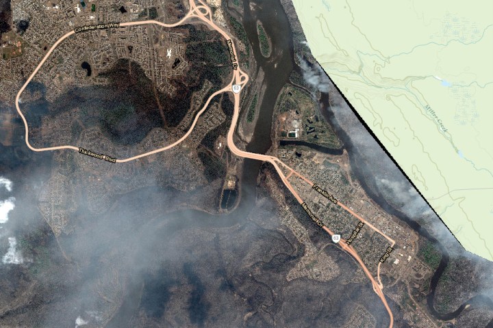
In a move that for evacuees could turn out to be as harrowing as it is helpful, local government officials have launched a website showing recent satellite imagery of the city so worried residents can check on the condition of their property.

More than 80,000 people were forced to evacuate Fort McMurray when a huge wildfire swept through the community earlier this month. Estimates suggest around 20 percent, or roughly 1,600 properties, were destroyed in the disaster, the cause of which is still under investigation.

Addressing the evacuees directly, Municipal Affairs Minister Danielle Larivee said in a release that officials were committed to providing information “as soon as we can,” adding that the imagery would “help us begin to answer the questions you have about the state of your homes and community.”

At first glance, the website’s imagery resembles that of Google Earth, though look more closely and the sight of smoke hanging in the air offers the first clue that all is not well on the ground. Zoom in and you’ll soon see clusters of homes ravaged by the wildfire.

Larivee said the imagery is intended to provide “a high-level satellite overview of the status of the city,” but noted that houses that appear to be intact “should not be considered undamaged.”

In a somewhat chilling note that emphasizes the true scale of the disaster and the impact on those involved, Larivee said, “Viewing these images may be traumatic,” in the next sentence offering the number of a 24/7 mental health help line.

The minister promised higher-resolution imagery “in the days ahead,” suggesting it could show enough detail to assist property owners with insurance claims, recovery-eligibility funding, and other recovery actions. The content can be viewed by hitting the link at the foot of this page.

One Fort McMurray resident who won’t be needing the satellite imagery is James O’Reilly. After fleeing the city, he accessed his home security camera’s live feed, watching in horror as the flames destroyed his property.

Editors' Recommendations

Trevor Mogg
Contributing Editor
Not so many moons ago, Trevor moved from one tea-loving island nation that drives on the left (Britain) to another (Japan)…
Skype now supports 911 calls in the U.S.
iPhone with the Skype mobile app loading screen.

Skype has updated its mobile and desktop apps to allow emergency calling in the U.S. for the first time in its 18-year history. Calls to 911 are also possible via Skype’s web-based service, notes for the recently released Skype 8.80 showed.

Emergency calling from Skype could come in handy if you find yourself in a tricky situation without a phone but have a computer close by, or if phone lines are down but you can get online.

Read more
The Interplanetary File System: How you’ll store files in the future
Cloud storage for downloading an isometric. A digital service or application with data transmission. Network computing technologies. Futuristic Server. Digital space. Data storage. Vector illustration.

When you upload a file or send a tweet, your information is stashed in some corporation-owned mega data center in the middle of nowhere. The endless racks of computers in these facilities hold millions of ledgers, and with a flick of a switch, companies can censor or misuse the data.

But what if instead of handing it to, say Amazon or Google, your data is broken down into pieces and scattered across the globe so that no one except you and your key -- not even the government -- can access it?

Read more
The best hurricane trackers for Android and iOS in 2022
Truck caught in gale force winds.

Hurricane season strikes fear into the hearts of those who live in its direct path, as well as distanced loved ones who worry for their safety. If you've ever sat up all night in a state of panic for a family member caught home alone in the middle of a destructive storm, dependent only on intermittent live TV reports for updates, a hurricane tracker app is a must-have tool. There are plenty of hurricane trackers that can help you prepare for these perilous events, monitor their progress while underway, and assist in recovery. We've gathered the best apps for following storms, predicting storm paths, and delivering on-the-ground advice for shelter and emergency services. Most are free to download and are ad-supported. Premium versions remove ads and add additional features.

You may lose power during a storm, so consider purchasing a portable power source,  just in case. We have a few handy suggestions for some of the best portable generators and power stations available. 

Read more