
Last year saw the most devastating wildfire season on record in California. Over the course of the year, more than 9,000 separate fires burned through 1.3 million acres of land in the state, according to the California Department of Forestry and Fire Protection. Upward of 10,000 buildings were destroyed in the wildfires, which also claimed the lives of 47 people. In the aftermath, a large number of people are understandably looking for a proactive solution to help avert future blazes. Could drones help?
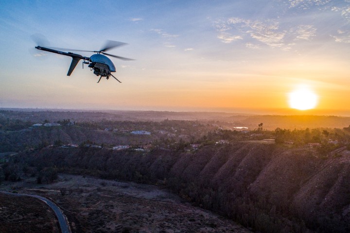
One company, Flight Evolved, is doing its part to help. Having long used drones to create 3D maps for utility companies, Flight Evolved has been called in by some of the Golden State’s largest utilities to find ways of avoiding another destructive season. The innovative startup uses multicopter drones equipped with lidar remote sensing for its work.
“If you’ve been following the automotive industry, you’ll know that lidar is the hot-ticket item right now,” David Ilgenfritz, co-owner and chief operating officer of Flight Evolved, told Digital Trends. “It shoots out laser pulses and measures distances to objects in a way that allows it to make maps in 3D space. We use similar scanners, designed for surveying, to map out utility assets for companies — in this case as part of a fire mitigation program. We’re working with engineering companies and vegetation management companies to provide them with data to assist in the assessment of potential fire threat zones.”
Ilgenfritz said that utility companies have long created maps showing the layout of power lines and electrical equipment, and their proximity to trees and other forms of vegetation — which could result in fire hazards. However, before Lidar-equipped drones came along, this was either achieved using ground surveys or, at best, snapping a few photos from a helicopter.
“Our drones shoot out a million laser pulses, compared to a surveyor who is shooting one image at a time,” Ilgenfritz said. “The efficiency gain is therefore pretty significant.”
Using state-of-the-art RIEGL VUX-1 lidar detectors, the team creates detailed maps of the scenery and then uses forecasting and modeling techniques to predict how wildfires are likely to spread. As a result, they can gather deep data insights which could help prevent fires by, for instance, removing vegetation that would let it spread — or, in the case of a fire, potentially offer other actionable data.
While it’s still relatively early days, the hope is that projects such as this one could help save billions of dollars — and people’s lives, too.
Editors' Recommendations
- Wildfire smoke prompts Google to issue work-from-home advisory
- Here’s how you could protect your RTX 4090 from melting
- Drone delivery from this new location makes perfect sense
- Watch this daredevil ad shot by a drone from way up
- How the space station is helping U.S. fire crews battle wildfires


