
The AllTrails app gets even better, adds more details in new map layer

AllTrails (iOS/Android) has been a popular smartphone app among hikers, trail runners, and mountain bikers for some time now and has even earned a spot on our list of the best hiking apps. With its online community consisting of more than 8 million users, the AllTrails app and website offer crowdsourced info on more than 50,000 trails, including reviews, photos, and first-hand reports on current conditions. But a recent update to the app promises to deliver some nice improvements designed to make it even more valuable to outdoor enthusiasts.

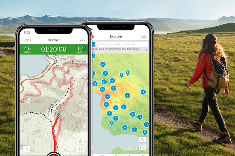
The latest version of the AllTrails app includes a new map layer that the company says was rebuilt from the ground up to provide the best possible trail map its users have ever seen. Among the improvements are better labeling of local, state, and national parks, with the borders of those parks clearly visible on the maps themselves. This new design element was implemented to make it easier for hikers to find new places to explore, both at home and while traveling. Using their phone’s built-in GPS capabilities, users simply open the app and see which parks are nearby their current location.

But that isn’t the only improvement that outdoor athletes will find after updating the app. AllTrails says that its cartographers have completely redesigned the maps that it uses in an effort to improve legibility. These subtle, but important, tweaks reportedly make the maps easier to use, conveying a better sense of the space that the user is currently exploring. If that wasn’t enough, the app now includes more points of interests too, with campsites, restrooms, public parking, drinking water, picnic areas, and other important items now being added to the mix.

These improvements have been automatically added to the AllTrails app, which is free to users. The service also offers a premium tier for those willing to pay for some additional features. AllTrails Pro users gain the ability to download maps for offline use while customizing their routes with waypoints and personal notes. For $2.50 per month (or a $100 lifetime subscription), Pro users can also print maps, receive real-time weather alerts, and removes ads from within the app.

Editors' Recommendations

Kraig Becker
Kraig Becker is a freelance outdoor writer who loves to hike, camp, mountain bike, trail run, paddle, or just about any other…
This mapping app will keep you from getting lost even without a network connection
avenza maps app hiker using mobile device

Modern maps apps on our mobile devices are incredibly useful, helping us to navigate from one place to the next, keeping us informed on shifting traffic patterns, and recommending places to eat, drink, and shop too. But, take away our device's Internet connection and suddenly those same apps aren't quite so handy. Without their ability to download information about our current surroundings they become all but useless. That is not the case with Avenza Maps which was built to function offline, offering high-quality maps even when traveling off the grid.

Available as a free download for iOS, Android, and Windows, Avenza Maps serves as a portal to the Avenza Map Store, which is filled with hundreds of different maps that are available to purchase for a nominal fee. Those maps were created by professional cartographers, surveyors, and organizations like National Geographic and the U.S. Forest Service. Many are even specialized for use in national parks, hiking trails, and other recreational areas around the world.

Read more
With REI’s mobile apps, you’ll never run out of outdoor adventures
Black Canyon Gunnison Colorado

Imagine that the sun is shining, the birds are chirping, and that there is absolutely no reason to be inside. It's time to be adventurous. The problem is, you don't know what to do or where to go. With the suite of REI mobile apps, however, the problem instead will be where not to go.

With REI's recent acquisition of Adventure Projects, those looking to explore can use these apps to find the next best trail to hike, bike, or ski. The apps are composed largely of GPS-based trail guides, but they are sport-specific for easier access.

Read more
Google Maps imagery is about to get even better thanks to a new eye in the sky
worldview 4 satellite digitalglobe

Just when you thought Google Maps couldn't get any better, up pops imagery specialist DigitalGlobe with the first picture from its recently launched WorldView-4 satellite.

Snapped from 617 kilometers (383 miles) above Earth at the end of last month, the pin-sharp picture shows Tokyo's Yoyogi National Gymnasium, a venue that played a part in the 1964 Olympics and which is set to see more action in the 2020 Games.

Read more