
Curiosity snaps a selfie as it explores ‘Mary Anning’ on Mars

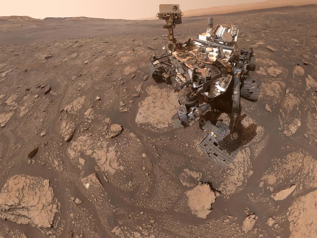
NASA’s Curiosity rover is waiting to be joined on Mars by its sibling Perseverance, set to land on the red planet in February next year. But in the meantime, Curiosity is keeping busy with its own research, and has recently snapped a striking selfie as it explored a region known as “Mary Anning.”

The rover drilled three holes to search for organic molecules in the rocks, and having concluded its experiments, it is now moving on to its next target. But before it departed the area, it took this image of itself by the drill sites.

“Curiosity took the selfie using a camera called the Mars Hand Lens Imager located on the end of its robotic arm,” NASA said in a blog post. “A close-up detail from within the selfie shows the three holes that a rock drill, also found on the end of Curiosity’s arm, added to the surface. The three drill holes are named ‘Mary Anning,’ ‘Mary Anning 3,’ and ‘Groken,’ the last name coming from a site of geological interest in the Scottish countryside.”

NASA's Curiosity Mars rover took this selfie at a location nicknamed "Mary Anning" after a 19th century English paleontologist. Curiosity snagged three samples of drilled rock at this site on its way out of the Glen Torridon region, which scientists believe preserves an ancient habitable environment.
NASA’s Curiosity Mars rover took this selfie at a location nicknamed “Mary Anning” after a 19th century English paleontologist. Curiosity snagged three samples of drilled rock at this site on its way out of the Glen Torridon region, which scientists believe preserves an ancient habitable environment. NASA/JPL-Caltech/MSSS

This location is named after a 19th-century paleontologist who is famous for discovering and classifying Jurassic fossils on the coast of Dorset in the U.K. The Curiosity team chose to name this area in her honor to reflect her often-overlooked contribution to the science of early life forms, as they explain in a blog post: “Mary Anning spent her life scouring the seaside cliffs near Lyme Regis, along the southern coast of England, for fossils. She uncovered innumerable samples, most notably the first full Ichthyosaur and the first Plesiosaur. But as all too often occurs in society, Mary Anning’s gender and societal status led her groundbreaking work and discoveries to be dismissed by the scientific establishment or, worse, appropriated by men.”

The rover is now checking out the “Maybole” outcrop, which is an unusual ledge of particular interest to geologists. The team wants to know whether the outcrop is a different type of rock to the lower terrain surrounding it and whether it might have features in common with the sulfate unit which the rover is heading toward.

Georgina Torbet
Georgina is the Digital Trends space writer, covering human space exploration, planetary science, and cosmology. She…
This team of legged robots could be the future of Mars exploration
A team of legged rovers explores a rugged surface.

If you’d been a fly on the wall at the Rockhal concert hall in Luxembourg in September 2022, you’d have been greeted by a strange sight: no bands or cheering crowds in sight, but rather an area filled with 220 tons of lava and rock, with teams of robots crawling across the dusty floor in search of resources.

It was the second and final round of the European Space Agency (ESA)’s Space Resources Challenge, which invited research groups to bring their prototype robots and test out their abilities to prospect for resources in a simulated moon environment. The idea was to look for bright ideas for the next generation of robotic space explorers that could help locate and map lunar resources, such as water, which are essential for future crewed missions.

Read more
Curiosity rover battles up a 23-degree slope in its exploration of Mars
Curiosity Rover

The Curiosity rover is slowly making its way up Mount Sharp, a 3-mile-tall mountain on Mars. Mountains are useful to study as their steep slopes can reveal layers of material laid down over time, like a geological time capsule. But just like heaving up a mountain is a challenge for humans, it can be tricky for rovers too. Curiosity recently took on a particularly steep and slippery slope, marking its most challenging climb to date.

How difficult terrain is for a rover to pass depends on a number of factors, including how steep it is, how slippery the sand is, and what obstacles such as boulders or sharp rocks are present. This ascent, which the rover tackled through May and June, had all of the above including a 23-degree incline. “If you’ve ever tried running up a sand dune on a beach – and that’s essentially what we were doing – you know it’s hard, but there were boulders in there as well,” said Amy Hale, a Curiosity rover driver at NASA’s Jet Propulsion Laboratory (JPL), in a statement.

Read more
See a postcard from Mars taken by the Curiosity rover
NASA’s Curiosity Mars rover used its black-and-white navigation cameras to capture panoramas of “Marker Band Valley” at two times of day on April 8. Color was added to a combination of both panoramas for an artistic interpretation of the scene.

Today, you can enjoy a stunning new view of Mars, thanks to a postcard from the Gale Crater taken by the Curiosity rover. The image combines two different views of the same area and is colorized to show off the undulating martian landscape in a region called the Marker Band Valley.

The image, shared by NASA's Jet Propulsion Laboratory (JPL), shows the back of the rover and views of the tire tracks it has left across the martian surface as it has driven. The view on the left side of the image was taken in the morning of April 8, at 9:20 a.m. local Mars time, while the image on the right side was taken on the same day but in the evening, at 3:40 p.m. local Mars time. The two images have been blended together to show how the landscape looks different throughout the day.

Read more