
See both of NASA’s explorers, Curiosity and InSight, on the surface of Mars

The HiRISE camera on NASA’s Mars Reconnaissance Orbiter got its best view yet of the InSight lander on September 23, 2019. NASA/JPL-Caltech/University of Arizona

NASA’s Mars Reconnaissance Orbiter (MRO) is currently in orbit around the red planet and is snapping photos of its surface using an instrument called the High-Resolution Imaging Science Experiment (HiRISE). Recently, HiRISE imaged not just one but both of NASA’s missions which are on the planet right now.

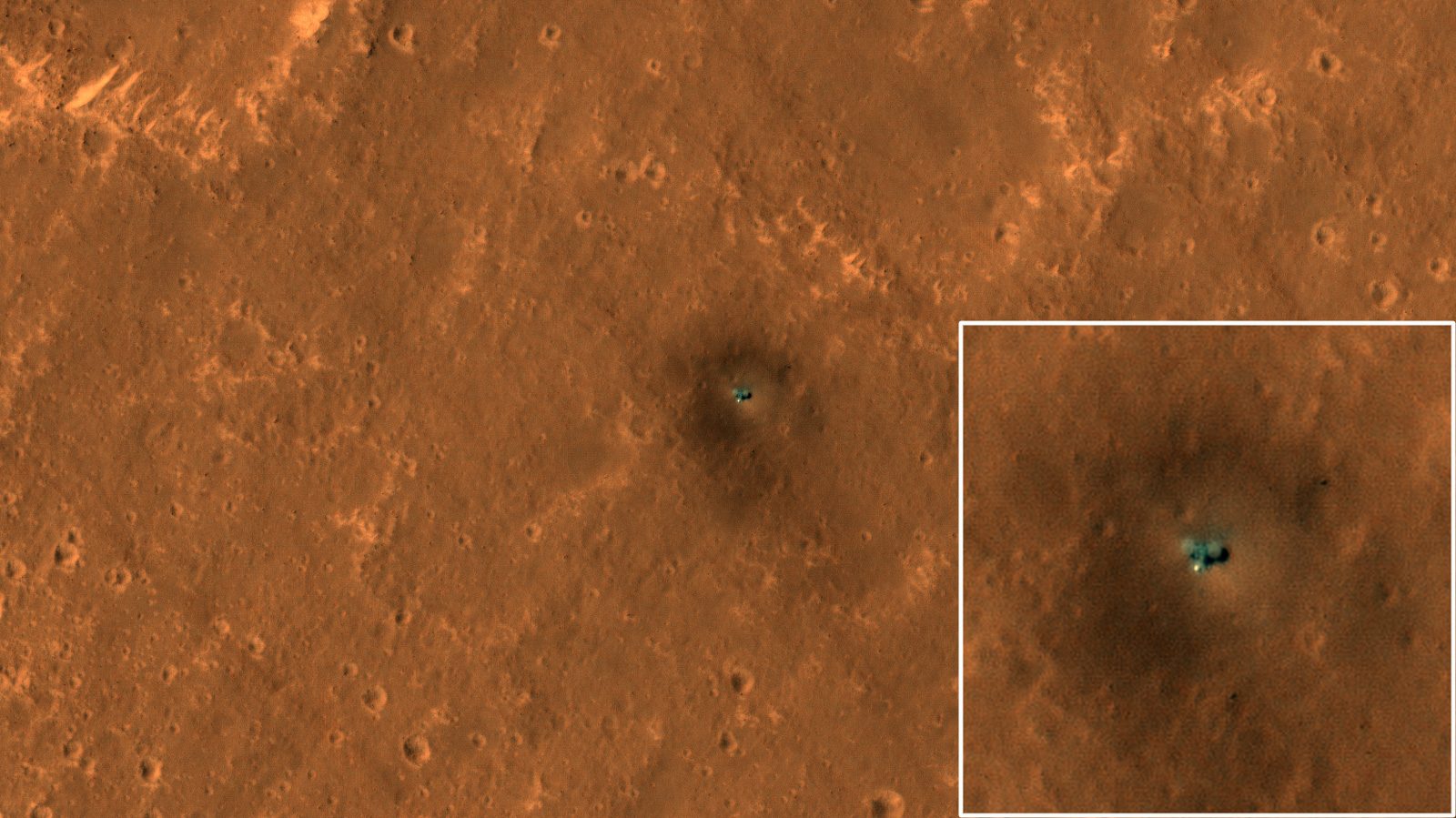
First up, HiRISE took the image above showing the most detailed aerial view yet of the InSight lander. The greenish speck in the middle of the image is the landing site in the Elysium Planitia region, and you can see the two circular panels that the lander uses to collect solar power. Just below the lander, you can see the dome of the heat shield covering the seismometer which is listening out for marsquakes.

Related Videos

This animation shows the position of NASA’s Curiosity rover as it journeyed through “the clay-bearing unit” on Mars between May 31 and July 20, 2019. The HiRISE camera on NASA’s Mars Reconnaissance Orbiter took both images. Credit: NASA/JPL-Caltech/University of Arizona.
About 373 miles (600 kilometers) away from InSight, the Curiosity rover is exploring, as you can see in the images above.

This is not the first time that HiRISE has spotted Curiosity on the surface of Mars. In an image released in July this year, HiRise saw Curiosity in a location called Woodland Bay, part of a region called the clay-bearing unit in Mount Sharp. That image was detailed enough that you could even make out Curiosity’s mast which holds instruments like the ChemCam for analyzing rock samples.

Curiosity is still in the clay-bearing now, though it will soon be moving on to a new area called the sulfate-bearing unit. Between May and July, the rover traveled 1,106 feet (337 meters) from Woodland Bay to a new location called Sandside Harbour. In the animation above, Sandside Harbour is in the middle near the bottom of the image, next to the dark patch of sand. Above the rover, you can even make out the tracks left by Curiosity as it moved through the area.

Curiosity is now collecting data about the composition of rocks in the area, in order to learn more about the history of water on Mars and whether the planet was ever capable of supporting life.

Editors' Recommendations

Astronaut’s stunning image of Key West looks like a painting
Key West from the ISS.

Japanese astronaut Koichi Wakata has been showing off his photography skills, sharing some impressive shots taken from the International Space Station (ISS) as it orbited Earth on Sunday.

The most impressive among his latest set is this stunner (below) of Key West at the western tip of the Florida Keys archipelago.

Read more
This must be the most beautiful image ever of a rocket launch
A SpaceX Falcon 9 rocket launching from Florida.

The growing frequency of SpaceX launches from the Kennedy Space Center in Florida gives photographers plenty of opportunities to train their long lenses at the ascending rockets in the hope of capturing something special.

SpaceX’s latest launch took place during sunrise on Wednesday morning, and a short while later it shared several stunning images of its Falcon 9 rocket climbing toward space.

Read more
Watch SpaceX footage of Falcon Heavy from launch to landing
SpaceX's Falcon Heavy heading to space.

SpaceX recently shared an incredible 90-second video showing a rocket’s-eye view of a Falcon 9 booster from launch to landing. The sped-up footage went viral and has so far racked up 60 million views on Twitter alone.

Now the spaceflight company has released a similar video showing Sunday’s mission that involved its more powerful, triple-booster Falcon Heavy rocket.

Read more