
Digital Trends may earn a commission when you buy through links on our site. Why trust us?

Here’s where NASA will land astronauts on the moon

Promotional image for Tech For Change. Person standing on solar panel looking at sunset.
This story is part of Tech for Change: an ongoing series in which we shine a spotlight on positive uses of technology, and showcase how they're helping to make the world a better place.
Updated less than 6 days ago

A new image of the moon’s far side shows the region selected for the landing of NASA’s Artemis III mission, which aims to return humans to the lunar surface for the first time in over 50 years. The mission will be to the moon’s south pole, a region of particular scientific interest because it is thought to host water ice in permanently shadowed craters.

NASA has partnered with National Geographic to release a mosaic image of the Shackleton Crater, located at the moon’s south pole. The image of the crater was captured using NASA’s ShadowCam instrument on the Korea Pathfinder Lunar Orbiter spacecraft, with additional images of the surrounding area coming from the Lunar Reconnaissance Orbiter. It’s one of the permanently shadowed craters in the region, meaning it could potentially hold water ice. The crater is also close to several of the potential landing sites.

Shrouded in permanent darkness, the interior of Shackleton crater near the moon’s south pole is revealed in this stunning mosaic. The crater itself was captured by ShadowCam, a NASA instrument designed to peer into the shadowy parts of the lunar surface that has been orbiting the moon for almost a year on the South Korean spacecraft Danuri. The surrounding areas were imaged by the Lunar Reconnaissance Orbiter Camera. Portions of three of the 13 potential landing regions for astronauts during Artemis III can be seen in this image.
Shrouded in permanent darkness, the interior of Shackleton Crater near the moon’s south pole is revealed in this mosaic. The crater itself was captured by ShadowCam, a NASA instrument designed to peer into the shadowy parts of the lunar surface that has been orbiting the moon for almost a year on the South Korean spacecraft Danuri. The surrounding areas were imaged by the Lunar Reconnaissance Orbiter Camera. Portions of three of the 13 potential landing regions for Artemis III astronauts can be seen in this image. Mosaic by NASA, Korea Aerospace Research Institute, Arizona State University

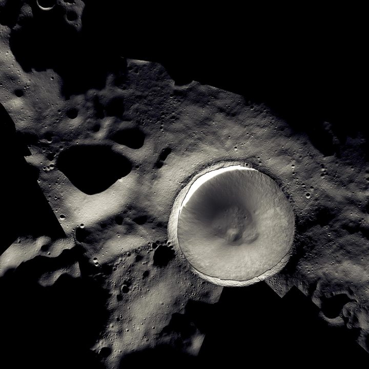
Water ice is rare on the moon as it most often evaporates when the surface it is on faces the sun. However, there are some impact craters around the south pole that the sun’s rays never reach, making them permanently shadowed. It is thought that water ice could persist in these craters, which gives the opportunity for both scientific research and practical resource gathering for crewed missions.

Recommended Videos

“If there is water ice there, then that water ice can be recovered and it can be used for astronaut consumables, it can be used to shield astronauts from harmful space radiation, and the water can be used for rocket propellant,” David Kring, a planetary scientist at the Lunar and Planetary Institute, told National Geographic.

Please enable Javascript to view this content

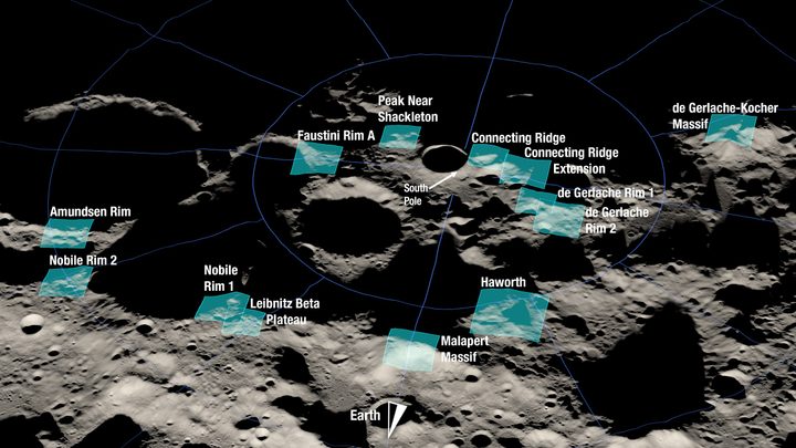
Last year, NASA shared the 13 candidate locations for the Artemis III landing, all of which are close to the lunar south pole and shown below:

Shown here is a rendering of 13 candidate landing regions for Artemis III. Each region is approximately 9.3 by 9.3 miles (15 by 15 kilometers). A landing site is a location within those regions with an approximate 328-foot (100-meter) radius.
Shown here is a rendering of 13 candidate landing regions for Artemis III. Each region is approximately 9.3 by 9.3 miles (15 by 15 kilometers). A landing site is a location within those regions with an approximate 328-foot (100-meter) radius. NASA

Ahead of Artemis III, which is scheduled for 2025, NASA plans to first send a crewed mission around the moon called Artemis II and a lunar rover called VIPER that will search for ice deposits. Both of those missions are set for launch next year.

Georgina Torbet
Georgina has been the space writer at Digital Trends space writer for six years, covering human space exploration, planetary…
Watch incredible video of the Blue Ghost spacecraft landing on the moon
Still from the video of Blue Ghost's lunar landing.

This weekend Firefly Aerospace made history with the first fully successful moon landing by a private company, and now you can watch the moment the Blue Ghost lander touched down on the moon in stunning video footage.

Moon Landing - Firefly Blue Ghost Makes History

Read more
See the first images of the Blue Ghost lander on the surface of the moon
Blue Ghost Mission 1 - Shadow on the Moon's Surface

With the arrival of the Blue Ghost lander on the moon this weekend, get ready for an influx of stunning new images from our planet's natural satellite. The mission, from Firefly Aerospace, touched down in the moon's Mare Crisium region yesterday, Sunday March 2, and the company has already shared the first images captured by the lander from its new home.

As well as a striking image showing the shadow of the lander on the moon's surface, seen above, another image shows the lander on the moon with the Earth visible in the night sky:

Read more
Jubilation as Firefly Aerospace makes history with a nail-biting lunar landing
Rendering of Blue Ghost's descent to the moon's surface.

The moon has a brand new visitor, as Firefly Aerospace has made history by becoming the first private company to ever make a fully successful landing on the moon. The Blue Ghost lander touched down on the moon's surface at 3:34 a.m. ET on Sunday, March 2, coming in for a soft landing and touching down safely and upright with its payload of science experiments and technology tests on board.

With the crater-pocked surface of the moon providing a challenge for landing, the "frankly terrifying" landing process was performed autonomously, with the lander adjusting its trajectory and selecting a safe landing site using a downward-facing camera and software called terrain relative navigation. This allows the lander's onboard computer to accurately gauge its location and speed, and to identify potential hazards to landing such as boulders and craters.

Read more