
A Chinese orbiter has mapped the entire surface of Mars

The Chinese Tianwen-1 orbiter has completed imaging the entire surface of Mars, the China National Space Administration (CNSA) announced this week. The orbiter, which traveled to Mars along with the rover Zhurong, arrived at Mars in February 2021 and has been collecting images of the planet’s surface as part of a global survey.

During its time on the red planet, the Tianwen-1 orbiter made 1,344 passes around the planet and made observations with scientific instruments including cameras, magnetometers, spectrometers, and a radar instrument. The orbiter has been in operation for 706 days, and during that time, the CNSA says it imaged the whole surface with its medium-resolution camera.

Image of Mars surface taken by Tianwen-1 orbiter.
Image of Mars surface taken by Tianwen-1 orbiter. CNSA/PEC

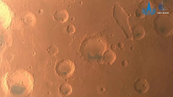
Images collected by the orbiter were shared by space journalist Andrew Jones on Twitter and show a selection of views of the red planet’s surface taken from orbit — including impact craters and other terrain features.

Recommended Videos

Tianwen-1 has completed a global imaging of Mars with its medium resolution camera after orbiting the Red Planet 1,344 times. Tianwen-1 launched in July 2020 and entered Mars orbit in Feb. 2021. Images: CNSA/PEChttps://t.co/LBNqejfu9W pic.twitter.com/UvW9WGjp0Y

— Andrew Jones (@AJ_FI) June 29, 2022

Please enable Javascript to view this content

The Tianwen-1 mission consists of three parts: the orbiter that took these images, the rover Zhurong, and a lander that carried the rover to the surface. The rover has been busy as well, traveling nearly 2,000 meters across the planet in the Utopia Planitia region. However, it is getting colder in this area, so the rover was switched into dormant mode in May and will be reactivated in December once the temperatures warm up.

Both the rover and the orbiter have now completed their primary missions, but as both are still working, they will continue to be used for future exploration. CNSA says it has collected 1,040GB of data from them so far, including orbiter data that has been shared with other space agencies like NASA and the European Space Agency (ESA).

Some commentators have argued this sharing of data is suggestive that the famously secretive CNSA is becoming more open about its work, as demonstrated in a white paper released in 2021, which laid out some of the past and future plans of the agency. The CNSA also announced that its Zhurong rover recently performed an in-orbit relay communication test with an ESA orbiter, the Mars Express spacecraft.

Georgina Torbet
Georgina has been the space writer at Digital Trends space writer for six years, covering human space exploration, planetary…
Elon Musk shares new target date for Starship voyage to Mars
elon musk stylized image

SpaceX is aiming to launch “about five” uncrewed Starship voyages to Mars in two years’ time, according to a post on X (formerly Twitter) by CEO Elon Musk on Sunday.

Musk said that if the uncrewed missions land safely on the red planet, then the first crewed mission could take place as early as 2028, but he added that “if we encounter challenges, then the crewed missions will be postponed another two years” due to the alignment of Earth and Mars that makes such journeys possible. He continued: “We want to enable anyone who wants to be a space traveler to go to Mars! That means you or your family or friends -- anyone who dreams of great adventure. Eventually, there will be thousands of Starships going to Mars and it will a glorious sight to see! Can you imagine? Wow.”

Read more
Check out this incredible cloud atlas of Mars
Arsia Mons Elongated Cloud (AMEC): This elongated cloud has formed as a result of wind encountering the Arsia Mons mountains. It forms almost every day during a specific season, from early morning until noon.

Photographing a beautiful sky is a great passion for many here on Earth, but it can be just as striking on another planet too. Researchers recently presented a stunning new "cloud atlas" of Mars: a database containing 20 years' worth of images of clouds and storms observed on the red planet.

The cloud atlas is available online, inviting you to browse the many images of martian weather captured by the Mars Express spacecraft. This European Space Agency mission has been in orbit around Mars since 2005, and has taken hundreds of images of the planet using its High Resolution Stereo Camera (HRSC) instrument.

Read more
Mars has ‘oceans’ worth’ of water – but it’s deep underground
More than 3 billion years ago, Mars was warm, wet, and had an atmosphere that could have supported life. This artist's rendering shows what the planet may have looked like with global oceans based on today's topography.

One of the key issues for getting humans to Mars is finding a way to get them water. Scientists know that millions of years ago, Mars was covered in oceans, but the planet lost its water over time and now has virtually no liquid water on its surface. Now, though, researchers have identified what they believe could be oceans' worth of water on Mars. There's just one snag: it's deep underground.

The research used data from NASA's now-retired InSight lander, which used a seismometer and other instruments to investigate the planet's interior. They found evidence of what appears to be a large underground reservoir of water, enough to cover the entire planet in about a mile of ocean. But it's inaccessible, being located between 7 to 13 miles beneath the planet's surface. The water is located in between cracks in a portion of the interior called the mid-crust, which sits beneath the dry upper crust that is drillable from the surface.

Read more