
Mars Odyssey spacecraft pulls a sideways maneuver to capture the planet’s horizon

A new image from a NASA orbiter shows an unusual view of Mars that captures the planet’s horizon complete with clouds. It is similar to the kinds of views of Earth that astronauts get from the International Space Station, showing what Mars would look like if seen from a similar vantage point.

The image was taken by NASA’s Mars Odyssey spacecraft, which has been orbiting the planet since 2001. In its over 20 years of operations, the orbiter made key discoveries, including some of the first detections of subsurface ice on the planet. It has also created a global map of the planet’s surface using its Thermal Emission Imaging System (THEMIS) instrument.

This unusual view of the horizon of Mars was captured by NASA’s Odyssey orbiter using its THEMIS camera, in an operation that took engineers three months to plan. It’s taken from about 250 miles above the Martian surface – about the same altitude at which the International Space Station orbits Earth.
This unusual view of the horizon of Mars was captured by NASA’s Odyssey orbiter using its THEMIS camera via an operation that took engineers three months to plan. It’s taken from about 250 miles above the Martian surface – about the same altitude at which the International Space Station orbits Earth. NASA/JPL-Caltech/ASU

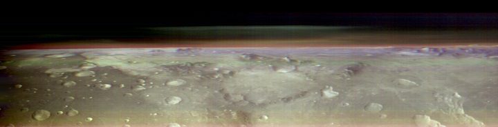
“If there were astronauts in orbit over Mars, this is the perspective they would have,” said Jonathon Hill of Arizona State University, operations lead for Odyssey’s THEMIS camera, in a statement. “No Mars spacecraft has ever had this kind of view before.”

The THEMIS instrument is the same one that was used to capture this image from around 250 miles above the planet’s surface. The spacecraft took a series of 10 images that show the planet’s horizon from beneath the cloud layer, which was a difficult feat that took months of planning to achieve. A big challenge for capturing this image was dealing with the THEMIS camera, which is attached to the spacecraft and points straight down toward the surface.

“I think of it as viewing a cross-section, a slice through the atmosphere,” said Jeffrey Plaut, Odyssey’s project scientist at NASA’s Jet Propulsion Laboratory. “There’s a lot of detail you can’t see from above, which is how THEMIS normally makes these measurements.”

To capture a better view of the atmosphere that included layers of clouds and dust, the entire spacecraft needed to roll over onto its side while still keeping its solar panels pointed toward the sun. In order to get into the right position, the spacecraft’s communication antenna had to be pointed away from Earth, so the team was out of communication with the craft throughout the maneuver.

The spacecraft spent an entire orbit rolled onto its side, and during this time it also captured images of one of Mars’ two small moon, Phobos.

Editors' Recommendations

Georgina Torbet
Georgina is the Digital Trends space writer, covering human space exploration, planetary science, and cosmology. She…
Map of Mars shows the location of ice beneath the planet’s surface
In this artist’s concept, NASA astronauts drill into the Martian subsurface. The agency has created new maps that show where ice is most likely to be easily accessible to future astronauts.

One of the challenges of sending human explorers to Mars is that, due to the logistics of the journey, they will have to be on the planet's surface for considerably longer than the missions of a few days which have been sent to the moon in the past. That means future explorers will need access to resources like food, water, and oxygen -- and rather than having to carry months' worth of supplies through space, it's far more efficient to find ways to produce those resources on Mars itself.

That's the idea behind searching for water ice deposits on Mars. There's plenty of ice on the surface around the planet's poles, but most mission concepts are more focused on the planet's equatorial region. The good news is that there is ice present in these areas too, but the bad news is that it's primarily located below the surface and is thus hard to locate.

Read more
Mars flyover video shows a stunning network of valleys
mars flyover video shows a stunning network of valleys esa

Fly across Mars’s ‘labyrinth of night’ with Mars Express

The European Space Agency (ESA) has released a gorgeous video visualizing part of Mars’ Noctis Labyrinthus, a vast system of deep valleys that stretches for around 740 miles (1,190 kilometers), or for context, roughly equal to the length of Italy.

Read more
Perseverance rover catches footage of a dust devil on Mars
mars 2020 perseverance rover

Many of the weather events we experience here on Earth can be found on other planets too, and that includes whirlwinds. Several missions have observed small whirlwinds called dust devils on Mars, and the Perseverance rover recently captured footage of one such dust devil in action as it rolled across the martian surface.

The footage was captured by one of Perseverance's black-and-white navigation cameras, called Navcams, and shows a dust devil moving at a speed of around 12 mph across a regions known as the Thorofare Ridge. You can clearly see the dust devil as a white column moving across the top of the ridge in an animation posted by NASA's Jet Propulsion Laboratory, which manages the rover.

Read more