
But there’s lots of work to do before we’ll be ready for a person to set foot on the red planet.
Of all the resources that visitors to Mars will require, one of the most significant is water – not only for drinking, but also for making rocket propellant and other substances like oxygen. And if we’re hoping to set up agriculture there, we’ll need a whole lot of water to keep crops growing.
But the surface of Mars looks like a dry, inhospitable desert. Today, Mars has no lakes, no rivers, and no rainfall.
So where will we get our water from? We spoke to three experts to find out.
This article is part of Life On Mars – a 10-part series that explores the cutting-edge science and technology that will allow humans to occupy Mars
Finding water on Mars
Even though we’re many years away from establishing a fully operational base on Mars, space agencies like NASA are already thinking about the water issue. Bringing water from Earth is impractical – it’s far too heavy to carry all the water required for a mission in a rocket. So the plan is to collect water from the Mars environment, and to do that we’d need to know where water is located.
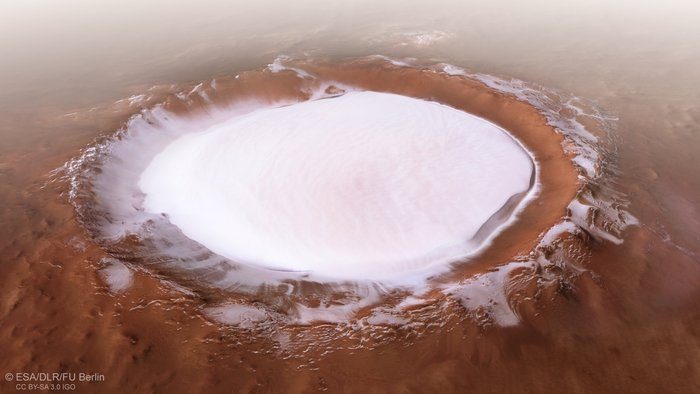
The good news is that there is plenty of water in the form of ice on the surface of Mars, including ice covering the poles and in huge craters. The bad news is that a mission to these freezing cold regions presents its own problems, like the amount of energy it would take to keep both humans and machines warm in temperatures as low as -240°F. That’s why the focus of most Mars missions are the mid-latitude regions, where temperatures are milder.
There isn’t ice on the surface in these regions, though there is ice below ground. But unless you want to send out an astronaut with a shovel to sample every patch of dirt on the planet, you need a way to map that subsurface ice quickly and efficiently.
X marks the spot
That’s what Gareth Morgan and Than Putzig of the Planetary Science Institute are working on as part of the Subsurface Water Ice Mapping (SWIM) project. They and their colleagues have combined 20 years of data from five different orbital Mars instruments to map out where ice is most likely located beneath the surface. On their own, each dataset, such as radar readings or indications of hydrogen, can only tell you so much about whether ice is in a particular location, but in combination, they can indicate what the prime locations for finding ice would be.
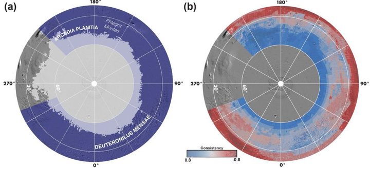
The goal of their work is to help NASA select future landing sites for crewed missions so astronauts could access subsurface ice, while allowing as much freedom as possible to select a scientifically interesting exploration area.
“Technology and engineering is going to define how to put humans on Mars,” Morgan said, “and they’re going to have their own constraints of where that can happen. They also want the science community to find the most scientifically viable, interesting, fascinating places to land. So our job is to bridge both those worlds by giving both teams a broad understanding of where the resources are.”
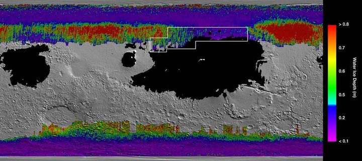
This map can show where ice is likely to be found, but only if that ice is less than five meters below ground. It’s also difficult to be precise about exactly how deep the ice is located in any given area because the sensing methods used can only provide rough estimates of ice content there.
And there’s a big practical difference in how difficult it is to access ice that’s a few inches below the surface versus ice that’s beneath meters of dense rock.
A new tool for detecting ice
To work out how deep ice is on Mars, we’ll need new efforts like the Mars Ice Mapper mission: A spacecraft that NASA and other international space agencies are working on together that will orbit Mars and use two types of radar methodologies to detect how deep ice is located under the surface.

“The central idea is to have a higher-frequency, higher-resolution radar,” Putzig explained. The Ice Mapper mission is still in its concept stage, and he and Morgan aren’t directly involved in it. But they have heard about the concepts for the mission from other scientists, and they shared some details about how it will work.
The first radar method the mapper will use is called synthetic aperture radar imaging. This involves a radar pointed at an angle to the surface, which “gives you a sense of the broad distribution of shallow ice,” Putzig said. “You can map that out over a large region relatively quickly with that method.”
The second method is radar sounding, where the radar is pointed straight down to bounce off the top of the layer of ice. This tells you how deep the ice layer is. When you combine the two, “you get a map view and a cross-sectional view,” he said.
And then you know where to dig.
Accessing the water once we find it
Locating ice is just the first step in collecting water. To get from blocks of solid ice beneath the ground to clean, safe water for drinking and other purposes, we’ll need to find a way to extract and process the ice.
If you know how deep the ice is located and you think there is a sizable amount of ice to access, you can drill down to get to it. The problem, as Sydney Do, the Mars Water Mapping Project lead at NASA’s Jet Propulsion Laboratory, explained, is that you need to know what kind of rock you will be drilling through so you can bring the right tool for the job.
Currently, our understanding of the composition of the Mars surface and subsurface is limited, which has caused problems on Mars missions like InSight, where the lander’s heat probe couldn’t get beneath the surface because the soil had slightly different levels of friction than was expected. So we’ll need more information about the composition of rocks in a particular area before we can design a drill to tunnel into it.
Once you’ve drilled a hole down to the ice, you can use a system called a Rodriguez well, currently in use on Earth in places like Antarctica, to access water. Essentially, you submerge a heated rod into the drilled hole, which melts the ice and creates a well of liquid water that you can then pump to the surface. This requires supplying energy in the form of heat, but it’s an efficient way to access potentially large amounts of water.
Baked rocks
There is also another option for collecting water: We could extract it from hydrated minerals, which are plentiful in many areas of Mars. There are rocks like gypsum there that contain water, and if you crush, then bake those rocks, you can condense the water and collect it.
But spotting these minerals isn’t easy. To identify these hydrated minerals from orbit, researchers use a technique called reflectance spectroscopy. The instruments on spacecraft around Mars can detect sunlight as it is reflected from the surface, creating what are called spectra. Some wavelengths of the reflected light are absorbed by certain chemicals, allowing scientists to infer what the rocks below are made of. But this signal is only the average for the area being observed, and there can be multiple chemicals that absorb the same wavelengths. So deciphering the different signals can be a challenge.
“The way I like to explain it is: You have a cake that you’ve received,” said Do. “You have to try and figure out what ingredients it was made out of and how much of each ingredient contributed to making that cake. That’s essentially what we’re doing with these reflective signals – we’re trying to decompose them into their constituent parts to figure out what’s in there.”
Making water safe
Either way, once you have collected water by melting ice or by baking rocks, you need to process it. The water could be full of harmful impurities like heavy metals or salts like perchlorates, so it needs to be cleaned and desalinated before it can be used. In theory, we know how to do this from doing similar processing to water on Earth, but a challenge on Mars is that we don’t currently know what contaminants to expect.
Like many aspects of water management on Mars, the issue is not in the concept but in the execution. The technology for managing water on Earth is well understood, but there’s still much to do before we could build a system that would work on another planet.
“We know the fundamental principles for doing this,” Do said. “But we don’t fully understand the environmental conditions in which we would have to operate this machinery.” Everything from Mars’s thin atmosphere to its low gravity to its plentiful dust could change the way that machines operate. Not to mention that not only would a water system have to be small and light enough to be put on a rocket, it would also have to be extremely reliable — there are no repair shops on Mars.
This is where the next frontier of technological innovation will emerge. We have the knowledge right now of how to build a system for extracting and processing water, Do said, “but turning those principals into technology that works in a reliable fashion in the environment that we expect it to – that’s still open.”
This article is part of Life On Mars – a 10-part series that explores the cutting-edge science and technology that will allow humans to occupy Mars


