
A Google Maps mistake filled a tiny Norwegian town with confused tourists

google maps error norway pulpit rock
Nanisimova/123RF
Google Maps is great, but it doesn’t always get it right, as a small village in Norway recently learned.

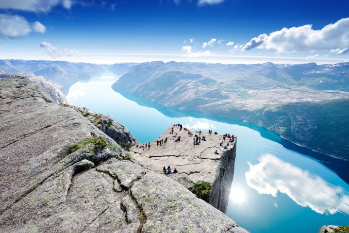
Fossmark, a tiny fjord community about 170 miles southwest of the capital city of Oslo, has reportedly been overrun with tourists thinking they’ve arrived at the striking and very beautiful Preikestolen cliff, also known as Pulpit Rock. Trouble is, the scenic spot is 18 miles away on the other side of the water.

Related Videos

The culprit appears to be Google Maps, which has been sending travelers to the settlement, their cars and minibuses apparently clogging up its narrow roads.

One resident told local media they’ve sent “hundreds of tourists away in no uncertainty that they’re on the wrong side of the fjord.” Another said some tourists get “quite upset” when told they’re a good 30-minute drive from their intended destination.

Several residents even have fun handing the lost visitors a pair of binoculars so they can see everyone having a lovely time on the scenic cliff … on the other side of the fjord.

Google encourages users of its Maps app to let it know about any issues so that it can fix them for greater accuracy and to prevent unnecessarily long drives to the wrong destination when using its directions.

With Google Maps covering the entire planet, it’s no surprise that errors like this hit the headlines from time to time. Many years ago the app was sending hordes of drivers to some poor guy’s driveway instead of a state park in New Jersey. And just last year the app was blamed in a case where a demolition firm knocked down the wrong houseOops!

Such hiccups also bring to mind the embarrassing start Apple made with its own Maps app nearly five years ago. Within hours of its launch, users quickly realized it really should have stayed in the workshop for some fine tuning. The mobile software, which replaced Google Maps as iPhone’s default mapping app, mistakenly put an entire city in the sea, labeled a farm as an airport, and even did away with Shakespeare’s home city of Stratford-upon-Avon. Thankfully the app’s troubled days are now far behind it.

Editors' Recommendations

Apple Maps vs. Google Maps: Which one is best for you?

Navigation tools like Google Maps and Apple Maps have changed the way we find places, explore local businesses, and share directions with friends. Both have a similar purpose, but you will find that there are some differences in their navigation tools and interfaces.

If you rely on an Android device, Google Maps is the only option of the two. However, if you own an iPhone, learning more about the differences between Google Maps and Apple Maps will help you choose the best navigation app for your needs.
Maps vs. Maps historical contest
Launched in 2005, Google Maps has been the premier mobile mapping service since the dawn of the smartphone. Apple Maps for the iPhone and iPad, on the other hand, didn't arrive until 2012 and for years it struggled with technical issues. These included wrong directions, lack of support for public transportation, and many glitches and bugs that made the service nearly unusable. All the while, Google Maps continued to improve and reign supreme.

Read more
Google Maps’ new community feed aims to keep you in the loop
4 ways 2020 has changed how i use my tech google maps in hand

Google Maps is getting more social.

Don’t worry, it hasn’t jumped on the bandwagon by becoming the latest app to launch a version of Snapchat Stories (though we can’t say it never will), but instead, it's added what it’s calling a “community feed” to help surface useful tidbits for your local area.

Read more
Google Maps’ latest features aim to ease holiday season stress
google maps new features aim to ease holiday season stress covid layer

Google is adding new pandemic-related data to Maps aimed at getting you safely through the holiday season and beyond.

First up, the Maps team is about to roll out enhancements to the app's so-called “COVID layer” for iOS and Android. Launched in September, the feature offers lots of insightful pandemic data, such as recent case numbers for the part of the map that you have on the screen. You can enable the layer by tapping on the app’s “COVID-19” button at the top right-hand corner of your display.

Read more