
Say cheese: InSight lander posts a selfie from the surface of Mars

NASA’s InSight mission to Mars touched down on the red planet’s surface at the start of the month, and now, like any good Millennial, it has commemorated its arrival at its new home by posting a selfie.

The InSight selfie is a composite of 11 different images which were taken by one of its instruments, the Instrument Deployment Camera. The lander has a robotic arm which it uses to move equipment around on the surface of the planet, and on the elbow of this arm is the camera. The many individual images captured by the camera are then sent back to Earth where they are stitched together to show the lander in its full glory.

This is NASA InSight’s first full selfie on Mars. It displays the lander’s solar panels and deck. On top of the deck are its science instruments, weather sensor booms and UHF antenna. NASA/JPL-Caltech

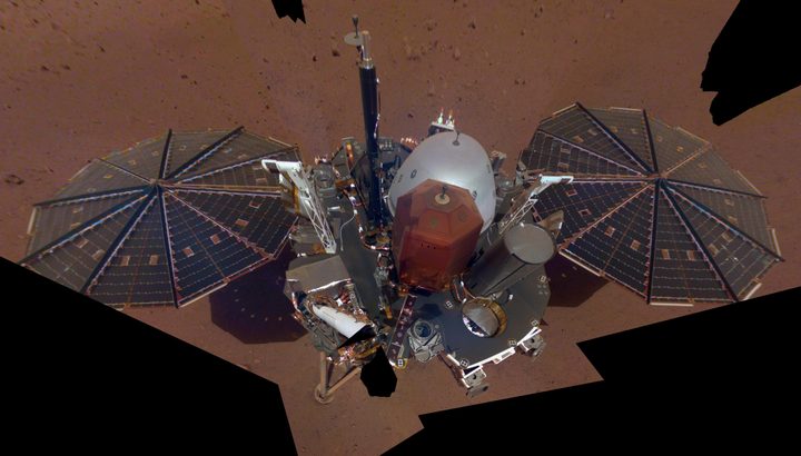
This image is not just for fun though, as it also gives NASA scientists important information about the area around InSight, which is known as its “workspace.” The workspace is the area of approximately 14×7 feet (4×2 meters) which is in front of the lander, and information about this area was gathered by stitching together a total of 52 different photos. The scientists can then use this visual information to help them decide where to place the spacecraft’s instruments such as the seismometer which will look for “Marsquakes” by gathering data about the vibrations coming from deep within the planet.

Moving InSight’s instruments onto the surface of Mars is a delicate process as the instruments work best when placed on level ground, and the lander is currently in a slight crater. Also, the team need to avoid rocks or other potential hazards which are bigger than half an inch or so, in order to avoid damaging the equipment. Fortunately, InSight’s Principal Investigator Bruce Banerdt of NASA’s Jet Propulsion Laboratory doesn’t think that will be a problem in the area around the lander: “The near-absence of rocks, hills and holes means it’ll be extremely safe for our instruments,” he said. “This might seem like a pretty plain piece of ground if it weren’t on Mars, but we’re glad to see that.”

Editors' Recommendations

Georgina Torbet
Georgina is the Digital Trends space writer, covering human space exploration, planetary science, and cosmology. She…
See seasonal changes on Mars in two stunning images from MAVEN
mars maven ultraviolet seasons orbit16863 apo ladfit localff png

The planets in our solar system experience seasons because of the way that they are tilted in their orbits, so one hemisphere is facing the sun more often at some times of year than others. However, there's another factor which also affects weather and conditions on some planets, which is their position in their orbit around the sun. Earth has a relatively circular orbit, so the differences caused by it being slightly closer or further from the sun at different points are minimal. But Mars's orbit is much more eccentric or oval-shaped than Earth's, meaning conditions differ based on when the planet is closer to the sun.

That effect is illustrated in two images of Mars recently released by NASA, which show the planet at its closest and furthest point from the sun. Taken by a Mars orbiter called MAVEN, or Mars Atmosphere and Volatile EvolutioN, the images were taken six months apart in July 2022 and January 2023 respectively, showing how the environment of the planet changes with both season and the planet's orbit.

Read more
See a postcard from Mars taken by the Curiosity rover
NASA’s Curiosity Mars rover used its black-and-white navigation cameras to capture panoramas of “Marker Band Valley” at two times of day on April 8. Color was added to a combination of both panoramas for an artistic interpretation of the scene.

Today, you can enjoy a stunning new view of Mars, thanks to a postcard from the Gale Crater taken by the Curiosity rover. The image combines two different views of the same area and is colorized to show off the undulating martian landscape in a region called the Marker Band Valley.

The image, shared by NASA's Jet Propulsion Laboratory (JPL), shows the back of the rover and views of the tire tracks it has left across the martian surface as it has driven. The view on the left side of the image was taken in the morning of April 8, at 9:20 a.m. local Mars time, while the image on the right side was taken on the same day but in the evening, at 3:40 p.m. local Mars time. The two images have been blended together to show how the landscape looks different throughout the day.

Read more
NASA’s June skywatching tips include Mars in the Beehive
how to photograph perseid meteor shower night sky with

What's Up: June 2023 Skywatching Tips from NASA

NASA is back again with its monthly roundup of what to look out for in the sky over the coming weeks.

Read more