
NASA has just offered an update on its ambitious SPHEREx mission, which plans to map the entire sky from low-Earth orbit when it launches in the next couple of years.
Short for Spectro-Photometer for the History of the Universe, Epoch of Reionization and Ices Explorer, SPHEREx is starting to come together in a clean room at NASA’s Jet Propulsion Laboratory in Southern California, with the spacecraft’s distinctive cone shape already clear for everyone to see.
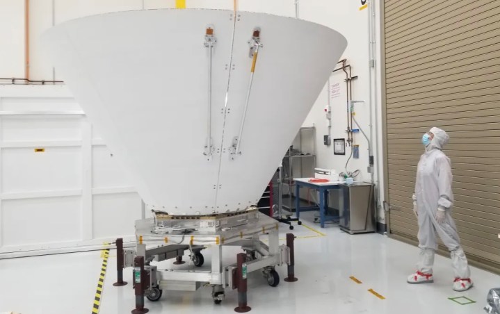
There are a further two smaller cones nestled within the outer one. These surround SPHEREx’s telescope to protect it from the light and heat of the sun and Earth when it’s in orbit.
“SPHEREx has to be quite agile because the spacecraft has to move relatively quickly as it scans the sky,” JPL’s Sara Susca, deputy payload manager and payload systems engineer for the mission, said in Thursday’s update. “It doesn’t look that way, but the shields are actually quite light and made with layers of material like a sandwich. The outside has aluminum sheets, and inside is an aluminum honeycomb structure that looks like cardboard — light but sturdy.”
Built by Ball Aerospace in Boulder, Colorado, the spacecraft’s all-important telescope will collect infrared light from distant sources using three mirrors and six detectors.
Over two years, the SPHEREx telescope will map the entire sky four times to create a huge database featuring galaxies, stars, nebulae, and other celestial objects.
The aim of the mission is to help scientists gain a better understanding of where water and other key ingredients necessary for life originated. The mission will do this by measuring the abundance of water ice in interstellar clouds of gas and dust, places where new stars form and where planets are eventually created.
The SPHEREx team will also be able to study the cosmic history of galaxies, learning more about when they began to form and how they’ve changed over time.
Last but not least, scientists will be able to use SPHEREx’s map of millions of galaxies to try to find out more about how the rapid expansion of the universe occurred a fraction of a second after the Big Bang.
NASA confirmed the SPHEREx mission in 2019 and SpaceX will launch the spacecraft from Vandenberg Space Force Base in California no later than April 2025.
Editors' Recommendations
- NASA and Boeing start fueling Starliner spacecraft for first crewed flight
- NASA’s damaged Ingenuity helicopter spotted in Mars rover photo
- Perseverance joins the 1,000-sols club on Mars, gets congratulated by Curiosity
- NASA’s Mars helicopter still working fine after month-long break
- NASA’s Mars helicopter just did something it’s never done before


