
Observing wild activity on the sun could help predict space weather

When the Solar Orbiter spacecraft made its closest flyby of the sun to date in March this year, it scooped up vast amounts of data from which we can learn about our star. The European Space Agency, which is running the mission in collaboration with NASA, has shared a raft of material from the preliminary analysis of this data, including the highest resolution image of the sun’s south pole captured to date:

Solar Orbiter’s highest resolution image ever of the Sun’s south pole

This footage was taken by Solar Orbiter’s Extreme Ultraviolet Imager (EUI) instrument on 30 March 2022, when the spacecraft had just passed its closest point to the sun so far. The sun’s poles have rarely been studied because they are hard to view, but they may be crucial to understanding the sun’s magnetic field.

Related Videos

Other aspects of the sun’s activities are being revealed too, like the relationship between loops of hot gas at 1 million degrees Celsius, captured by EUI, and the magnetic fields which shape them. “Nobody has ever seen the details of the corona in that much detail before, so every time we get an image down it’s the first time we see something at that much scale. And that’s really fascinating,” said the principal investigator of the EUI instrument, David Berghmans, in a video posted by ESA.

Solar activity captured by Solar Orbiter.
Solar activity captured by Solar Orbiter’s EUI instrument. ESA & NASA/Solar Orbiter/EUI & PHI Teams

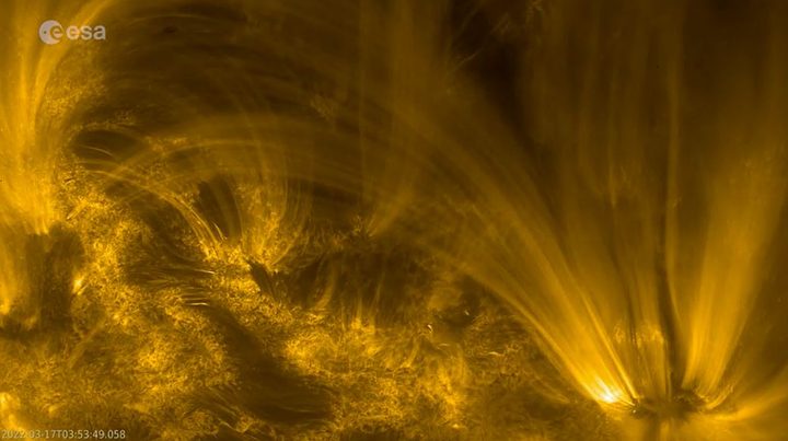
This image showing the loops of gas was captured at the same time as data from the Polarimetric and Helioseismic Imager (PHI) instrument which records magnetic activity. By comparing the two, researchers can see how the magnetic activity on the surface of the sun, called the photosphere, is driving gas into loops that reach far out from the surface and into space.

This is the process that underlies dramatic solar events like flares and coronal mass ejections, when hot plasma is sent streaming out from the sun. This in turn has effects throughout the solar system, in a phenomenon called space weather. The researchers hope that Solar Orbiter data can be used to not only understand the sun but also to predict this space weather.

“Solar Orbiter is basically a research mission, but ultimately we want to be able to predict space weather,” explained project scientist Daniel Müller in the video. “These are energetic events which could have an impact on high-tech installations on Earth, like GPS satellites or power grids. We want to make sure that in the future we can predict geomagnetic storms based on solar activity. And for that, we really need to take the sun’s temperature and measure the solar wind and connect the two.”

Editors' Recommendations

Look out, space billboards could be coming to a sky near you
Satellites reflecting sunlight to form the shape of the Olympic rings.

It’s an idea that will send a shiver down the spines not only of astronomers who need clear skies to do their work, but also of regular folks who sometimes like to gaze dreamily toward the heavens to immerse themselves in the beauty of the universe.

We’re talking about space ads. Space ads created by constellations of small satellites.

Read more
See the horror of the sun up close from world’s most powerful solar telescope
The first images of the chromosphere – the area of the Sun’s atmosphere above the surface – taken with the Daniel K. Inouye Solar Telescope on June 3rd, 2022. The image shows a region 82,500 kilometers across at a resolution of 18 km. This image is taken at 486.13 nanometers using the hydrogen-beta line from the Balmer series.

The astronomy community has a new tool for studying the sun, with the inauguration this week of the world's largest solar telescope. The Daniel K. Inouye Solar Telescope, located in Maui, Hawai'i, has a 13-foot (4-meter) primary mirror enabling it to see the sun in phenomenal detail.

To celebrate the telescope's inauguration on August 31, 2022, this week the National Science Foundation (NSF) released a new image of the sun's chromosphere. This is the part of the sun's atmosphere that is right above its surface, and the image shows a region 50,000 miles across where temperatures can be as high as 13,000 degrees Fahrenheit.

Read more
Water map of Mars could help choose locations for future missions
Data from ESA's Mars Express and NASA's Mars Reconnaissance Orbiter have been used to create the first detailed global map of hydrated mineral deposits on Mars. Click here for an annotated version with mineral types and abundances.

Whether you're thinking about the future of Mars and how to send humans there, or trying to understand its past and see how the planet became the way it is today, one particular feature is crucially important: water. Scientists know that there was once abundant water on Mars, but over time this evaporated away and left the planet a dry husk, with little to no liquid water on its surface today. But that water has left indications in the geology of the planet, and now the European Space Agency (ESA) has shared a water map of Mars that traces the planet's history and points to potential resources for future missions.

The map uses data collected by two different Mars orbiters, ESA's Mars Express and NASA's Mars Reconnaissance Orbiter. Spectrometers on each of the orbiters have been collecting information on the location of what is called aqueous minerals, meaning rocks that have interacted with water in the past and which have formed minerals such as clays.

Read more