
RIP, Cassini: 25 spellbinding Saturn images from NASA’s self-sacrificing probe

The Cassini-Huygens spacecraft has spent nearly two decades in space collecting invaluable data and unprecedented close-ups of the Saturnian system. The craft has logged nearly 5 billion miles on its cosmic odometer, and the library of Cassini images contains more than 400,000 images and counting.

Cassini sports 18 unique scientific instruments and is 12,593 pounds making it one of the largest and heaviest space probes ever constructed.

From the drawing board onward, the Cassini mission was set to be one of the most ambitious unmanned missions ever launched into the cosmos. Tricked out with 18 unique scientific instruments, the spacecraft hit the launchpad at a not-so-svelte 12,593 pounds, making Cassini one of the heaviest and largest interplanetary probes ever constructed. In fact, only the two interplanetary spacecraft (Phobos 1 and Phobos 2) launched by the Soviet Union were more massive.

Once hurled into the solar system, Cassini spent the next seven years braving the unforgiving vacuum of space before even reaching Saturn. A system glitch, meteorite, or haphazard collision with any number of orbiting hunks of space junk could’ve killed this $3 billion dollar mission before it even started. Fortunately, this was not Cassini’s fate, and on July 1, 2004, the probe finally arrived at its destination. The spacecraft would spend the next 13 years investigating the enigmatic gas giant and relaying data back to us earthlings nearly 900 million miles away.

After successfully executing more than 2.5 million commands including 162 targeted flybys of Saturn’s moons, Cassini boasts a rather lengthy list of accomplishments. Outside of discovering previously unknown moons (no big deal) and observing massive hurricanes at both Saturnian poles, the craft also detected the elements necessary to potentially host living organisms on the ice-spewing satellite, Enceladus.

NASA illustration of Cassini on final dive towards Saturn. NASA/JPL

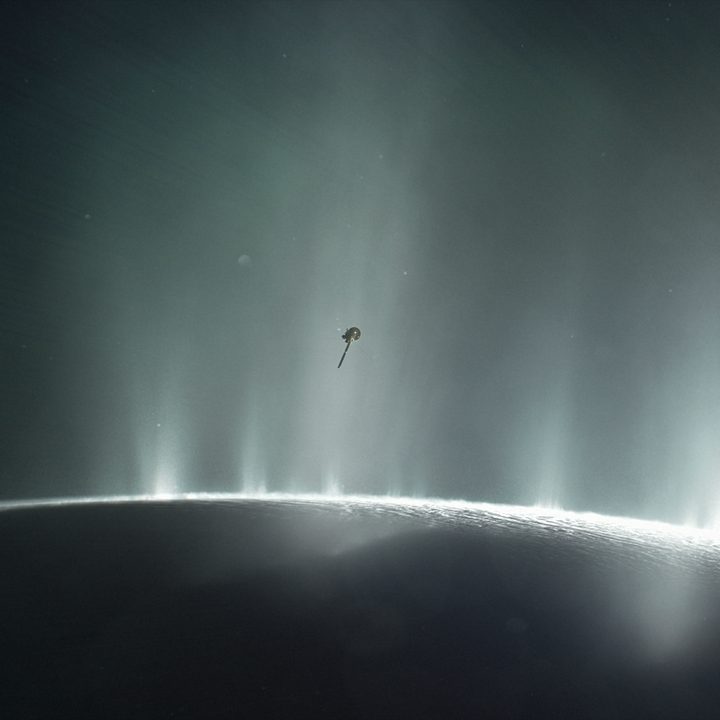
Unfortunately, in the cosmic scheme of things, nothing lasts forever, and even the stalwart Cassini is not exempt from the inevitable. Protecting these aforementioned potentially life-sustaining “ocean worlds” is the central purpose of the so-called Grand Finale that will culminate with a final “suicide dive” into Saturn’s tumultuous atmosphere. This subsequent series of dives toward the planet will prevent Cassini from possibly contaminating one of these potentially life-sustaining moons with sturdy microbes that may have survived the journey from Earth.

The craft began the first of these plunges in August and earlier this week Cassini received its “goodbye kiss” from Titan, a final flyby and consequential gravitational nudge toward Saturn. The steadfast craft is expected to crash into the planet’s atmosphere on September 15, 2017, transmitting data to the bitter end.

Of the more than nearly half a million images the probe has snapped during its 20 years adrift in the solar system, these are 25 of our favorite. Godspeed, Cassini.

If you’re craving more stunning glimpses of our celestial neighbors and beyond, we’ve also curated a gallery of the best photos of outer space.

Dallon Adams
Former Digital Trends Contributor
Dallon Adams is a graduate of the University of Louisville and currently lives in Portland, OR. In his free time, Dallon…
Hubble scientists create tool for erasing satellite trails from images
This image captures the streak of an Earth-orbiting artificial satellite crossing Hubble's field of view during an observation of "The Mice" interacting galaxies (NGC 4676). A typical satellite trail is very thin and will affect less than 0.5% of a single Hubble exposure. Though in this case the satellite overlaps a portion of the target galaxy, the observation quality is not affected. That's because multiple exposures are taken of the same target. And the satellite trail is not in other frames. Developers at the Space Telescope Science Institute in Baltimore, Maryland, have software that identifies the bad pixels from the satellite photobombing, the extent to which they affect the image, and then flags them. When flagged, scientists can recover the full field of view. Even as the number of satellites increases over the decade, these tools for cleaning the images will still be applicable.

With ever-increasing numbers of satellites in the sky, astronomers have repeatedly expressed worry over how these satellites could impact scientific research. Earlier this year, a study of Hubble Space Telescope observations showed how some images were being ruined by streaks of light coming from satellites -- and while only a small percentage of Hubble images were affected, the authors raised concerns that with the projected number of satellites set to explode in the next decade, the problem could become serious.

Now, astronomers at the Space Telescope Science Institute (STScI), which runs Hubble, have come up with a tool to deal with satellite streaks in Hubble images. "We developed a new tool to identify satellite trails that is an improvement over the previous satellite software because it is much more sensitive. So we think it will be better for identifying and removing satellite trails in Hubble images," said Dave Stark of STScI in a statement.

Read more
See the first image of Earth from a new weather-monitoring satellite
First image of the full Earth disc from the Meteosat Third Generation Imager. The first image from Meteosat Third Generation – Imager 1 (MTG-I1) reveals a level of detail about the weather over Europe and Africa not previously possible from 36 000 km above Earth. The higher-resolution images provided by the instruments on board give weather forecasters more information about the clouds cloaking much of Europe and visible in the equatorial region of Africa and the Atlantic Ocean. Sand and sediment in the waters off Italy are also visible, as well as dust or smog being carried from south Asia. This degree of detail is not possible from the instruments on the Meteosat Second Generation satellites. The image was captured at 11:50 UTC on 18 March 2023 by the Flexible Combined Imager on MTG-I1.

A recently launched weather satellite has sent back its first image of Earth, showing our planet in gorgeous detail. The European Meteosat Third Generation Imager-1 was launched in December of last year with the aim of monitoring weather conditions across Europe and Africa, and it took this image from its location 22,000 miles above the Earth's surface.

The image was taken using the high-resolution Flexible Combined Imager instrument in March 2023, showing the areas of cloud and clear skies that can be seen over the Atlantic Ocean, as well as the European and African land masses.

Read more
Enjoy these amazing space images by NASA’s oldest active astronaut
Don Pettit aboard the space station.

At 67, Don Pettit is NASA’s oldest active astronaut. During three trips to the International Space Station (ISS) -- in 2002, 2008, and 2011 -- Pettit earned a reputation as a highly skilled photographer who created extraordinary images of the ISS, Earth, and beyond.

Pettit, who describes himself as “an engineer by schooling, a scientist by profession, and an explorer by heart,” continues to share his amazing pictures on Twitter and Instagram, wowing his many followers on the social media platforms.

Read more