
This giant map of minerals on Mars is a piece of modern art

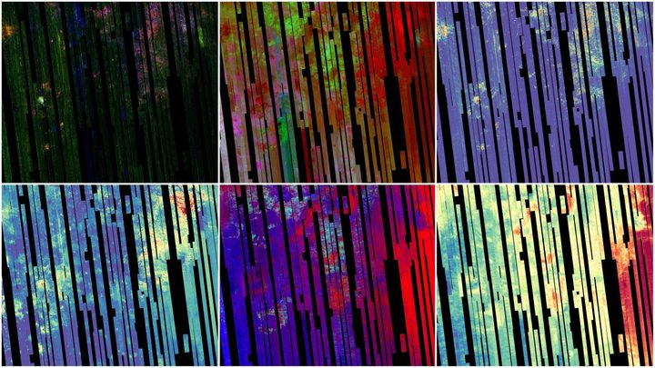
The rainbow-hued images might look like some kind of digital art, but in fact, they are maps of Mars, taken using the Compact Reconnaissance Imaging Spectrometer for Mars, or CRISM, an instrument on board NASA’s Mars Reconnaissance Orbiter (MRO).

This spacecraft has been in orbit around Mars since 2006, taking images of the planet using its cameras such as HiRISE and also gathering spectrometer and radar data. CRISM is a spectrometer, meaning it splits light into different wavelengths to see what an object is made of. Different colors in the different maps below represent particular minerals on the Martian surface, allowing researchers to look at the planet’s geology from orbit.

Seen are six views of the Nili Fossae region of Mars captured by the Compact Reconnaissance Imaging Spectrometer for Mars, or CRISM, one of the instruments aboard NASA's Mars Reconnaissance Orbiter.
Seen are six views of the Nili Fossae region of Mars captured by the Compact Reconnaissance Imaging Spectrometer for Mars, or CRISM, one of the instruments aboard NASA’s Mars Reconnaissance Orbiter. NASA/JPL-Caltech/JHU-APL

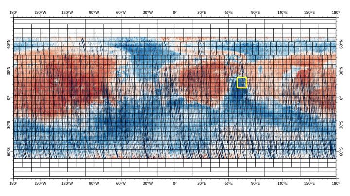
NASA recently released the first part of a highly detailed map of almost the entire surface of Mars, in the form of a 5.6 gigapixel image in 72 colors. This was created from over 50,000 segments, each a strip around 330 miles in length and six miles wide, which were stitched together to create the final map. This map shows the overall reflectiveness of each patch of the Martian surface, with redder portions of the map being places where there is lots of bright red dust, and darker portions being rockier and less dusty.

This near-global map was captured by NASA’s Mars Reconnaissance Orbiter using its Compact Reconnaissance Imaging Spectrometer for Mars, or CRISM. The yellow square indicates the Nili Fossae region of Mars, which is highlighted in six views in the previous image.
This near-global map was captured by NASA’s Mars Reconnaissance Orbiter using its Compact Reconnaissance Imaging Spectrometer for Mars, or CRISM. The yellow square indicates the Nili Fossae region of Mars, which is highlighted in six views in the previous image. NASA/JPL-Caltech/JHU-APL

There will be batches of CRISM data corresponding to each individual tile of the map, like those shown in the image at the top of the page, released over the next six months until the survey is complete. The total coverage of CRISM data will include 86% of Mars’s surface, providing an invaluable map of where key minerals are located. From this, researchers can both understand more about the history of water on the planet and identify new targets for scientific research or even help choose landing sites for rover missions.

“It’s effectively a whole new data set that will fuel a second wave of discoveries about Mars’ surface composition,” said CRISM’s principal investigator Scott Murchie in a statement. “In fact, one of the objectives of the next MRO extended mission is for its HiRISE camera to go back and image in color the hundreds of new high-science priority spots we’re finding in the map — spots that haven’t been imaged at high resolution because their importance wasn’t known.”

There will also be another map released later this year showing the location of iron-bearing minerals, which are helpful to understand the history of water on the planet and could even help in the search for evidence of ancient life there.

“The CRISM investigation has been one of the crown jewels of NASA’s MRO mission,” said Richard Zurek, the mission’s project scientist at NASA’s Jet Propulsion Laboratory. “Analyses based on these final maps will provide new insights into the history of Mars for many years to come.”

Editors' Recommendations

Georgina Torbet
Georgina is the Digital Trends space writer, covering human space exploration, planetary science, and cosmology. She…
NASA’s June skywatching tips include Mars in the Beehive
how to photograph perseid meteor shower night sky with

What's Up: June 2023 Skywatching Tips from NASA

NASA is back again with its monthly roundup of what to look out for in the sky over the coming weeks.

Read more
Perseverance rover finds evidence of an ancient river on Mars
NASA’s Perseverance Mars rover captured this mosaic of a hill nicknamed “Pinestand.” Scientists think the tall sedimentary layers stacked on top of one another here could have been formed by a deep, fast-moving river.

The Perseverance rover has been exploring Mars's Jezero Crater as part of its mission to search for evidence of ancient life on Mars. The history of water is key in the search for life, and it is currently thought that Mars lost its water around 4 million years ago. Now, the rover has identified evidence of what was once one of the deepest and fast-flowing rivers yet discovered on the planet.

The rover captured a series of hundreds of images using its Mastcam-Z instrument, which were put together into this mosaic showing a hill structure called Pinestand. In the image, you can see the many layers left behind by the flowing river, which were formed by deposits of sediment.

Read more
Ingenuity and Perseverance snap photos of each other on Mars
The Ingenuity helicopter on the surface of Mars, in an image taken by the Perseverance rover. Ingenuity recently made its 50th flight.

Everyone's favorite Mars double act, the Ingenuity helicopter and the Perseverance rover, have been traveling together recently after spending several months apart. As they explore the site of an ancient river delta in the Jezero crater, the pair have snapped images of each other that were recently shared by NASA.

The Perseverance's cameras caught this great shot of Ingenuity, which, as noted in the rover's Twitter post, is now considerably dustier than it was when it first deployed from under the rover's belly two years ago. In its two years on the red planet, Ingenuity has made more than 50 flights, which is incredible when you consider that it was designed to perform just five flights. During that time, Ingenuity had to take a break from long flights to deal with the cold martian winter, but since the beginning of the year, the helicopter has been back, making some of its longest flights yet.

Read more