
See a gorgeous icy crater on Mars captured by the Trace Gas Orbiter

The European Space Agency (ESA) has released a stunning new image of an icy crater on Mars, taken by the Trace Gas Orbiter. The Trace Gas Orbiter, a collaboration between ESA and Russian space agency Roscosmos, primarily examines the gases in the martian atmosphere but also takes images of the surface and acts as a communication link between landers and rovers on the surface and Earth.

This striking image shows a crater 2.5 miles wide near Mars’s northern pole, in the Vastitas Borealis region:

Related Videos
The contrasting colors of bright white water-ice against the rusty red Martian soil.
Like a sprinkle of powdered sugar on a rich red velvet cake, this scene from the ESA/Roscosmos ExoMars Trace Gas Orbiter captures the contrasting colors of bright white water-ice against the rusty red Martian soil. ESA/Roscosmos/CaSSIS

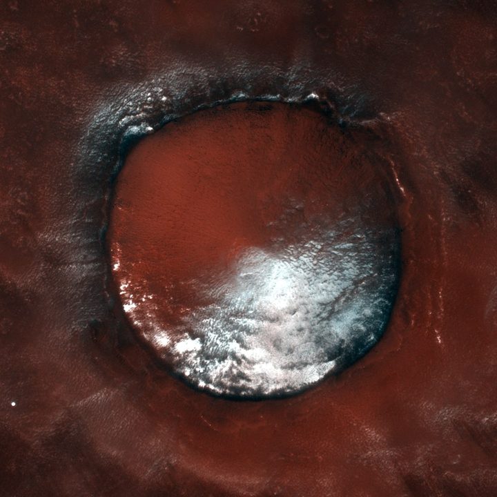
The color differences show the red Martian soil contrasted with water ice inside the crater.

“The crater is partially filled with water ice, which is also particularly predominant on its north-facing slopes that receive fewer hours of sunlight on average throughout the year,” ESA writes. “The dark material clearly visible on the crater rim – giving it a somewhat scorched appearance – likely consists of volcanic materials such as basalt.

“Most of the surrounding terrain is ice free, but has been shaped by ongoing aeolian processes. The streaks at the bottom right of the image are formed by winds that have removed the brighter iron oxide dust from the surface, exposing a slightly darker underlying substrate.”

Finding water on Mars is a big challenge for potential crewed missions there, as water is too heavy to carry all the way to Mars on a rocket. One option for future explorers is to find craters on the planet that contain water ice, like this one or the famous Korolev crater, which could be melted down and used for drinking and for fuel. However, most places where there is ice on the surface of Mars are around the poles, and most missions want to visit the equatorial regions.

Another option is to look beneath the surface for ice, which is the plan of upcoming missions like the Mars Ice Mapper. A final option would be to take hydrated minerals from the soil and bake them to release the water they contain.

Editors' Recommendations

Mars Express orbiter snaps an image of Mars’s ‘Grand Canyon’
This image from ESA’s Mars Express shows Ius and Tithonium Chasmata, which form part of Mars’ Valles Marineris canyon structure. This image comprises data gathered by Mars Express’ High Resolution Stereo Camera (HRSC) on 21 April 2022.

The sights of Mars are many and marvelous -- and the European Space Agency (ESA)'s Mars Express orbiter recently captured one of the planet's wonders, the Valles Marineris canyon system.

This enormous canyon system is nearly 2,500 miles long and over 120 miles wide, and is more than 4 miles deep in places. That makes it 20 times wider and five times deeper than Arizona's Grand Canyon, according to ESA. This gigantic size makes it the largest known canyon system in the solar system, and studying it can help researchers learn about the geological processes which formed and continue to shape Mars.

Read more
A Chinese orbiter has mapped the entire surface of Mars
tianwen 1 orbiter mapping qcvcmep8cv2mncghhqvpup 970 80 jpg

The Chinese Tianwen-1 orbiter has completed imaging the entire surface of Mars, the China National Space Administration (CNSA) announced this week. The orbiter, which traveled to Mars along with the rover Zhurong, arrived at Mars in February 2021 and has been collecting images of the planet's surface as part of a global survey.

During its time on the red planet, the Tianwen-1 orbiter made 1,344 passes around the planet and made observations with scientific instruments including cameras, magnetometers, spectrometers, and a radar instrument. The orbiter has been in operation for 706 days, and during that time, the CNSA says it imaged the whole surface with its medium-resolution camera.

Read more
This giant map of minerals on Mars is a piece of modern art
Seen are six views of the Nili Fossae region of Mars captured by the Compact Reconnaissance Imaging Spectrometer for Mars, or CRISM, one of the instruments aboard NASA's Mars Reconnaissance Orbiter.

The rainbow-hued images might look like some kind of digital art, but in fact, they are maps of Mars, taken using the Compact Reconnaissance Imaging Spectrometer for Mars, or CRISM, an instrument on board NASA's Mars Reconnaissance Orbiter (MRO).
This spacecraft has been in orbit around Mars since 2006, taking images of the planet using its cameras such as HiRISE and also gathering spectrometer and radar data. CRISM is a spectrometer, meaning it splits light into different wavelengths to see what an object is made of. Different colors in the different maps below represent particular minerals on the Martian surface, allowing researchers to look at the planet's geology from orbit.

Seen are six views of the Nili Fossae region of Mars captured by the Compact Reconnaissance Imaging Spectrometer for Mars, or CRISM, one of the instruments aboard NASA's Mars Reconnaissance Orbiter. NASA/JPL-Caltech/JHU-APL

Read more